Exploring the Ramalingeswara Temple

The amazing thing about living in Bangalore is that in any direction I choose, each road going out of the city leads us to some special location, all within a radius of 100 kilometers.

Today we drive to a remote village called Avani to explore a 10th-century temple. Avani is a small village in Karnataka in the Kolar district, situated at a distance of 80 km from Bangalore.

It was February and the skies appeared so blue and devoid of haze, it was just vanilla to the eyes. So on an early Saturday morning, we jumped into our SUV and left towards Kolar.

Bangalore to Avani

The NH75 leading towards Kolar is fascinating. It is a pleasure to drive on these well-maintained roads, never mind the measly toll I had to pay twice.

The high-rise buildings along Whitefield were soon replaced by empty stretches of land with nothing but rocks and boulders. Along the way, my wife, Ranita spotted a lovely tree standing by itself in the endless barren land.

After crossing Kolar, we left the highway and turned right at the RPG Service Station. We drove for another 6 km along a pebbled road before we reached a settlement. A local villager helped us on our way towards the Ramalingeswara temple, which lies at the base of Avani Betta (hill).

The temple is protected by the Archaeological Survey of India (ASI) as a monument of national importance. Even though the temple structures were created sometime between the 9th-10th century, as per the ASI an inscription here dates way back to 399 CE.

Mythology of Avani

The name Avani is of Dravidian origin. It means “Earth”. The village finds a mention in history dating back to the days of the epic tale of Ramayana. Though it is debatable as Ramayana was written sometime around 500 BC. It is said that sage Valmiki’s ashram was located on a nearby hillock called Avani betta and it was here that the twin sons of Rama; Luv and Kush were given birth by Sita.

This part of the story when Sita lives in this ashram carries on from the time when Rama ascended the throne of Ayodhya. A rumor began doing the rounds about Sita, his wife, questioning her chastity due to her being kidnapped and kept as a prisoner by the Asura king Ravana.

According to the mythology, even the Gods attested to the chastity of Sita during the agni-pariksha, where she walked through fire to prove her purity. King Rama, in order to set an example of an ideal king, banished, would-be mother, Sita into exile. Banished and helpless, she was provided shelter by sage Valmiki in his ashram at Avani. I will not go into details about how she reached Avani from Ayodhya, which are more than 2000 km apart, but let us just enjoy the story.

Sita was very much distressed about being exiled, especially because she was already pregnant at that time. She started living in the ashram of sage Valmiki, heartbroken, always thinking about Rama. In due course, she gave birth to twin boys, who were named Luv and Kush.

Valmiki raised them in his ashram, imparting them all his Vedic knowledge. Even though he didn’t inform them of their parentage, he raised them like Kshatriyas (warriors). Years passed and the boys grew into adolescents.

Back in the kingdom of Ayodhya, it was advised to Rama that he perform the Ashvamedha yagya. The Ashvamedha yagya was used by ancient Indian kings to prove their imperial sovereignty. As a part of this yagya, a ceremonial horse was left to wander at will for a period of one year. Wherever the horse traversed, any rival could dispute the king’s authority by challenging the warriors accompanying it. However, everyone bowed to the majestic white horse from Ayodhya, accepting the greatness of Rama.

Wandering aimlessly, the horse reached the gates of Valmiki’s ashram. Luv and Kush who were still adolescents were charmed by the majestic white horse and they captured it. They had no idea about the purpose of the horse and brought it into their ashram. When asked to return the horse by the accompanying army, they boldly challenged the warriors to a fight.

As the news spread to Ayodhya, Rama sent Lakshman, his brother, to recover the horse. Against all odds, Lakshman was defeated by the young brothers. He was followed by Bharat and Shatrughan who also tasted defeat at the hands of Luv and Kush.

Surprised and shocked, Rama himself had to come to fight Luv and Kush. A battle broke between Luv-Kush and Rama. But before anything unfortunate happened, rishi Valmiki approached the scene and stopped the battle. He divulged to the kids, their parentage and commanded them to ask for forgiveness from their father.

On knowing the reality of the twin princes, Rama, and his brothers installed four shivalingas each in their respective names to absolve their sin, which they committed by waging war against the two adolescents.

These established shivalingas were called Ramalingeshwara, Lakshmanalingeshwara, Bharathalingeshwara & Shatrugnalingeshwara each for the four brothers. Successive kings later constructed a temple complex around these sacred lingas.

Ramalingeswara group of temples

Parking our car in front, we entered 10th-century temple through a huge gateway. The ancient temples known as the Ramalingeshwara group of temples were constructed during the period of the Nolamba reign. The Nolambas were a relatively minor South Indian dynasty compared to the Cholas, Chalukyas, and the Vijaynagara empire. They were feudatories of the Rashtrakutas and ruled over the south-eastern region of Karnataka which covers present-day Kolar and Tumkur. They were Shaivites and the temples they built were dedicated to Shiva. They ruled from 735 to 1052 CE and are also credited with the creation of the Bhoganandishwara Temple in Nandi.

The temples in the complex are built with granite blocks in the Dravidian style and they were initially commissioned by the Nolamba dynasty. Once the Cholas overpowered the Nolamba, they added some renovations of their own.

As I mentioned earlier, the temple complex comprises four main shrines dedicated to the four brothers – Rama, Lakshman, Bharat, and Shatrughan. It is said these lingas were installed by Rama and his brothers themselves in order to seek forgiveness from Shiva for fighting with Sita’s children – Luv and Kush.

Ramalingeshwara Temple

It was still early in the day and we were the only ones at the temple complex. The first structure we went inside was the Ramalingeshwara temple. It is sandwiched between the Lakshmaneshwara temple and the Shatrugnalingeshwara temple.

The temple consists of a sanctum (garbhagriha), a vestibule (antarala) and a hall (navaranga) with decorative pillars. The temple porch and pillars are decorated with various deities. I could make out a depiction of Trivikrama on the southern wall. This pillar, just before the entrance below has Ganesha carved into it.

On another pillar, I found this carving of a warrior. It could be a depiction of the war fought here.

The walls of the temple are also designed with various images of gods surrounded by floral motifs. The inner sanctum of the temple was poorly lit but I was able to snap this shot of the main deity, goddess Parvati.

You might be surprised to know that of all the existing religions only the Sanatan dharma followed by Hindus in India worship female goddesses.

Lakshmaneshwara Temple

To the west of the Ramalingeshwara temple lies the shrine dedicated to his younger brother Lakshman. The outer walls have pilasters surmounted by towers (shikhara).

This temple also has a garbhagriha, an antarala, and a navaranga. It is the most ornate of all the temples and houses the largest shivalinga. A Nandi statue sits near the doorway facing the shivalinga.

The big hall called navaranga is supported by four beautifully carved pillars with a rounded shivalinga at the far end. The pillars in the center depict dancers and musicians. Shielded from the wind and sun by the surrounding walls, they still have the carvings in a very healthy state.

Another interesting aspect of this temple is the carvings on the ceiling which display a sculpture of Uma-Mahesvara (Shiva with his consort Parvati) surrounded by an ensemble of ashtadikpalas (guardians in eight directions).

Let me give you a closer look at this fabulous work of art.

After exploring the interiors we walk towards the back of the temple where you can find a daring carving of the Kali goddess.

Apart from goddess Kali there are other gods and goddesses along the wall of the Lakshmaneshwara Temple. At the base pedestal of the Lakshmaneshwara Temple, you can see some really old inscriptions that have help understanding the history of the place. Many of them are barely visible because of constant erosion.

Beyond the Lakshmaneshwara Temple, the path turns north. In a corner, you can find another small temple called the Vigneshwara Temple with a small and beautiful idol of Ganesha

Shatrugneshwara Temple

On the east of the Ramalingeshwara Temple lies another similar temple, which is called the Shatrugneshwara Temple. It has a similar design as the Lakshmaneshwara Temple with decorated pillars and a ceiling. The Nandi statue here is missing. Maybe it was broken or more probably stolen.

This temple too has various deities carved into the ceiling with Uma-Mahesvara in the center.

This hall is also supported by decorated hexagonal pillars depicting dancers.

After exploring these three main temples, we went around to the northern part of the temple complex. Along the way, we captured some shots of deities along the walls of the Shatrugneshwara Temple.

This is an image of Natesha along the walls of the Shatrugneshwara Temple

The pedestal of this temple too contains some inscriptions which are in a much better condition than from the Lakshmaneshwara Temple. The external decorative elements of the temples for all shrines include friezes of elephants and lions. The design pattern is consistent with the temples in Hampi that were created during the heights of the Vijayanagar empire.

Right after, there is a mini temple dedicated to Vali and Sugreeva, the kings of Kishkindha.

Navagraha Temple

Just behind the Vali Temple is a mandap housing the Navagraha (the nine planets). What is Navagraha? It is the 9 other planets in the Solar System. Do not confuse this number with the total number of planets in our Solar system. In Vedic Astrology, Moon, Rahu, and Ketu are also considered planets. Anyways, it is still awesome to conclude that while the world was still debating whether the Earth was flat or not, Indian sages already knew about the existence of 7 planets that made up our Solar system. Take that Cambridge scholars!

..while the world was still debating whether the Earth was flat or not, Hindu sages had not only learned about the existence of 7 planets in the Solar system, but also how they exert themselves on human existence

The Hindus believe that Navagrahas play a key role in their destiny. and are responsible for all the good or bad times one faces in life. According to Vedic Astrology, significance is attached to the positions of the nine planets in the twelve constellations of the zodiac. People believe that the transition of Saturn, Jupiter, Rahu, and Ketu from one zodiac sign to another sign will bring good or bad or mixed fortunes.

Coming around a full circle, we found ourselves in front of a big Nandi sculpture.

From here we walked towards the back of the temple grounds.

At the back of the temple, we found a pranala jutting out of the temple. The pranala is a discharge outlet attached to the wall of the sanctum. It is used to discharge the abhisheka-teertham water, milk, ghee, etc. poured over the temple idols during worship.

From the back of the temple complex, one can see Avani hill in the background which we will be hiking later.

After a thorough exploration of the temples, we moved on towards the Avani hill, where at the summit, another piece of the puzzle of Ramayana waits for us.

Hidden away in obscurity, Ramalingeshwara Temple is another gem in the heritage of Karnataka. It is interesting that these places with connections to Ramayana keep popping over all over the place. Structurally maybe these might not be as amazing as the monolithic temples of Mahabalipuram or the enchanting monuments in Hampi, but these stories keep my interest going. Thanks for reading. Please leave me a comment if you liked the post. After exploring the temple complex, we set off for the hike to Sita Parvati temple at the top of Avani betta.

What is the best time to visit Ramalingeshwara Temple?

An annual festival is held for seven days from the 14th day of Magha-Bahula in honor Ramalingeshwara.

Heritage walk to Vittala Temple

Today I went on a heritage walk to the majestic Vittala Temple. Built around the 15th century CE, and expanded several times by succeeding kings of the Vijayanagar empire, it is the epicenter of Hampi’s attractions. This time, I was in Hampi along with a trekking group from Bangalore.

It was another day of missed opportunities. I was awake at 5 am, ready for new experiences in Hampi. We were supposed to observe the sunrise from Anjaneya hill as per schedule but our trek leader himself got up at 6 am and by that time hiking up Anjaneya hill was a lost cause.

I wandered around the open spaces near our lodging. it was pleasant with no vehicular pollution or noises in the serene surroundings.

By the time everyone was ready, it was already 9 am. We drove down to Anegundi, the nearest town where we took our breakfast in one of the local dhabas. The idlis, served by a lovely lady were delicious. Just across the street, a wooden Rath was stationed. These chariot like structures are used during the rath festival in these parts.

From there the bus dropped us off near Talwar Gatta, where a ferry helped us across to the other side. Honestly, I was a bit scared, since they didn’t have any life jackets and one is always hearing about ferries toppling over in India.

History of Hampi

Hampi, believe it or not, the whole town is a UNESCO World Heritage Site. It was traditionally known by many names, the prominent ones being Pampapura or Pampakshetra. These names were derived from Pampa which was the name of the river Tungabhadra in those ancient times.

The recorded history of Hampi goes back a long way. Archaeologists have discovered rock edicts from the time of Emperor Asoka in Bellary, not very far from here, dating 269-232 BCE, suggesting this region could have been a part of the Maurya Empire way back in the 3rd century BCE.

Along-with the prosperity of the Vijaynagar empire, Hampi became a centre of religious and educational activities. But I would be biased to other dynasties if I only sing praises of the Vijaynagara kings. Hampi had already gained quite popularity by the 10th century. Inscriptions at Virupaksha temple, a kilometer along the Tungabhadra, are evidence to Chalukya kings making land grants to the temple.

Later between the 12th and 14th centuries CE, kings of the Hoysala Empire also built temples dedicated to the goddess Durga and lord Shiva. During this time, Hampi had almost become a secondary home of the Hoysala kings.

With time, it went on to become the epicenter of the Vijayanagar Empire in the 14th century. Chronicles left by Persian and European travelers, particularly the Portuguese, state Hampi was a prosperous, wealthy and grand city near the Tungabhadra River, with numerous temples, farms and trading markets.

By 1500 CE, Hampi was considered the world’s second-largest medieval-era city attracting traders from Persia and Portugal. Unfortunately, nothing lasts forever and the splendor of Hampi attracted many invaders. In 1565, the Vijayanagar Empire was attacked and defeated by a coalition of Muslim sultanates. Its capital was conquered, pillaged and destroyed by sultanate armies leaving the heritage city in ruins. It is said these invaders looted the city over a period of six months, snatching the valuables and burning all that remained to the ground.

History of  Vittala Temple, Hampi

After a short walk from the river, I found myself at the parking area for Vittala Temple. From here visitors can either wait for a buggy or simply walk to the temple, which is a bit of a distance away. A queue had already built up, so if you desire a peaceful experience please come early. While others in my trek group waited for the guide, I made my way to the temple.

The Vittala temple was originally built in the 15th century AD, during the reign of King Devaraya II (1422 – 1446 A.D.), one of the rulers of the Vijayanagara Empire. Many successive kings have expanded and enhanced the temple campus during their regimes to the present form.

Records from the 16th centure redfer to this complex as “Vitthala.” The temmple complex extends over a distance of about a kilometer. The temple was called the Vijaya Vittala predominantly. In one of the records, it is also mentioned as Kanada Vitthala. It is assumed that the “Vijaya” in the name Vijaya Vitthala indicates a celebration victory.

The road leading to the temple is in a completely ruined state. This road was once the location of a thriving market place. The market was known as the Vittala Bazaar and was famous for horse trading. The ruins of the market can be seen on both sides of the road.

The buggy dropped me off near the entrance tower. One typically accesses the campus through the eastern gate, next to which the ticket counter is located. Behind the ticket counter lies the remains of a township called Vittalapura that existed around this temple complex. The first foundations of the temple were laid around 1505 CE. The eastern gate or gopuram was constructed between the years 1513 to 1516.

The Vittala temple complex

The temple is built in the form of a sprawling campus with compound wall and gateway towers. There are many halls, pavilions and temples located inside this campus. The iconic temple has amazing stone structures such as the incomparable stone chariot and the fascinating musical pillars.

The Vittala Temple is also known as Shri Vijaya Vitthala Temple. It is dedicated to Lord Vitthala, an incarnation of Lord Vishnu. An idol of Vitthala-Vishnu was enshrined in the temple.

Notable among the structures are the shrine of the Goddess (Devi shrine), Maha Mantapa or main hall (Sabha Mantapa or congregation hall), Ranga Mantapa, Kalyana Mantapa (marriage hall), Utsava Mantapa (festival hall), and the famous Stone Chariot.

The Vijaya Vitthala temple is a stupendous creation of the Vijayanagar artists with few paralells in the architectural history of medieval India. The main attractions of the Vittala Temple are listed below:

Stone Chariot of Vittala Temple

The first structure I noticed was the sculpted Stone Chariot, which is considered to be the most stunning architecture of the Vijayanagara kingdom. Designed in the shape of an ornamental chariot with the idol of Garuda, it is an iconic landmark of Hampi. The structure is classified as a Karakkoil, a temple fashioned after temple chariots which are taken in procession around the temple during festivals.

The Stone Chariot or Ratha stands in the courtyard of complex and welcomes the visitors as they enter the temple grounds. Even though it appears to be one, the Stone Chariot is not a monolithic structure. As per Hindu mythology, Garuda is the carrier of Lord Vishnu and its image is enshrined into the sanctum. The popularity if this iconic sculpture has led to it being part of the Indian currency in the denomination of Rupees fifty.

The stone chariot may be the first structure see as you enter the Vittala complex, but it is also the most recent.

Just like the Shore temple of Mahabalipuram, this shrine was also built with blocks of granite. The joints are cleverly hidden in the carvings and other decorative features that adorn the stone chariot. The chariot was built on a rectangular platform. The base platform is adorned with mythical battle scenes chiseled into the granite on all sides.

The chariot is adorned with a set of four finely sculptured granite wheels. Though the chariot is not resting on it, the four giant wheels are extremely well detailed and good enough to compete with real life ones. A series of concentric floral motifs decorate the sides of the wheels. The platform, where the wheels rest, shows clamps were later added to fix it from moving around the axis. Some older pictures of the stone chariot show it with a shikhara and the kalasha which have now eroded away. The wheels of the stone chariot are said to be once functional and could be rotated by the people. But some years ago the ASI cemented the wheels in order to avoid causing damage to them.

In front of the chariot two elephants are positioned as if they are pulling the chariot. However if you look carefully, you can see the difference in the style of sculpting. These elephants were supposedly added at a later stage after the chariot was completed. Originally two horses were carved in that position. The rear legs of the horses can be still seen just behind these elephant sculptures.

Maha Mandap of Vittala Temple

On leaving the Stone Chariot, I walked down to the main hall in front of the Vittala temple. Unfortunately the entrance to the Maha Mandap was blocked for maintenance. The first time I was here a couple of years back, people used to be allowed inside the main hall.

The Maha Mandapa or main hall of the Vittala Temple is situated in the inner courtyard, bang in the center of the temple complex just behind the Stone Chariot. It is a structure of immense beauty, sitting on a highly ornate base carved with a series of floral motifs. Maha mandap along the axis of the main temple has a pillared hall with three entrances. A series of steps flanked by elephant balustrades gives access to this elevated open hall called the Maha mandap.

The balustrades on the east and west porch of this hall is more dramatic with giant lion Yalis fighting the relatively dwarf elephants.

There are forty pillars lining the facade of the temple. The central part of the Maha Mandap has sixteen intricately decorated pillars having beautiful sculptures of Narasimha and Yali.

These richly carved giant monolithic pillars set of sixteen pillars forms a rectangular court. The sikhara of the Maha Mandap is very much in ruins, more so because it was created out of mud bricks.

The Musical Pillars of the Maha Mantapa:

The Dolotsava Mandap is other main attraction of the Vittala Temple. The most outstanding components of the Vijay Vitthala Temple is the eastern pavilion of the Maha Mandap.It was originally called Dolotsava Mandap or “Hall of Musical Pillars” This large mandap is renowned for its 56 musical pillars carved out of huge single pieces of resonant stone. This cluster of musical pillars are also known as SAREGAMA pillars, named after the notes of the classic Indian music – Sa, Re, Ga, Ma, etc. It is said musical notes are emanated when the pillars are tapped gently.

The original foundations of the Dolotsava Mandap were laid sometime during the reign of two Devarayas (1406 – 1446 CE ) of the Snagama Dynasty. It experienced further expansion during the time of Tuluva Krishnadevaraya (1503 -1528 AD) It was further expanded upon during the reigns of Achyutdevaraya( 1529 – 1546 AD) and Sadasivaraya (1542-1565 AD)

The analysis of these pillars has revealed that the rocks are resonant because of the presence of metallic ore and large amounts of silica.

The base is decorated with carvings of warriors, horses, swans and several other ornamental designs. The lowermost of it is a chain of horses, its trainers and the traders.

Every main pillar is surrounded by 7 minor pillars. These 7 pillars emit 7 different musical notes from the representative musical instruments. The notes emanating from these pillars vary in sound quality depending on whether the instrument is a percussion, string or wind instrument. When one of the columns is struck, the reverberation moves though the other nearby columns. However, if you find yourself at this site on a Sunday afternoon, forget about being able to hear any music over the ‘hum’ of the large crowds that throng this temple.

The emission of musical notes from stone pillars was a mystery that fascinated many people down the centuries. After conquering the region, the Mughals tried to burn down the temple but it turned out futile since the temples were carved out of granite.

After the Mughals, the country fell prey to the British. They too tried to damage the temple every way they could, pillaging away any artifact that could be carried away to their country. Two of these pillars were cut off by the British, who were surprised by the musical notes of the pillars and wanted to examine them in more detail. However, they found out that the pillars had nothing inside them.

I believe that tapping the musical pillars to emit musical notes is now prohibited, as tapping over the years have caused some damage to the musical pillars of the Maha Mandap. But the local guides fake it on the pillars of the other mandaps to please the tourists.

Most of the granite and sandstone towards the base have survived. The influence of Srivaishnava sect is seen at this temple complex which is revealed by observing minor shrines to the south, west and north. Around this main mandapa are four smaller halls: (clockwise from east)

  • Kalyan mandap
  • 100-columned mandap
  • Amman shrine and
  • Bhoga mandap

After capturing the exteriors of the Maha Mandapa, I moved towards the Kalyan mandapa on the left.

Kalyan Mandap

You can find more pictures of the Kalyan Mandap here.

100 Pillar Mandap

The “Hundred Pillared Hall” has altogether 108 pillars in all. It is said to be commissioned in 1554 AD. Below are close-up shots of some of the pillars.

Amman shrine

From the 100 column mandap, I made my way towards the back of the Maha Mandap where a small temple lies un-bothered and unattended by tourists.

Bhoga Mandap

For some reason they built a second marriage hall in the temple grounds. Generally all the temples I have visited only have one Kalyan Mandap. It might well have been for some other reason, the facts of which have been lost to time.

Some other interesting structures around the temple complex

While walking around the complex, I found this lone tree on the grounds. Beside the tree, along the enclosing walls lies a small structure. It is not very decorated and I am not sure about its functionality either, but it looks beautiful. I recall this from the first time I visited Hampi in 2014.

A few steps ahead lies the northern gate. Like the other structures, the base is very much as it was centuries back, but the top parts created using mud are in ruins.

Ruins of Vittala Temple in Hampi

The Vittala Temple is in a partially ruined state. The sanctum of the temple once contained an idol of Lord Vittala. However, now the sanctum is devoid of any idol. The region around the Vittala temple was called Vitthalapura. It hosted a Vaishnava matha (monastery), designed as a pilgrimage centred around the Alvar tradition.

According to historical memoirs left by Portuguese and Persian traders, the city of Hampi was of metropolitan proportions and the Vitthala temple the crown jewel of the kingdom. I have written another article on the still standing ruins of Hampi if you would want to read about the humble beginnings of the forgotten city.

In 1565, at the Battle of Talikota, a coalition of Muslim sultanates entered into a war with the Vijayanagara Empire. They captured and beheaded the king, followed by a massive destruction of the infrastructure of Hampi. The city was pillaged, looted and burnt for six months after the war, then abandoned as ruins. The central western hall of the temple was ruined during the attack of the Delhi Sultanate that eventually led to the downfall of the Vijayanagara Empire in 1565 CE and the end of Hampi.

I have been to Hampi twice and yet it feels like I have to come back many a more times to truly capture its essence in full. I was prepared to stay another day, but the living conditions of our lodgings forced me to catch the bus and head back to Bangalore.

Thanks for reading. Please leave me a comment if you liked the post or follow my story as I visit the mythical birthplace of luv & kush from the epic tale of Ramayana .

Festivals at Vittala Temple in Hampi

The temple has floodlights installed inside the temple complex. The lights illuminate the Vittala Temple Complex at night and offer a majestic view of the beautiful structure against the dark night sky. But if you want to see it, you should come in winter when the days are small. In summers the place closes up well before sunset.

Hampi Festival (November)

This is the largest festival at Hampi. Generally they are scheduled for 3 days during the first week of November. The celebrations typically packed with shows of music, dance puppet shows fireworks and a pomp procession as the grand finale showcasing the cultural richness of the place.

Purandaradasa Aradhana (January/February)

The annual Purandaradasa festival is held at the temple complex. The festival is held every year to commemorate the birthday of the ancient poet Purandaradasa who lived in Hampi. The 2-3 days long program is scheduled during the months of January or February.

Use of tripods is not permitted inside the temple campus.

The monument opens from 8.30 am in the morning to 5.30 pm in the evening. However, try to visit this place soon it opens in the morning. That is the only time you can explore peacefully before the crowd builds up.

Admission fee is Rs 30 for Indian citizens and Rs. 500 for foreign nationals. Preserve this ticket. If you are in Hampi for the whole day, you can use the ticket on the same day to also enter the Zenana Enclosure area.

Built

Early-to-mid-16th century

Built by

King Devaraya II

Admission fee

₹30 for Indian citizens / ₹500 for foreign nationals

Timings

8:30 – 17.30 hrs

The Monkey Kingdom of Kishkindha

Today I went to explore the quiet town of Anegundi. I was here with a trekking group from Bangalore. As per the mythological tale of Ramayana, the city used to be known as Kishkindha in ancient times when Vali and Sugreeva, the monkey kings used to rule these lands. The monkeys though have been driven away by the growing number of tourists and it is just the mystifying boulders that remain to tell us the story of what was once a strange but interesting kingdom.

It was 10 am by the time we rode into the ancient city of Anegundi. The all night drive from Bangalore had been a quiet one. The only excitement was provided by the stunning sunrise whence the golden ball of fire rose over the horizon and removed the darkness from this little corner of the earth. Now simply known as Anegundi, the quaint town lies along the Tungabhadra river.

We checked in to our rooms at the lodge. I will prefer not to name it, it was that horrible. All I can say is the living standards were more qualified to be called a sty. After a breakfast of noodles, which took like forever to be served, we marched on to explore the boulders of Anegundi.

The time before Time itself

While writing this article I had to go through many sources. Rummaging through books on history gave me only half the story. To know the origins of Kishkindha I found myself digging into the the study of ancient Earth itself.

Beyond the temples, the huge boulders are the most interesting things around these parts. These brown rusty granite have been polished through 3 billion years into huge rounded shapes which now lean precariously around hills of piled boulders. Surrounded by these rocks, it is hard to imagine any sizeable population to have been supported here, let alone the core of the Vijayanagar empire.

This region is the bedrock of India known as Peninsular Gneiss, the mass of which is amongst the earliest solidified rock on the planet. The rounded contours and grain show it to have once been molten flowing stuff, but then came the sculpturing work of repeated ice ages. This land mass was pushed by the freezing current of the seas. It kept drifting under the pressure from cooling of the earth’s crust until the sub continent rose from the sea as a plateau.

The stage was now set for the mythical tale of Ramayana, in which the area is referred to as Kishkindha on the Papma river – the mythical kingdom of monkeys. The river that I refer to as Pampa is now named Tungabhadra, after the rivers Tunga & Bhadra which join about 10 miles upstream.

Wandering among the Boulders of Kishkindha

The bus dropped us off at a place called Hippie Island. We walked the rest of the way towards the boulders. This was a busy street with many eateries and lodges. Such was the incursion of foreigners that it was difficult to spot the locals among them. On the other side was a vast area flowing with young saplings of paddy. Though the red mud of Karnataka is not favorable for rice cultivation, the river brings in silt making the area fit for rice cultivation. The flat black silted land between the boulder hills and the busy lodges is thickly planted with patches of coconut palms and paddy fields.

Within the hillocks lie a labyrinth of caves. The medieval kingdom of Vijayanagar around present day Hampi, is tightly intertwined with the Ramayana. I would still want to believe that this region of Kishkindha, the kingdom of the Vanaras, or monkeys, referred to in the epic is just a figment of imagination, but I as explore these parts, I find more and more locations for many significant events in Ram’s journey during his exile. Was it just a well told story or real. Lost in this dilemma, I pushed on towards the hillocks.

The Ramayana connection

The story of Ramayana is deeply embedded in the collective psyche of the Hindus the indigenous population of the Deccan. The wide geographical sweep of this narrative has ensured that every corner of this Indian subcontinent, starting from Ayodhya, is associated with different aspects of its story-line.

Kishkindha is identified to be the regions around the Tungabhadra river (previously referred to as Pampa ) near Hampi and belongs to Koppal district in Karnataka. The rocky landscape strewn with massive boulders is widely believed by many to be the fabled Vanara kingdom of the brothers, Vali and Sugreeva.

According to the Ramayana, after Ravana abducts Sita, Ram’s frantic search for his beloved wife brings him and his brother, Lakshman southwards to Kishkindha. It is here that they meet Hanuman.

At the time, Kishkindha’s rulers, brothers Vali and Sugreeva were embroiled in a bitter feud, with the former determined to kill the latter. This part of the tale has its own story, but I am going to elude that in the interests of keeping this article short(er). In short Ram helps Sugreeva defeat his brother ans ascend to the throne, in return for his help in finding Sita.

Bouldering in Hampi

After a 30 minute walk we were at the summit of a small hillock popular for activities like bouldering. Many of the boulders here are sitting at the edge, dangling in precarious angles.

Many of my trek buddies tried their skills at climbing boulders with the help of a local instructor. I am past my days of subjecting my body to these rigors, so I found myself a quiet place in the shadows between some boulders and laid down re-hydrating myself with a bottle of mineral water.

After an hour of lazing in the shade, while the others flexed their muscles in the sun, we walked back to the inhabited area of hippie island. In the strong sun, it was dehydrating. Grabbing a can of sugary indulgence I made my way back towards the bus.

On the way I passed the ancient Hampi bridge, made entirely of rocks. I was pleasantly surprised to see that it had been repaired in some parts. I clearly remember it being in shambles from when I was here a couple of years back.

Once everyone was on the bus, we drove towards our next destination – Sanapur lake.

Sanapur Lake

Sanapur Lake is a reservoir fed by canal from the Tungabhadra Dam. It is beautiful to watch the wide lake in middle of boulders. Apart from the beautiful scenery one can also enjoy coracle rides at the lake, but at their own risk. The rides don’t provide life-jackets.

Sanapur Lake is one of those ‘secret attractions’ around Hampi. Honestly, I was not aware of it, the last time I toured this region. The natural lake with stunning boulder hills all around makes it a beautiful locale to spend the evening.

Sanapur Lake is still a less frequented place. You’ll not find a large tourist crowd in this locale. I was told that this place is sought after for cliff diving even though you can find dozens of warning about crocodiles in the water. 

Evening was arriving at a swift pace and we set off from the lake to hike up one of the hillocks to experience the famous sunset over Anegundi.

Sunset over Kishkindha

Let me confess, I don’t recall the name of this hill. I am not sure if it even has a name. But the trail was clearly marked and we didn’t face any issues making our way up to the top. Because of the haze surrounding the region, the sun hid behind the thick clouds much before the actual sunset.

The trek guides had arranged for a few munchies, packed neatly in a paper bag. With just a couple of gulps remaining in my water bottle, I was rather glad to find a tetra-pack of fruit juice in my energy pack.

The top of this hill has a commanding view of the whole Kishkindha area. The Tungabhadra river passes through these hillocks and boulders. The river, the greenery and the green paddy fields presents a breath-taking scene. One can only imagine the monkey kingdom spanning this whole area during the Ramayana era.

Apart from these prominent locations there are other smaller sites associated with the story. The Sugreeva Cave is a popular tourist stop, is believed to be where Sugreeva placed the jewels that Sita dropped along the way as she was being taken away by her abductor, hoping that they might lead Ram to her.

Conclusion

The location of Kishkindha coincides with Hampi that was capital of the Vijayanagar Empire. It is saddening to see the ruins of the magnificent palace structures and fabulous market areas systematically destroyed by the Deccan Sultanate armies. Most of the temples have also been desecrated in this area. Some massive granite structures and idols were defaced in order to stop the worship in the temples.

But Kishkindha with all its linkages to the timeless stories of Ramayana still attracts numerous pilgrims and historians alike. It has withstood the test of time and escaped the ravages brought about by the marauding barbarians. It is heartening to see that these quaint temples are still intact and have continued to inspire reverence in innumerable visitors.

Thanks for reading. You can also check out Navabrindaban nearby, said to be the island where Prahalad repented for his sins. Please leave me a comment if you liked the post or follow my story as I visit go on a heritage walk to Vitthala Temple in Hampi.

Mullayanagiri Trek and Ridge Walk

In my search for peace in the wilderness, I was finally able to force some time out from my work schedule, to go on the trek to Mullayanagiri, the highest peak in Karnataka. I had been planning this trek for some time. In fact, I was all set for this trek in November 2014 but had to cancel it at the last minute. 

Mullayanagiri is located in Chikmagalur, Karnataka, some 280 km away from Bangalore. With the Bhadra Wildlife Sanctuary only 15 km away, the area is rich in vegetation and varied wildlife.

We started from Bangalore late in the night at around 11 p.m. The travel time to Mullayanagiri is around 4 hours. At the base of Mullayanagiri, there is a wildlife outpost. It was early dawn and since the wild animals use the area as a thoroughfare, we had to stop there for over an hour. A handful of us strolled around for the time the bus waited. It was still dark. The guards at the check-post had lit a bonfire, that kept us warm for some time. By 6.00 am, one of the dhaba (eatery) had opened up. I and a couple of the trekkers took an early breakfast of coffee and omelets.

Once the checkpost opened, we drove up the hilly area. The vibrant sun rose from behind the strips of the cloud. That sunrise is still etched in my mind as the sky soon became a painter’s canvas.

By 8 a.m. we were at our homestay. It was a nice, quaint place in the woods. I could hear the sound of water cascading from a tiny spring nearby. From our cottage, I could see a few exotic birds. I went for a walk taking pictures of some birds. I now understand 400 mm is still way short for birding. Maybe I should invest in a teleconverter.

The Trek to Mullayanagiri Peak

After a quick freshening up and breakfast of Idli, we started on our trek to the Mullayanagiri peak.

The bus drove us to the starting point of the trek. We started the ascent at around 10 a.m. A few minutes into the trek one of the guys, Ravi started feeling sick. We waited for some time but eventually, when he did not recover, we had to send him back to the cottage with one of our trek guides. The climb is steep and it was tough with my camera backpack. After climbing for about a couple of hours, we passed a big rock that looked totally like a human face.

After the first hour of climb, the trek becomes relatively easier as we move into the flatter area. At the top, the hills are smooth like meadows. I must say these meadows would look amazing after monsoons when green grass would cover the whole mountain like a carpet.

After hiking through the meadows we reached a cave. I had developed some cramps in my right thigh so I took some rest here. Hydrating oneself is very important on a trek. Not only on the trek, one should hydrate the body a couple of days before the trek.

There was a lot of moss on the walls of the cave. At places where the rocks were visible, one could make out the lines dripping water had created.

From the cave, after a bit of hiking, we finally reached the peak.  Mullayanagiri is part of the Baba Budangiri Hill Ranges and it’s amazing to look at from the peak. I found myself in front of a small temple dedicated to Lord Shiva on top of the hill. The small hillock inside the temple premises is the highest point in Karnataka. The front was still clean, but it was very dirty and smelly overall. We went a few steps down where it was comparatively cleaner and decided to have lunch there. 

After lunch, we got back on the trail. The descent from here was relatively easy. 

The trail becomes a bit steep as we neared the end of our hike. The bus was already waiting for us at the base. We hopped in and on popular demand from the group, headed towards the Dabdabbe waterfalls. I decided to wait for the bus, opting to save my energy for the next day. 

Bonfire

Back at the cottage, we freshened up. Some guys started a game of cards. I went for a walk down the road. it was pitch black just a few meters beyond the cottage. I gathered some courage and kept going for about half a kilometer, eventually, I turned back. I wasn’t able to make a call through my phone. The person who owns/runs the place lent me his phone. He is a nice chap. Talks very humbly. I am going to put his phone number in the FAQs below if anyone needs to contact him for homestay.

Dinner was served at 9 p.m. We had rice and sambar. After dinner, we gathered some wood from the surroundings and started a bonfire starting at around 11 p.m. An alien theory was proposed by one of the trekkers, Altanai, who refuses to acknowledge the theory of Evolution. Our discussion gradually moved on from fantasy to more acceptable on philosophical lines. Eventually, I went to sleep at around 1 am.

I rose up early, washed up, brushed, and went for a walk towards the bushes, where I had spotted some Bulbuls the day before. I waited for a long time patiently eventually a few of them showed up. I was able to get a few shots. 

Mullayanagiri Ridge Walk

I had noticed the Ridge, the day before and it looked overwhelming, so I decided to leave my camera gear behind and concentrate on the climb instead. The ridge walk is not allowed without permission. It’s a steep climb over edgy rocks but not difficult. At certain points, it’s steep and very narrow, but the rocks make it easy to grab and climb. Without the heavy Camera bag, I was feeling a lot free. For the first time, I was leading the trek.

The rocky climb lasted for about an hour, thereafter we hit the meadows again.

After a couple of hours, we could see the BSNL tower. From there we walked along a steep ridge. It was dangerous and thrilling at the same time. Looking on the right towards the abyss made my head go round. So I just kept my head down and eyes on the trail and kept walking.

It would have been safer to use trekking poles in such unsafe areas. One slip can turn out to be fatal. We reached the end of our walk at around noon. We went back to the cottage to have lunch there. On reaching, I went and collected my camera backpack. After a hearty lunch, we headed back to Bangalore.

On the last couple of treks, I felt the focus of the treks had shifted to making noise, jumping around, and taking “flying photos” to obtain likes on social media. It certainly depends on the group of people going on each time. I had really enjoyed the earlier treks I went to last year. Even the group that went to Gokarna was fun. At one point on the trek, some of us had to wait for an hour while others in the group went for a photo session. Not everyone enjoys nature in the same way. I am strongly feeling the need to go solo if I want to truly enjoy nature in peace.

Drive to Bangalore

On the way, we stopped at Chikmagalur for some refreshments. I was feeling dehydrated so I grabbed a Pepsi. From my window seat, I kept watching the fields passing by. I love to stare at nature, it pleases me, like an ecstasy drug. We reached Silk Board stop at 9 pm and in another 30 minutes, I was back at home.

Mullayanagiri is not for the faint-hearted, especially the ridge walk. The trek to the peak is easy to moderate difficulty. I would suggest keeping yourself as light as possible. It was a mistake on my part to take extra lenses on the trek and it weighed heavily on my first day of the ascent. The meadows are excellent especially when you go on the ridge walk, however, note ridge walk is quite a bit on the dangerous side and should not be challenged in the monsoon season. 

Do you have the homestay details?

Eco Holiday Home. The homestay is located on Baba Budangiri Hills. They provide rooms, tents as well as the Cottage where I stayed. The name of the contact person is Aman. His contact number is +91 9481 365 565
Disclaimer: I loved the homestay. The bathrooms were clean and the food was tasty, but I do not accept any responsibility if you use their services.

Are there other any interesting places around Mullayanagiri?

If you are visiting Mullayanagiri, you could also plan a visit to the Bhadra Wildlife Sanctuary. It is only 15 km away

What is the best time for trekking to Mullayanagiri?

Mullayanagiri is pleasant after the monsoons. The lush green meadows are a sight to behold. Although trekking during that time has its disadvantages. Leeches are everywhere. The mist decreases visibility substantially

Gokarna Beach Trek

[su_progress_bar style=”thin” percent=”30″ text=”Difficulty Level – Easy” bar_color=”#ed97db” fill_color=”#cb0e6b” text_color=”#000000″]

This weekend I head out on a trek on the rocky cliffs along the coastline of Gokarna.

Gokarna is located along the Arabian Sea at the ear-shaped confluence of two rivers, the Gangavali and Aghanashini, around 580 km from Bangalore. Four of the most gorgeous beaches are located to the south of Gokarna. Our trek route was to start from the southern-most Paradise Beach and hike our way northwards towards Half Moon Beach, Om Beach, Kuddle Beach and finally end at Gokarna Beach.

Gokarna means Cow’s ear. There is an interesting piece of story behind how this place got this name. Legend has it that after a vigorous penance by Ravana, Shiva was pleased and offered three boons to him. For one of his wishes, Ravana asked for the Atma-Linga. Shiva took out the Atma-Linga from his own heart and gave it to Ravana with strict instructions that it should not be placed on ground until it was reached its final destination.

The Devas, fearing that Ravana would become all-powerful asked for help from Vishnu to somehow stop him. On the way, carrying the Atma-Linga towards Lanka, Ganesha met him in the garb of a cowherd. Vishnu and Ganesh played a trick on him and saw to that he kept the Linga on the Ground. When Ravana tried to pull it out, the shape of the Linga took a form of the Cow’s ears.

Gokarna is also an important center of Sanskrit learning. The early settlements of this region can be traced back to the Brahmins. It is also the residence of Bhandikeri Math and Togu Math where Sanskrit knowledge has been passed down from generations in Brahmin families.

Ride from Bangalore

My scheduled pick-up was at 7 p.m at Silk Board. Due to heavy Bangalore traffic I was delayed and finally made it at 7.45 p.m. I joined Ishan, Preethi, Srinivasan and Pradyumna at the Silk Board bus stop. Unfortunately Ishan wasn’t going on this trek and Salwat was already out there in Gokarna, so Preethi was our trek lead for the trip. Once there, I got to know that our pick-up Tempo was even more delayed. We introduced ourselves as we waited for the bus to arrive. It finally reached us at around 8:30 p.m.

After picking up the rest, we finally started for Gokarna at around 9:30 p.m. Along the way we stopped at a dhaba for dinner. I had a plate of Idli, the safest food around these parts. For the rest of the journey, I didn’t get much sleep on the bus. At around 8 a.m. in the morning, we stopped at an eatery at Shivamogga for breakfast. The Idli was warm and tasty. It also felt good to stretch the legs. After around an hour we passed through the Shettihalli Wildlife Sanctuary. I was lucky to spot a few peacocks along the way. As we neared the coast, the jackets were off as it grew more and more warmer.

Gokarna

It was noon by the time we reached our destination. The sun was beating down upon us. Salwat, sweating profusely, was waiting for us at the bus depot on Temple Road. We walked towards our home stay which by the way was not very far from the bus stop. At first impression, Gokarna might strike as a laid back town, growing up, trying to find its place in the modern world, but in all actuality it is really old, with a history that stretches back to a mention in the Bhagwad Gita.

For most of the time, it has been a village of fishermen and farmers with the only attraction being a temple, believed to contain Atma-Linga, the soul of Shiva. But Karnataka has entered a period of rapid change in tourism, and Gokarna is being dragged along with it.

Paradise Beach

After quickly freshening up and donning our beachwear’s, we drove by bus to a spot near the Paradise Beach Huts. From here we started the trek along the Paradise Beach trail towards Paradise Beach. The walk took us through a bushy forest along an elevated path. After walking for 15 minutes we started to descend. While going down we were presented with the stunning view of the beach. Cameras were out in a flash and why not. It is a paradise for beach lovers.

We climbed down the rocky hill towards the inviting beach. On the left I noticed a hippie trying to cook up a meal. By the looks of it, it was apparent he had been squatting there for days. The beach is in the shape of a small bay, curved inwards. Once on level land, the guys just ran off, flinging their stuff in the sand and tore towards the big waves.

Salwat informed us not go above waist level in the water. Well, he quickly had to change his advice as the incoming waves were already chest high. I found a secluded spot and took a few long exposure photographs of the beach. Unlike some other beaches I have been, here the rocks are sharp and I got a few bruises on my palms while climbing to finding a good spot.

We stayed at the Paradise Beach for over an hour. Once everyone had their fill of the waves, we started hiking towards the Half Moon Beach.

Half-Moon Beach

The trail to Half Moon Beach is a bit tricky with lots or rocks. On the way we passed Hells Cliff. Well not many can claim to be in “Paradise” and “Hell” on the same day 😉 On Hell’s Beach, there is a small rock. Some of the guys took up the climbing challenge.

Past the rocky terrain we reached a cluster of shacks. It was 4.30 p.m. and we were hungry as hell. We decided to have our lunch in one of the 3 eateries. I was surprised to see Israeli specialties on the menu. Not a die-hard fan of experimentation, I still went ahead and ordered the “Laffa” along with 3 of my friends. The food took time coming but it was tasty. It was like a huge Egg Roll with salads and boiled eggs. I was full just with that. They also have hammocks around which give a hippy feel to the area. I saw very few Indians on both Paradise and Half Moon Beach. They appear to attract mainly foreigners.

After relaxing for some time, we moved on to the Half Moon Beach. The harsh sun had given way to some nice pleasant breeze as we entered Half Moon Beach. The beach was devoid of tourists and I got some lovely photos in the golden hour. We didn’t spend much time here as we wanted to witness the sunset from a good vantage point.

Om Beach

We all were very excited at the prospect of viewing the sunset and we hurried along towards the Rock of Peace. “Rock of Peace” is a huge cliff towering over the side of Om Beach which extends deep into the Ocean. The view from here is fantastic. Om Beach is named so because it is shaped like the auspicious ॐ [Om] symbol. One can easily make out the Om sign from this cliff. The stage was set, but without any clouds the drama was missing. Some hippies had gathered here with drums. The slow beating of drums added to the serene moment.


It was difficult to move away even after the sun had set, but Salwat wanted us to reach the beach before dark, since the trail led through a forested area and it would become more and more difficult to find the trail in the darkness. So we got up and were on our way to the Om Beach. Down at the beach, light was fading fast. I wanted to get a good shot of the Parvati Rocks but it wasn’t to be. Om Beach is beautiful beach that seems to go on forever, surrounded by palm trees.  I have to come here again, to get a shot of the setting sun with the Parvati rocks in the foreground. I believe it will look gorgeous.

I lay on the beach staring at the stars for a long time, alone. I have started to understand that I do not share the same enjoyment from nature as others. Chattering disturbs me. I would just like to be a rock and stare at the wonder of nature.

Kuddle Beach Trek

After some relaxation on the Om Beach we headed out to Kuddle Beach around dinner time. I wasn’t too pleased as we arrived at the Kuddle Beach. Its dirty, full of restaurants and cafe’s. Cows are moving around. Litter is everywhere. Overcrowding, construction of lodges and other activities has definitely had an impact on this beach. There are also some lodges with rooms for as little as ₹1500. Salwat recommended the Kuddle Palace restaurant for dinner. In the restaurant, the guy taking our order appeared to be a Nepali. On asking, he confessed to coming here during season time to work for 4 months. Once the season ends, he heads back to his homeland in Sikkim.

Inside the restaurant, we were like this huge gang. All the tables in the restaurant were moved and joined together to form one big table. It was like a feast from one of those Asterix comics. I was missing the tasty Tibetan dishes I had in Sikkim, so I ordered a Thupka. After dinner I took a walk along the beach, below the stars. Some couples were also wandering along the beach. I was missing Mani, so I called her up. We talked for a long time. Relatively a long time for us would be 6 hours, but this time it was 40 mins. Eventually once everyone was done, we cleared the bill and walked towards the Gokarna Beach.

Gokarna Beach Trek

At the end of the Kuddle Beach, we had to climb up a row of stairs to head towards the Gokarna Beach. After the stairs, we reached an open field. Thankfully there were white markers guiding us along the trail or we would easily have gotten lost. On the way we gathered some dry branches and grass for the bonfire. At the end of the field we passed a Shiva Temple. It was a moonless night and we could barely make it out in the pitch darkness. Right after the temple a series of steps brought us to the edge of the Gokarna Beach.

Gokarna Beach was way cleaner than Kuddle Beach. No shacks or lodgings.  Boats were lined on the coast, belonging to fishermen who now probably earn more ferrying passengers along the coast. The beach was full of crabs. In every direction I could see holes create by crabs. We had a quick bonfire and then headed back to home stay. On the way back some of us we were already discussing to come back in the morning for sunrise.

We reached the home-stay at around 12:30 a.m. I activated the alarm for 4:30 a.m. and went to sleep straight-away at 1 o’clock.

Sunrise on the Gokarna Beach

I got up before the alarm could wake me up. I would like to believe I posses a biological clock that wakes me when I am truly serious about it. Even in Sikkim, I was up daily at around 4 a.m daily. In contrast, in Bangalore, I am rarely up before 10 a.m 😉 It was a pleasant surprise to find almost everyone already up and ready for the sunrise trek at 4:30 a.m. Salwat was tired and so we, in all 13 of us including me, headed out ourselves. The roads were lit but the beach area was pitch dark. We went following the same path we had come down the night before. The bonfire we had lit last night was totally doused by the waves. I was surprised that the tides had come all the way up to this point during the night. We hiked towards the Shiva Temple and took a detour from there towards the peak of that hill.

The Sun rose from behind the bushy forest at around 6:30. We took some clicks and then walked back towards the beach.

As we walked back towards our home-stay in proper daylight for the first time, I could see the endless blue sea with coconut and palm trees lining the beach. Already many had gathered to take a dip in the sea before going into the temple. I understand, Gokarna Beach is frequented more by Indian pilgrims than the random tourist. We walked across the quaint little town, through the streets lined with temples, eateries and traditional tile-roofed brick houses. The presence of beaches and temples together create a contrasting town. On one side we see the over-eager pilgrims and on the other we see the laid back hippies.

Ride Back to Bangalore

After a quick breakfast at Pai’s Restaurant we were on our way back to Bangalore. Deepali, whose hometown is not very far from here treated us to a sweet milk beverage. The day was hot. On the bus, I took a small nap since I had barely slept the last two days. On the way back Salwat offered a stop at the Jog Falls as a bonus. The waterfall was a whimper from what I had seen in the pictures. One should see this place roar in the monsoons. While admiring the falls I was lucky to spot a beautiful rainbow forming at the base of the falls. We also took our lunch there in a nearby restaurant. The menu was limited nor was the food any good.

Rest of the way I choose to sit upfront beside the driver, just looking at the road and the trees go by. Pradyumna was also there with his Kindle, reading. We talked a lot about the places he wants to visit. I gave him a few tips on Hampi. He is a silent type of guy. We stopped at an eatery around 4 in the evening. They had something new, I have never had before, Pepper fries. I also had a cup of coffee before getting back on the bus. Bangalore was still 120 km away. Since it was getting dark, I went back to my seat at the back. The guys started a game of antarakshi. It was fun and kept us entertained all the way to Bangalore.

It was midnight by the time we reached Bangalore. One of the guys Abhishek, shared a cab with me as his place was along the way. I was back in the cozy comfort of my home in half an hour. It is one of my fetishes, every place I visit, I need to get one amazing shot, that summarizes the place. Unfortunately I didn’t get one this time and this is going to haunt me until I go back again and get it.

[su_tabs]
[su_tab title=”Faqs”] [su_accordion]
[su_spoiler title=”Best place to stay in Gokarna”] Hotel Gokarna International (0832-257843 / 08386-256622/ 848) is one of the better lodges on the Kuddle Beach. Note there is another Hotel with same name in the town, so double-check[/su_spoiler]
[su_spoiler title=”Good restaurants in Gokarna?”] Kuddle Palace has good multi-cuisine food and also very cheap. On the Half Moon Beach you can find some shacks. The food is all right, but it takes a long time coming.[/su_spoiler]
[/su_accordion][/su_tab]

[su_tab title=”Places to see in Gokarna”] Along with the amazing beaches, Gokarna is also famous historically.

  1. Visit the Adi Gokarna & Aatma Linga Mahabaleshwara Temple.
  2. Hike to Yana natural rock formations, a couple of hours away
  3. Jogg Falls is 2 hours drive from Gokarna
  4. Dandeli Wildlife Sanctuary is a 6 hour drive from Gokarna. Tours are available through the reserve where you can, if you are lucky, check out the Black Panther, Bison & Iguanas.

[/su_tabs]

Drive to Anegundi

Today we go on a lazy drive to Anegundi, also known as Kishkinda, the legendary ape city of Hanuman and Sugreeva, as told in the epic tale of Ramayana.

Tungabhadra Dam

After the exploits of the day before in Hampi, we were a bit tired and decided to take it easy and just go on a long drive to Anegundi. Along the way, we took a short break at the huge Tungabhadra Dam. We had to park the car at the entrance and take a tour bus to the top. At the top is a small tower. Visitors are not allowed inside the tower. The reservoir is vast. In the mist, it was impossible to make out where it ended. We stayed there at the top for a few minutes. Rather than taking the bus down, we decided to walk back down a flight of stairs through a forest of sorts. After a few minutes, we reached a clearing. From there we hit the main road. Along the way, a couple of ladies were selling some small rounded tangy fruits. They looked like amla, but a bit different. We munched on them as we walked to our car.

Ancient Bridge

On the way to Anegundi, we crossed an ancient broken bridge made of stones that used to connect Hampi with Anegundi during the days of the Vijayanagara empire. Anegundi’s history dates back to the 3rd BCE century when it was a part of Ashoka’s Empire.

We passed Aanjaneya Temple along the way.  I could recall a movie scene shot here on the steps of Aanjaneya Temple in the movie “Myth.” Aanjaneya Temple is believed to be the birthplace of  Hanuman and a famous pilgrim destination. A few kilometers down the road, we turned right into a mud track leading to Pampa Sarovar. The road was tight and on the left was a wall of boulders, maybe 3 stories high, placed so precariously, it felt they could fall down any moment. The pond is surrounded by rocky boulders. According to Ramayana, Sabari a devotee of Rama used to reside here in a cave. There is a small Lakshmi temple here beside the pond. After staying there for some time, we turned back to the main road and went towards the Durga temple.

Navabrindavan, Anegundi

Navabrindavan is located on a small island bang in the middle of the Tungabhadra river. The only way to reach it is to take a ferry or maybe swim 😉 The island is home to the tombs of nine saints,  followers of Madhvacharya.  The nine tombs form a circle, and a yellow line is drawn as a perimeter around them to stop visitors from disturbing the saints at peace in their Samadhi.

The fascination of Anegundi is not just confined to its topology but also for its mythology. A story goes that an angel by the name of Sangukarna used to come here to collect flowers for the puja of Lord Vishnu. He used to be so mesmerized by the beauty of this place that he would often be late for delivering the flowers for the puja in Brahmalok. Angered by this, he was cursed to be born as an Asura by Lord Brahma. The child so born was Prahalad, son of Hiranyakashyap, the demon king. Even though he was born an Asura, Prahalad was a dedicated devotee of Vishnu and spent hours meditating in the cave on this island. Hidden amidst the boulders and hillocks of Anegundi are many more such places with mystical stories. Sites like these must be protected and saved. They have so much to tell about us.

We had to wait for some time for the ferry to come around. A small crowd had gathered and we were afraid, we might have to wait for another round. However, we somehow managed to get a couple of seats. On the way back I got a few snaps of a submerged structure. Why it was there in the middle of the river is beyond me. Even more interesting is that even the raging Tungabhadra had not been able to break down this structure over all these years.

We went back to the car and started our ride back to the Hotel. The beautiful sun was setting behind the boulders by then and even though a part of me wanted to get down and take some pictures, I just sat back to watch and enjoy.

Faqs

How much time does it take to reach Nava Brindavan from Hampi Hyatt Place?

It takes an hour to reach Hospet, where one can take a break. From there it takes another hour to reach Anegundi

What is the best time to visit Nava Brindavan in Anegundi?

During monsoons, the river is flooded and the currents are very strong so visits should be avoided. Any other time should be fine. There is a ferry run by the tourism dept. with life jackets on board.

How much time does it take to climb Aanjaneya Temple?

About an hour at a leisurely pace

The lost city of Hampi

Today we walk among the ruins of an ancient kingdom that time forgot.

The ruins of Hampi

Hampi is an ancient city on the banks of the Tungabhadra River in Hospet taluk of Bellary district in Karnataka. The landscape of this once great city is defined by hundreds of granite boulders, distributed as piles of rocks of different shapes and sizes. But it is not just the unique landscape that has brought me here. The former capital of the Vijayanagara Empire is like an ocean of more than 1600 man-made stone structures, spread over an area of 25 square kilometers. 

Once South India’s wealthiest and most powerful city, it was sacked in 1565 CE by the armies of the Bahamani sultanates. For years, the city lay abandoned until it was rediscovered by the British in the mid-nineteenth century, who went on to loot it further for its priceless ancient statues. In this journal, I will take you on a photo journey of the still preserved 800-year-old temples, market streets, bath pools, watchtowers, palaces, and elephant stables which are sure to take you back in time.

Brief history of Hampi

Hampi used to be the capital of the Vijaynagara Empire where music, art, and sculpture flourished. But long before it was Hampi, it was also Kishkindha, the capital of the mighty warrior Vali. Parts of the Ramanayana have unfolded at various sites around this ancient city. The great sage Madhavacharya – the illustrious commentator of the four Vedas, is also said to have lived on the banks of the Tungabhadra around Hampi.

There are numerous stories about the founding of Hampi. One of the most prominent among them is the tale of brothers Harihara and Bukka Raya, who used to serve under the king of Warangal. Not much is known about them before this time of their life and the stories after, also have their variations.

In the early 14th century CE, South India was subjected to repeated invasions led by the Delhi Sultanate. The Muhammadans had been making inroads into India right from 1001 CE. War followed war, and from that period North India knew no rest. By the end of 13th century, the Mohammedans had begun pressing towards the southern kingdoms. When Warangal was invaded and destroyed in 1323 CE, the brothers fled the kingdom and took service under the chief of Anegundi. Anegundi was not a kingdom, it was a small fortified town, surrounded by lofty hills of granite.

Nicolo, an Italian traveller who visited Vijaynagar in 1420 CE writes about the great city of Bizengali (Bijanagar) situated near very steep mountains. In this city there are estimated to be 90,000 men fit to bear arms.

The brothers were smart and rose in ranks under the service of the chief. Harihara became a Mantri (minister) and his brother Bukka Raya came to be the treasurer under the services of the chief of Anegundi. According to Nuniz, who gives a definitive account of Vijayanagar, Muhammad Tuglaq, having reduced Gujrat, marched southwards through the western ghats and attacked Anegundi. In 1334, Anegundi fell.

Its chief was slain along with all the members of his family. After a futile attempt to govern this territory by means of a deputy, Tuglaq restored the city to the Hindus and promoted the brothers to Rajah and Mantri (minister) respectively.

Harihara Raya is considered the first king of Vijayanagar. He reigned between 1336-1350. The first decision he took was to move their base further south on the southern bank of the Tungabhadra. The river would for some time provide better security from the ever-marauding Muslims.

Seeing the horror brought on by the marauding Muslims, the brothers pledged themselves to the cause of their motherland and their religion. It was by luck or by fate that by the time the early Vijaynagar rulers appeared on the political horizon, the emperors of Delhi were in a decaying stage with civil wars rampant among them. Sick of the tyranny and excesses of Tuglaq, the Deccan rulers revolted in 1347, and the independent kingdom of the Bahmants was for a time firmly established.

Princess Gangambika of Vijayanagara writes about these grave times..
“The Tambraparni river, whose waters were once white with the sandal paste flowing from the breasts of the young girls now flows red with the blood of the cows killed by the cruel muslims”

Bukka Raya, succeeded Harihara on the throne. He defeated the Sultanate of Madurai in 1371 and extended his territory into the south all the way to Rameswaram. His son, Kumara Kampana campaigned with him and their efforts were recorded in the Sanskrit work Madura Vijayam written by his wife Gangambika. Bukka Raya’s 21-year reign (1356–77) the kingdom prospered and continued to expand as Bukka Raya conquered most of the kingdoms of southern India, continually expanding the territory of the empire.

Hampi saw many rulers after Bukka and it rose to its zenith during the reign of the Vijayanagara Kings. Among the kings of Vijayanagara, Krishnadeva Raya ( reign 1509-1529), a man of many abilities and sharp intellect, deserves a special mention. He successfully ruled the region and took the kingdom to new heights. It was during his reign that the city truly flourished and came to symbolize the medieval political culture of south India.

When I was a kid, I was greatly inspired by the stories of one Tenali Rama, a witty jester in the court of the emperor, Krishnadeva Raya.

Ride to Hampi from Toranagallu

I and my wife, Mani were staying at the Hyatt Place Hampi in Torangullu. Hyatt Place Hampi is located in the beautiful landscaped Vidyanagar township, some 27 km away from Hampi and it takes around an hour to reach Hampi.

Hospet is normally preferred for staying when you visit Hampi as it takes a lot less time and there are lots of transport choices easily available. At times it felt we would have been better placed had we booked a hotel in Hospet, but after the amazing service we received at Hyatt, there is no doubt that if we were to visit Hampi again, this would definitely be the place to stay.

The best way to enjoy Hampi is on foot or a bicycle, but since we were staying quite far away in Torangullu, we had to take a rental car. I had already gathered most of the information about the area and the route we would take using Google Maps. From my understanding of the place, it was going to be a long walk, so we started a little late in the day at 11 a.m. from Hyatt Place Hampi.

It was a lazy ride from Toranagallu to Hampi with long stretches of open space and some far-away mountain ranges in the west.

Queen’s Bath

The first piece of history we encountered was the Queen’s Bath. The driver was not accustomed to this place, which resulted in some problems later during the day. He was going past the Royal Enclosure on the Kamalapur-Hampi main road when I spotted it and asked him to stop.

As we entered the complex we were greeted by long high-arch corridors running all around a square pool. The balconies are decorated with three tiny windows each supported by four columns that look like lotus buds. The ceilings were decorated with floral patterns. The center of the pool is about 6 ft. deep and fully open to the sky. The sunlight creates a beautiful ambient glow inside the complex. The Queen’s Bath is surrounded by a moat, used to supply fresh water to the pool. And ahem.. according to history, the only male allowed inside was the King himself.

Chandrasekhara Temple

We walked past the Queen’s Bath towards the Chandrasekhara Temple. The entrance to the temple is magnificent, though in ruins. Inside the premises is a small temple dedicated to the Sun and Moon. The front of the temple is adorned with many columns with depictions of Surya (Sun) and Krishna (an avatar of Hindu God Vishnu). There is very little visibility inside and the idols have been moved to the nearby museum to protect them from vandalism or theft.

Octagonal Bath

Beyond the temple, we could see quite a few more structures sprouting all over the area and we decided to walk on rather than go back to the car. The sun was beating hard down upon us, but we were energized by the mystery of the place. We also saw some local farmers coming down the trail. Some 200 meters away along the trail, we reached the Octagonal Bath. This structure, as the name indicates, is a big bathing area in the shape of an octagon.

The Octagonal Bath was a public bath for the residents of the ruined palaces nearby

From here we could see a cluster of palace bases and we just kept walking towards them. The upper structures of these palaces were generally constructed with bricks and now torn down or weathered over the years. Walking past them we reached the Saraswati Temple. Created in 1554 CE, the temple has some intricate carvings of Krishna, Hanuman & Narasimha.

Royal Enclosure

From the Saraswati temple, we kept going west till we hit the Royal Enclosure area. Not much remains of the Royal Enclosure which was once the Vijayanagara kingdom’s seat of power. The remains of a huge base is all that confirms a massive palace once stood here. In its prime, it housed as many as 45 buildings including the durbar halls, platform, tanks, underground chambers, and temples.

As with all the other features constructed by the Vijayanagara kings, the Royal Enclosure makes ample use of granite and soapstone. All the palaces face the east or the north and were built on raised granite platforms. These platforms feature multiple tiers and are decorated with carved details of flowers, geese, demon faces, elephants, and human figures.

Hazara Rama Temple

The road in front of the Royal Enclosure keeps going north towards the Hazara Rama Temple. It is the only temple situated between the residential and the ceremonial enclosures. Dedicated to Vishnu in his avatar of Rama, this 15th-century temple is known for its sculpted friezes depicting the tale of Ramayana. The temple has a sprawling lawn on its northern side. Two gateways provide access to the temple compound.

Hazara Rama Temple was built in the early part of the 15th century by the then king of Vijayanagara, Devaraya II. It was originally built as a simple structure. It consisted of only a sanctum, a pillared hall, and an Ardha mandapa. Later the temple structure was renovated to add an open porch and beautiful pillars.

Running around the main shrine, you can see the narrative sculptures of Rama and his wife Sita. Created so close to the Royal enclosure, it undoubtedly enjoyed royal patronage.

The interior of the temple has ornately sculpted columns. The temple has an entrance mandapa and a yajna ceremony hall, whose ceiling is designed to ventilate fumes and smoke through the roof. Inside the main mandapa are four intricately carved pillars in the Hoysala style. These carvings include depictions of Rama, Lakshmana, and Sita, Durga as Mahishasuramardini, and Shiva-Parvati. An empty pedestal with three holes signifies that the temple once had idols of Rama, Lakshmana, and Sita.

Not to leave behind the stories of Luv & Kush, the sons of Rama, the Devi shrine at the back tells their tale.

From here Mani pointed out to another cluster of buildings around half a kilometer away. We kept walking for some 20 minutes on the same trail and we reached an underground temple.

It was called Madhava Temple, popularly known as the Ranga Temple. The temple is known for the 3 mt tall Hanuman sculpture. The grounds of this temple have a Ranga Mantapa which was exclusively used for musical and dance performances when Hampi flourished. The pillars of Ranga Mantapa have structural depictions of Garuda, Vitthala, Surya, Balakrishna & Hanuman.

Zenana Enclosure

The Zenana Enclosure is just beside the Madhava Temple but we had ended up at the rear gate. The security guard wouldn’t let us in from the rear entrance and we had to go all around the enclosure, to the front to get the tickets.

The Zenana Enclosure is a large stone-walled compound marked by 3 huge watchtowers. The name ‘zanana‘ which means ‘lady’ in Hindi, kind of suggests that this whole enclosure was a separate area only for women and the watchtowers were more of a lookout from where the women could enjoy the activities surrounding the enclosure.

The Watch Towers along the fortified walls were a much sought after entertainment for the noblewomen residing inside the Zenana Enclosure from where they would pry at the bustling city life.

We saw a few foreigners checking out the ruins over here. Right beside the main entrance on the left is a museum, but it is closed on Fridays. The remains of a large building stands opposite, of which only the three-tiered base remains. The structure on top of the base was probably built of bricks or wood, which was destroyed over the years. Historians tell us that this was a palace for the Queens of Vijayanagar.

Lotus Mahal

At the center of the Zenana Enclosure, lies the Lotus Mahal. The two-storied building was a non-religious building, a kind of a resting place for the Queens and other similarly privileged women meant. The upper storey is provided with numerous small arched windows.

Located at the center of the Zenana Enclosure, amid manicured lawns, the Lotus Mahal was a social gathering place for the noblewomen of Vijayanagar

Beyond the Lotus Mahal, a small gate led us into an open area where you can find a row of huge domed chambers with eleven tall arched openings alternating with walls of blind arches. Thousands of elephants and innumerable army men, on foot and horses, were kept and maintained, to protect the vast kingdom.

Elephant Stables

Only the royal elephants were kept here. Frankly, I have never heard of elephant stables, let alone seen one. Those elephants must have had a charmed life. The open area in front of the building used to be a parade ground for the elephants. The guards’ barracks are located right next to the Elephant stables.

The elephant stable was constructed in the 15th century, during the reign of the Vijayanagara Empire. As the name indicates, the stable was constructed to house the royal elephants of the Vijayanagara Empire.

Cesar Fredric, the medieval travellar, says that he had seen many courts but never anything to compare. The Rayas seem to have kept in the city itself for purposes of defence and protection some 100,000 infantry, 30,000 cavalary and about 4000 elephants, with suitable number of guns and artillery.

The elaborate structure indicates the importance attached to the royal elephants during those days. It also suggests the amazing craftsmanship of the artisans of that era.

We were famished after the long walk in the sun and had some cool tender coconut water. After taking a breather, we walked back towards the entrance.

There aren’t many stores located nearby. Only one shop is there near the entrance and I was able to obtain a bottle of cold mineral water. Our ride was still at the Queen’s bath where we had left it. I called the driver but the novice he was, he took 30 mins to come which should have taken 5 mins. Once he was back, we headed towards the Narasimha Temple.

Narasimha Temple

Constructed in 1528 CE under the supervision of King Krishnadeva Raya, the Laxminarasimha Temple is dedicated to Lord Narasimha, one of the nine avatars of Vishnu. According to mythology, Vishnu had taken the form of a human with the head of a lion to kill the asura king Hiranyakashyapu.

The story goes… when the asura king Hiranyakashyapu learned of the death of his younger brother at the hands of Vishnu in the form of Varaha, he swore revenge. He vowed to make himself mightier than Vishnu. He performed rigorous penance to please Brahma, seeking the boon of immortality. Brahma declined so he continued his penance taking it to even harsher levels and eventually Brahma was forced to grant him an alternate boon. Hiranyakashyapu asked of him – “Then let not death come to me at night or day; by weapon or hand; by club or sword, nor spear nor bow; on earth or heaven, nor the Nether world below; by god, demon, snake nor a being as low; by human or beast, nor any other foe; neither in nor out may Death smite me his blow.” Once he got this boon, he started vandalizing Heaven and Earth. Eventually, Vishnu took the avatar of Narasimha, which was neither man nor an animal, to finally kill him.

According to mythology, the lion face of Narasimha is the 4th incarnation of Vishnu and is also sometimes called Unganarasimha (the ferocious Narasimha) This statue of Narasimha is carved out of a single piece of granite and is the biggest statue in Hampi at 6.7 ft tall. Narasimha is depicted sitting on the coil of a giant seven-headed snake called the Sheshnaga, king of the snakes. The heads of the snake act as a hood above his head.

The original statue is said to have contained an idol of goddess Lakshmi, consort of Vishnu, sitting on his lap. But this statue has been damaged seriously during the raids leading to the fall of Vijayanagara.

Krishna Temple & Baazaar

About 200 meters north of Narasimha Temple is the Balakrishna Temple. Carved pillars at the Balakrishna Temple, depict stories from the Bhagavat Gita. The Balakrishna Temple was created around 1513.

This is one of the temples that has its sikhara somewhat intact. It goes to show the detailing involved in the making of the top section. I can just imagine how it must have felt to walk around the temple city when all its structures were still intact.

The Balakrishna Temple is a complex with many sub-shrines and halls. The interior of these temples is poorly lit with extremely rare windows. Today we can stroll into these temples, but during those days the divinity of the sacred idol was known only to a handful of priests and noblemen. Public display of the idol was strictly forbidden.

One of the prominent historical site, the Balakrishna temple in Hampi was built by the Krishnadevaraya in 1513

Just opposite the temple lies the Krishna Bazaar, a trading place for diamonds and other gems. As we went down the steps, we saw some horses were grazing in the ruins of the bazaar. The vast array of bazaars – semi-intact structures are a direct evidence of the city’s inclination towards trade and its associated methods.

For nearly three centuries, the city of Vijaynagar grew rapidly in wealth and importance. It was talked of as the most splendid city in the world by all those who had the fortune to visit it personally. Traders from Portugal, Persia, Italy, and even Russia came to Hampi and chronicled the grand lifestyle of the city.

Destruction of Hampi

During Krishnadeva Raya’s rule, this trade-oriented city developed and thrived. Cotton, spices, and textiles were traded with the Europeans. The Portuguese traders and the king shared a good and friendly relationship that thrived on mutual benefit and the exchange of goods continuously took place between the two. The Portuguese particularly traded horses for acquiring many items from Hampi.

Domingo Paes, a Portuguese traveler who had visited the metropolis around 1520, had compared Hampi’s size to that of Rome. He wrote about what he has seen in Hampi: its lavish markets and fairs, its rich merchants, streets, rows of houses, and even its food. He wrote about its irrigation and its many ports where the Portuguese had set up factories. His accounts are one of the most detailed and well explained. It is known that such was the wealth of Hampi that gold was openly sold in the market, like any other product.

Barely 35 years after the death of Krishnadeva Raya, the Deccan Sultanate, consisting of Ahmad Nagar, Berar, Bidar, Bijapur, and Golkonda attacked and defeated the army of Vijayanagar Empire in the famous Battle of Talikota in January 1565. At the time of the Muslim conquest, Hampi was a city of rich artistic tradition. Hindu shrines were to be found by almost every hillside. Two hundred years of wealth and planning are reflected in the layout of Vijayanagara.

To safeguard against the looting Muslim armies, Harihara and kings following him gave prime importance to protection against invasion. The city was built like a fortress, lined with massive stone walls, with watchtowers scattered across its length and breadth. The chain of boulder hills also made a natural fortress around the vast area. Regardless of their business or intention, visitors to the city had to travel through the heavily fortified and protected area before reaching the town center. Massive fortifications stood at every possible entry into the main metropolis and in other crucial locations. Watch posts were built along the roads, gates, and hilltops to gain maximum visibility. Despite all these precautions, the Deccan Muslim Confederacy still invaded Vijayanagara and plundered, and desecrated the grandeur of Hampi.

They slaughtered people without mercy, broke down the palaces and temples, and wreaked such savage vengeance on the city that with the exception of a few stone buildings and walls, nothing now remains. With this, the last significant Hindu kingdom in the Deccan came to an end. After the battle of Talikota, Tirumala Raya, the last of the Vijayanagara kings escaped, accompanied by the surviving members of the royal family along with 550 elephants laden with treasures in gold and precious stones to the fortress of Penunkonda.

They still left behind the treasures that lay in several other palaces and underground treasure chambers, waiting to be plundered. After the tragedy at Talikota, hordes of dacoits pounced upon the city and subjected the stores and shops to plunder leaving the city in ruins. The scenes which followed the sacking of this royal city were most heart-rending and painful to read. Judging from the amount of destruction of the palaces, the conquering troops must have spent months pillaging the city. Houses of the common folk, made from mud and bricks were completely destroyed. Only the structures built of solid stones survived. So thorough was the devastation that future rulers, despite several attempts could never re-establish it.

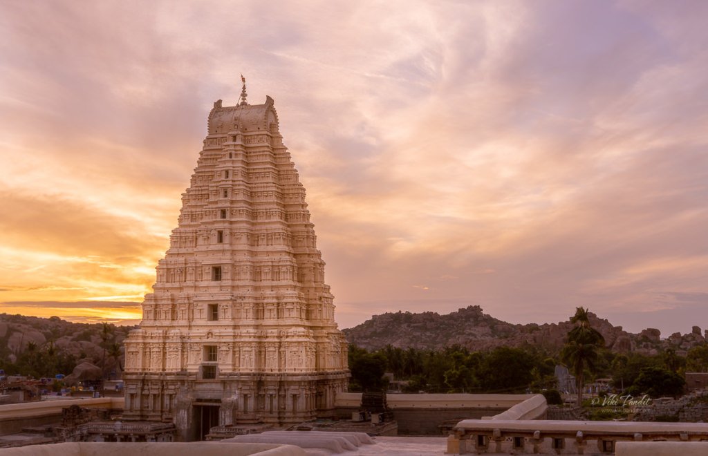
Monuments on Hemkuta Hill
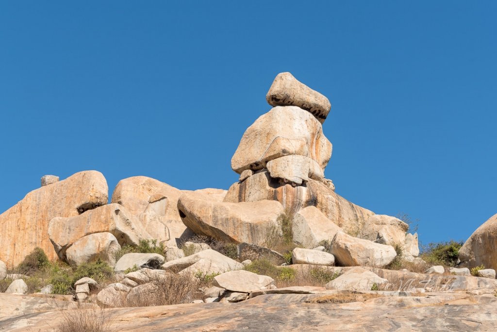
Idols of Kadalekalu Ganesha (Elephant God), on the Hemkuta Hill, Sasivekalu Ganesha, in another part, showcase how massive structures were created out of a single piece of rock. Parts of these temple complexes also contain numerous carvings of mythological importance.

The Hemakuta hill houses the most well-preserved pre-Vijayanagara and early-Vijayanagara temples of Hampi. This hill is sprinkled generously with a large number of temples, archways, and pavilions. The whole of the hill was fortified with tall wide stonewalls, the ruined remains of which can be still be seen.

These boulders date back to more than 3 billion years and are believed to be the earliest solidified rock on the planet. 

Read more about the monuments on Hemkuta Hill.

Virupaksha Temple

As we started our descent from Hemkuta Hill, we could see the Virupaksha temple complex. This temple predates the Vijayanagara kings and is still an active temple in Hampi. I was pretty tired by the time we reached Virupaksha temple. There was quite a crowd around and a few devotees were placing diyas on the road. It being Dusshera in India, they probably had some festivities planned for the evening.

Read more about the Virupaksha Temple.

We just watched the temple from outside. I had gotten thirsty and we had left the Water bottle in the car at the Balakrishna Temple. I tried calling the driver but the network was unavailable. We took a short walk on the Hampi bazaar street. On the left was a row of shops. I found a store that was selling mineral water apart from some other snacks. After taking in a few gulps we walked towards the auto/car parking area. We still didn’t have any phone network, so we hired an auto to drive us back to Balakrishna Temple. On reaching the car I asked the driver to take us to our last stop of the day, Vitthala Temple.

He told us that to reach Vithalla Temple we had to take a long walk along the Tungabhadra. it was only later we came to know that there is also a route where you can drive all the way to the Vittala Temple. On the way, we chanced upon another temple in ruins. It is one of the hidden temples of Hampi located beyond the Matanga hills. The location of the temple is secluded and off the more traveled path, the temple is much less crowded as compared to many other tourist attractions in Hampi.

We got down at Virupaksha Temple parking lot and walked back along Hampi Bazaar street. At the end of the street, there was a line of decorated steps leading to a monolithic Nandi statue.

River Tungabhadra

We asked a few locals and they guided us on the trail. After some time we reached a path made of stones parallel to the banks of the Tungabhadra river. The river at this point is forced into a narrow gorge, hemmed by granite hills. Monsoon had just ended but the river was still very calm. After walking for about 30 min we reached a beautiful spot on the banks of the river. Over the years, the flowing water has polished the rocks that border the river. The river was also known as Pampa in ancient times. We sat there for a few minutes enjoying the late afternoon and cooling our heels in the flowing waters of Tungabhadra. After some rest, we started back on the trail. Quite a few people were coming back on the same trail, so it wasn’t difficult to follow.

Achyutaraya Temple

The Achyuta Raya Temple was built in 1534 CE during the rule of Achyuta Deva Raya, one of the emperors of the Vijayanagara Empire. He came to power by succeeding his elder brother Krishna Deva Raya in the year 1529.

The main idol worshiped in the Achyuta Raya Temple is Lord Tiruvengalanatha which is, an avatar of Vishnu. The temple was initially known as Tiruvengalanatha Temple. However, later on, it came to be called after the king in whose reign it was built. Since then, it became widely known as the Achyuta Raya temple. The towers, pillars, and walls have exquisite carvings and ornamentation. Major parts of the temple are in a damaged condition. Although it is in ruins, the temple does not fail in grandiosity and its magnificence even today.

The principal shrine of the temple is located in the center of a pair of rectangular concentric enclosures. There are pillared verandas on the interior flanks of the two courtyard walls. The outer walkways are in a state of decay, collapse, and disintegration. The temple is distinctly visible from the top of Matanga Hill. It is at the end of the abandoned Courtesan Street.

On entering the inner court one can spot a chamber that is facing the porch leading to the central hall. There is a small shrine chamber that once sanctified an image of Garuda. The carvings are done on monolithic blocks of rocks. The statues and sculptures on the pillars reveal themes like Vishnu blessing an elephant, Krishna practicing his flute while the calves are watching this scene with interest, and infant Krishna dancing with a snake and holding it by the tail. There is a Mandapa, a marriage hall of the Gods, and the Goddesses for the yearly nuptials.

Dusk was almost setting in as we reached Vitthala Temple. Just before the Vitthala Temple, there is a monument popularly known as the King’s Balance. The stone frame is all that remains from the original structure that was supposed to work like a weighing scale. It is said that king Krishanadeva Raya, used to weigh himself here with gold, silver, and precious stones, and distribute it to the Brahmans on special days.

Vitthala Temple

The Vitthala Temple is Hampi’s crowning glory and a photographer’s delight. Vitthala is the Krishna avatar of Vishnu, worshiped in these parts as their cult deity. The temple is built in the form of a sprawling campus with compound walls and gateway towers. There are many halls, pavilions, and temples located inside this campus. It is one of the largest temples of that period, started under the patronage of Proudha Devaraya, also known as Devaraya II. He ascended the throne in 1422. and ruled up to 1446 A.D. Substantial portions of the present structure were added by Krishanadeva Raya during his 21-year reign.

Entry to the Vitthala Temple requires a ticket. The temple is built on a sculptured decorated plinth. The Sabha Mantapa (meeting hall) pillars are massive, carved out of single granite blocks. To the north of the Sabha Mantapa is the Narasimha Mantapa, where a pillar has the sculpture of Narasimha and its various other forms. The eastern hall of the Mahamandapa is the Hall of Musical Pillars. Each of these pillars is said to have generated music on tapping and are carved with figures of musicians, musical instruments, and dancers. However, it is off-limits to visitors now; since people used to break the pillars trying to get music out of them.

Two other prominent structures inside the complex are the Kalyana Mandapa (for marriages) and the Utsava Mandap (for festivals). The sky had become vividly purple and looked amazing with the silhouette of Anjanedri Hill in the background. We strolled around the temple grounds, talking and checking out the carvings. After some time we came out and walked towards the left of the temple towards what looked like another Mandapa. We sat there for a few minutes taking in the beauty of the place.

A one-day trip obviously does not do justice to all the monuments. Hampi is a photographic pilgrimage. We spent some amazing time at the Zenana Enclosure, Balkrishna Temple, and Hemkuta Hill but breezed past Lakshmi Narasimha Temple, and Kadalekalu Ganesha and Sasivekalu Ganesha Temples, Virupaksha Temple, Vitthala Temple, and a few others.

Even though the city is considered to be around 800 years old, recent excavations around Anegundi have unearthed archaeological artifacts dating back to the 3rd century BC. These findings show that the Vijayanagar area was densely settled for a long period even before the creation of the empire. The present buildings must have been left alone by the Mahomedan conquerors apparently on account of their utter insignificance – in comparison with the grand edifices which they destroyed, to leave no traces of their enemies.

The Hampi Group of Monuments was inscribed as World Heritage Site (WHS) by UNESCO in the year 1986. Fourteen monuments were covered initially in this inscription and today fifty-six monuments protected by the ASI are considered as World Heritage. Due to the recent jump in tourism and vandalism of this great city, UNESCO has listed it as a “threatened” World Heritage site. Mani was already planning to come back and so was I.

Visitor Information

Hampi is hot during summers and exploring even parts of the ancient city involves a lot of walking. I would recommend visiting between October to April and spend at least two days to truly enjoy the vast heritage of Hampi. Even if you want to explore alone, it is a good idea to hire a Guide, they will tell you the amazing stories behind the ruins. If you don’t know the story a ruin is just a ruin. 

If you can withstand a drive of 3 hours, there are a couple of interesting heritage sites near Hampi like Badami & Pattadakal that are wonderful places to enjoy more ancient architecture

What is the best time to visit Hampi?

It is a good time to visit Hampi during the monsoon season between July and September or during the winter months between November to February. If you are interested in catching up with some religious events, January-February is a good time to witness the legendary Virupaksha Temple Chariot Festival and the annual Purandaradasa Aradhana Music Festival at Vitthala Temple.

Admission Fees

Most of the areas around the heritage city are free to access. You will need to purchase admission tickets at Vitthala Temple and The Lotus Mahal.

Vitthala temple: Open between 6 am and 6 pm, the entry ticket for Indians and tourists from SAARC and BIMSTEC countries is ₹30 per person. For foreigners, the entry ticket is priced at ₹500.

Lotus Mahal: The entry fee of lotus mahal is ₹10 per person for Indians. For foreigners, it is priced at ₹250.

Night Trek to Kunti Betta

After the amazing experience of Savandurga Night Trek last weekend, I had to yield to this weekends Night Trek to Kunti Betta.

Legend has it that..

Kunti Betta consists of two rocky but easy to climb hills that towers over a picturesque lake. The nearest town is Pandavapura, a panchayat town in Mandya district, located approximately 130 km from Bangalore. It came into prominence during the Mahabharata period. It is said the Pandavas ended their exile of 14 years here in Pandavapura. It is also here that Bheema, one of the Pandava brothers slayed Bakasura, a demon who used to terrorize the local villagers. The Hills derive their name from Kunti, the mother of the Pandavas.

The Journey

The skies were much clear today. My pick-up point was at Central Silk Board at 11 p.m. and had a tough time reaching. I am surprised how basic transport services reduce drastically after 10 p.m. in  Bangalore. I mean isn’t Bangalore an IT Hub. How can basic transport services go off at 11pm. Its ridiculous!

It takes around a couple of hours to reach Pandavpura so some of us took the opportunity to grab a nap. Midway we stopped at a highway tea stall. Along the way we also crossed the Pandavpura Railway Station. We finally stopped at the base near a boarding school. I have forgotten the name of the school. This time we didn’t have a guide, why I realized later. Kunti Betta is comparatively an easier trek from what I experienced at Savandurga Night Trek. No steep faces, boulders strewn across with easy trails all the way to the top. The only hindrance were some thorny bushes.

The Trek

Situated at a height of around 2900 feet above sea level, Kunti Betta is one of the relatively easy treks.  We reached the base of Kunti Betta at around 2 am. This time around the Ishan & Salwat from Get Beyond Limits had an alternative route planned for us. There are certain things I love about Get Beyond Limits. They always do a good reckon of the place they are going to take trekkers and plan everything early on. Not many use this route, bit it was certainly more challenging. The first beautiful rock we reached was the Croc rock, with the rock face protruding out in the shape of a crocodile’s head. I had my new trekking shoes and I was amazed with the grip I was getting. Boo Woodlands! The night was pitch black. During the climb there were moments I would just sit back & stare at the beautiful starry skies. Luckily the clouds stayed away for  a few hours.

We reached the top of a small hill in an hours time. We took a breather there and were off again towards the peak. All around I could still see lights from the town and far off places. I wonder how it would feel if all lights went out for a few minutes. Along the way there were areas with open spaces, perfect for setting up a camp. We reached the peak in another hour. By this time the clouds had gathered again and the stars were gone. From the top of this hill at night, the Kunti Kund lake looked mesmerizing, slightly hidden from view by the other hill. I had my tripod and was able to get a long exposure shot of the amazing scene.

Invalid Displayed Gallery

It was almost dawn, but we still decided to have a bonfire. Within a few minutes the Sun started to rise. It was hard to see with all the clouds, but the sky went into a fantastical gradient of orange and purple. Everyone was taking selfies 😉 Unfortunately selfies don’t do justice the the breathtaking scene they were in.

As the first lights of the Sun started to clear the darkness, we went towards the “Parikrama” rock. One has to jump over to reach this place. Even though I was in better shape on this trek, I was still far away from taking on this challenge.

Invalid Displayed Gallery

The Descent

By 8 a.m. we were ready to descend. Downhill was quick and easy. I find it fun to look for faces & shapes in clouds. As we descended, I went past a few boulders that I think were in the shape of an ape’s face. Ishan threw us a couple of challenges along the way. He is always looking around egging us on to take on new challenges. At the base we headed towards the Kunti Kund lake on the far side.

We passed some freshly planted sugarcane fields. I recalled having fresh sugarcane juice right from the fields when I used to visit my Grandpa in the village long time back when I was a kid. We reached the lake in about 30 mins. The breeze was almost blowing us away as we reached the banks of the lake. Some of the more enthusiastic trekkers went into the water. It wasn’t more than knee deep at the edges.

After spending some time at the bank of Kunti Kund, we trekked back to the town where we had a sumptuous breakfast lined up. I heard the town also has a few Jaggery factories. We had a scheduled visit to a sugarcane factory but everyone got tired and we skipped it.

The ride back to Bangalore was sleepy. I dropped off at Jayadeva at 2pm and took an auto ride home.

I would love to come back to this place again sometime when we have clear skies. I also wonder how beautiful it would look with the sun descending on that lake. But that’s for another day. Not too far in the future, I hope.

Indispensables

  1. 2 Liters of Water. Very essential
  2. Torch or a head lamp (only for night treks) It is always handy to carry one battery operated and one dynamo torch as a backup in-case batteries die out.
  3. Rubber Sole Shoes
  4. Pain Spray for sprains etc
  5. Basic medical supplies
  6. Raincoat or poncho

Night Trek to Savandurga

Savandurga is an amazing place for a photo-op… but Whoa! the fort of “death” and that too on my first trek!!

History of Savandurga

Located at a distance of 64 km west of Bangalore, Savandurga is reputed to be the highest monolith in Asia. It comprises two looming granite hills, Karigudda, the Black Hill and Biligudda, the White Hill, both around 4000 feet tall. Historically, the hills find a mention in the records of the Hoysala period in the 13th century. In those times it was referred to as Savandi hills. Later during the reign of Hyder Ali, this hill served as a fort prison from where it was said there was no escape but via death. Since then the locals began referring to it as “Mrutyu Kupa” which vaguely translates to “the fort of death.”

The nearest town to Savandurga is Magadi, known for being the birthplace of Kempe Gowda who is kind of looked at as the founder of the city we now call Bangalore. More recently, the hills have been featured in the making of David Lean’s movie A Passage to India.

The Journey to Savandurga

I was going on this night trek to Savandurga along with a trekking group. My pick-up point was at Central Silk Board at 11 p.m. It was my first trek around Bangalore and I was duly very excited. The tempo bus was waiting, filling up as more and more trekkers trickled in. We hit the road by 11:30 p.m. I had been searching for good trekking groups for over a year and this is the first team that impressed me even before I started on the trek. The other trekkies joining us from various parts of bangalore got introduced to each other on the bus during the ride. Most trekkers came in groups – friends from office or were couples. I was the only loner, but I had my camera, that more than made up for it.

I am new to Bangalore but I could vaguely identify the route towards Savandurga, since it goes along the same route as I had taken when I had been to Manchanabele Dam just a few weeks before. Once we left the city behind, the stars were much brighter, a rare sight during monsoon around Bangalore.

Savandurga Forest

Savandurga is surrounded by a thick forest of scrubs, said to harbor around 60 different tree and 119 shrub species. The hills are also home to the endangered Yellow-throated Bulbuls. The road became a bit bumpy as we entered the Savandurga Forest. On the way we passed the Manchanabele Dam. Created by the waters of the Akravathy River, Manchanabele Reservoir itself is a lovely place from where you can get an enticing view of the Savandurga Hill.

We reached the base of the hill near the Narasimhaswamy Temple at around 1 am. Were were going to conquer Biligudda tonight! It is a relatively easier climb compared to Karigudda, which requires permission to climb. We got an energy pack from the organizers comprising a juice tetra-pack, an energy-bar and a pack of biscuits.

Trekking to Savandurga

Within a few minutes our local guide, Anna, came running with his huge torch. He is a local resident and knows his way around the hills. We started the climb at around 1:15 am.

Trekking in Savandurga can be thrilling as well as challenging as I discovered. It’s a smooth monolith and at certain points, very steep. Luckily we didn’t have rains and the trail was dry. I did though make a big mistake being in my Woodland’s. It’s a bad idea to trek in Woodland shoes. They are heavy and not good at getting a grip on the rocky surface. One should always get a rubber sole shoe and preferably one that is light.

We took a break midway through the climb. The clouds were flowing by us and it was time for some ghost stories. During story-telling, Ishan shared with us his experience of when he and his friend landed up in Bhangarh, a ghost village.

Sitting on the cold rock, I could see the lights from the nearest town of Magadi. Suddenly out of nowhere, a thick cloud enveloped us. In the haze, the light from our torches glowed like beams crisscrossing each other. It was an unforgettable experience. We spent a few minutes there and started again.

After some 45 minutes into the trek, we reached a makeshift shed.  There is a small natural pool beside the Mantapa. We took a break here and had a nice and warm bonfire going.

Some of the guys took a quick nap. I was too excited to even think about sleep. I scouted around for places where I could get a good view of the sunrise.

By 5:30 a.m everyone was wide awake and ready to move on for the final climb. We hit dawn at around 6 a.m. The view was ethereal. It appeared we could just jump and snatch away a bit of the clouds.

The sun was hidden behind the heavy clouds so we weren’t able catch a glimpse but at some places the rays would somehow peek through. As light improved it also revealed a small pond near our shack.

Savandurga Peak

There was a little drizzle and my shoes had become very slippery. The second part of the trek to the top of Biligudda was not very tough and we were there in around 30 mins.

We sat there basking in the conquest. At the top of Biligudda is a small shrine dedicated to Nandi, Lord Shiva’s sacred Bull. This shrine/tower was commissioned by  Kempegowda in the 17th Century.

Beside it there is a broken rock structure that is referred to as the Superman Rock. Why? well according to GBL anyone who stands on that rock looks like a superman 🙂

We stayed at the peak for an hour, immersed in the amazing beauty of mother nature. As the Sun started to become harsh and we started the descent at around 8 am. GBL has a “No Littering” policy, so no one is allowed to litter, beyond that they also gave us an option to carry back any plastic garbage left behind by irresponsible trekkers to Bangalore. We collected some 4 big bags of tetra-packs and soft drink bottles. While descending, we took a detour and some of the guys/gals did some rock climbing. I didn’t. Rock climbing is not my thing, so I try to skip as much as I can.

The Descent

While climbing down we passed a fort wall, almost in ruins. It was only now that in the bright light, I was able to see properly the steepness of the hill. At night when we were climbing it didn’t feel so steep. We reached the base in an hour. I was exhausted. At the foothill there is a village by the same name.

From what I hear, Savandurga hills are frequently visited by pilgrims round the year, who come to visit the Narasimha Swamy and  Savandi Veerabhadreshwara Swamy temple situated at the foothills. The Narasimhaswamy Temple was abuzz with people paying respects and praying for happiness.

Just beside the temple, the guys from GBL had arranged for some delicious Tatthe Idli, a local delicacy for breakfast. I loved it and possibly ate a bit too much 🙂 . We had some coffee, took some rest and headed back to the bus. On the way back we stopped for a few minutes at the Big Banyan Tree which is near to 400 years old. Some monkeys came down to check my camera gear and went back annoyed when I didn’t comply 🙂

Thanks for reading! It was my first night trek and it was fabulous.  I do have a sense of achieving something beyond my limits on one of the jewels of the Deccan plateau. The trek is relatively easy and photographers looking for a easy outing amidst mother nature are going to love it.