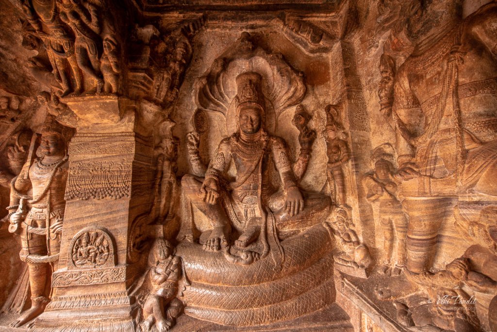
Shades of Virupaksha Temple

This was my third visit to Hampi, but the first time that I drove myself to the historical city. Hampi sits on the banks of the Tungabhadra river in the ruins of the ancient city of Vijayanagar, capital of the once flourishing Vijayanagara empire.

The road to Hampi is pretty straightforward. I took the NH48 from Bangalore and then slid into NH50 near Chitradurga. The NH50 is under major repairs but its still faster than any alternative routes.

On the way we passed the Tungabhadra reservoir. The national highway leads directly to the town of Hospet, from where we drove into Kamlapur, where our hotel was located.

Clark’s Inn

We were staying at Clark’s Inn for the duration of our stay in Hampi. Even though we had an amazing time at the Hyatt Hampi in 2014, I reserved this hotel mainly because I wanted to stay closer to the UNESCO site. Staying at Clark’s Inn reduced my travel time to reach the ancient monuments from 40 minutes to just over 10 mins.

Clark’s Inn is a decent place to put up for a few days. The food is nice and the staff hospitable. They also have a small swimming pool. But the parking is a bit of a concern since it lies in the basement and the lane leading to it is quite narrow. On the bright side, they do however have valet services to help out visitors.

History of Virupaksha Temple

Like I mentioned before, I have been to Hampi multiple times but this time I came with the sole purpose of capturing the iconic Virupaksha temple (храм вирупакша) at different times of the day.

While discussing the monuments at Hampi, the first thing that comes to mind is the contribution of the Vijaynagara Empire. However the Virupaksha – Pampa sanctuary existed well before the Vijayanagara capital was located here.

Virupaksha Temple has been a most prominent center of pilgrimage at Hampi for centuries with earliest records dating from 689 CE when it was known as Pampa Tirtha after the local river God Pampa. The temple is fully intact among the surrounding ruins and is the only active temple in all of Hampi. The temple is dedicated to Lord Shiva, known here as Virupaksha.

The shrine dedicated to Shiva was established on the banks of the Pampa (Tungabhadra) river sometime in the 7th century, thus making it older than a thousand years. It is debatable whether the initial temple was actually the structure that is still on top of the Hemkuta Hill known as Mula Virupaksha Temple. By logic it should, since temples are generally created on the top of hills. By the mid 7th century the temple had already become a revered Saiva pilgrimage with the Saivas taking up settlement on the Hemkuta hill just beside the temple.

In those times Hampi was known by the name Pampakshetra. It is not clear when but the growing popularity of the temple might have resulted in the creating of the larger Virupaksha Temple near the banks pf the river Pampa (Tungabhadra).

The mythology surrounding Virupaksha Temple

The Tungabhadra river of today was in ancient times known as the river Pampa. The Skanda Purana mentions Pampakshetra as saktipitha, describing it as the abode of the goddess Pampa otherwise referred to as Parvati. According to local myth, Pampa, the daughter of Brahma, mortified herself here to gain the hand of the Lord Shiva. Multiple references to Pampakshetra can be found in records between the 7th to 14th century, overlooking the banks of the Tungabhadra, which currently include Hampi and Anegundi. Several inscriptions can also be found at the temple itself dating back to the 9th and 10th centuries. 

Time passed and what started as a small shrine grew into a large complex under the Vijayanagara rulers. Domingos Paes (1520–22 AD) whose records provide valuable inputs into life during the Vijaynagara reign mentions that inspite of the numerous temples in the vicinity, Virupaksha temple was the one which the people held most veneration for.

The Vijayanagara rulers, in the middle of the 14th century, initiated the blossoming of native art and culture in the region. Though most of the temple buildings are attributed to the Vijayanagara period, there is ample evidence indicating to additions that were made to the temple in the late Chalukyan and Hoysala periods. When they were defeated by Deccan Sultunate in the 16th century, most of the wonderful decorative structures and creations were systematically destroyed. However they were not able to destroy the religious sect of Virupaksha-Pampa. Even after the anhilation of the city in 1565, worship of Shiva persisted throughout the years and continues even today.

Breaking dawn at Virupaksha Temple

On my first day in Hampi, I woke up at break of dawn and drove down to the temple. By the time I reached the parking lot near the temple the sky was already glowing in blue and the stars were beginning to fade away. The parking was mostly deserted.

One of the best spots to catch the sunrise is from the Hemkuta Hill. Its an easy hike up towards the western side of the hill. By the time I took my position on the Hemkuta hill, the Sun was ready to cast its blessings on Hampi and I was ready with my tripod to capture its glory.

I set up my composition on the main gopura, which is the most ornate structure of the temple. The main gopura or temple tower is called the hiriyagopura or the chief tower. It has a brick superstructure and a stone base. Supervised by Devaraya’s minister Proluganti Tippa, the nine-tiered eastern gateway is the largest of the gopuras raised by the Vijayanagara kings.

Light changes pretty fast in these moments and within minutes the gopura was flooded with light from the Sun.

Daytime at Virupaksha Temple

By afternoon the sky had changed to a brilliant blue. The devotees were streaming in. Being a weekday, it was comparatively less than the crowds on weekends.

At present, the main temple consists of a sanctum, three ante chambers, a pillared hall and an open pillared hall. It is decorated with delicately carved pillars. The smaller eastern gateway leads to the inner court with its numerous smaller shrines. The hall of the main temple is believed to have built under the patronage of Saluvamantri, a minister of Sangama Mallikarjuna (1447–1465 AD).

Another gopuram towards north known as the Kanakagiri gopura, leads to a small enclosure with subsidiary shrines and eventually to the river Tungabhadra.

Krishnadevaraya, the most famous kings of the Vijayanagara Empire was a major patron of this temple. The most ornate of all structures in the temple, the central pillared hall is believed to be his addition to this temple. So is the gateway tower giving access to the inner courtyard of the temple.

It is recorded that Krishnadevaraya commissioned the open air hall in 1510 AD to mark his accession. Inscriptions on a stone plaque installed next to the pillared hall explain his contribution to the temple.

Nights at Virupaksha Temple

Sun is strong in Hampi. Evenings brought relief to my parched body. It also brought with it a magical glow to the surroundings. The sky went all red for a moment. The guard wouldn’t allow me to set up my tripod so I took this handheld.

After this we walked out of the fenced area where I set up my tripod to capture the one below. By that time the sun had already set but it left behind a beautiful blue sky.

After catching the temple at sunset, I made my way towards the wide street in front of Virupaksha, situated between the eastern gate of Virupaksha and the northwestern foot of the Matanga hill. Domingos Paes describes it as – a very beautiful street with beautiful houses with balconies and arcades, sheltering pilgrims that come to it, and with houses for the upper classes. He also mentions that the king too had a palatial residence in the same street.

Festivals at Virupaksha

In the month of February the annual chariot festival is celebrated here. Nicolo Conti, the first European visitor to Vijayanagara (1420–1421 AD), refers to two chariots which carried idols through the city. Richly adorned women or courtesans accompanied the procession stinging hymns in praise of the lord. Poet Ahobala, the author of Vasantotsava Champu, also refers to the two chariots: one taken out by the Brahmins and the other by the merchants or shudras.

Interestingly, the Virupaksha chariot festival has been continued ever since it was introduced in the fourteenth century and neither the fall of the empire nor the destruction of the capital in 1565 AD seems to have affected its popularity or practice. To date, the largest gathering at Hampi is witnessed during the chariot festival of Virupaksha held every year in March/April as per the local calendar.

Renovations

There have been major renovations which included painting the towers of the north and east gopura. When I was here a few years back the gopura were in white but I see a beige paint now. It is also heartening to see that ASI has stayed away from applying plasters to stone carvings like they did at Kailashanthar temple in Kanchipuram, which actually makes them look ugly.

I leave you with the last image of the day: Virupaksha captured from the steps of Matanga Hill at night.

Thanks for reading. Please leave me a comment if you liked the post or follow my story as I revisit the monuments on Hemkuta Hill.

Blue waters of Pangong Tso

The journey to Pangong Tso starts from Nubra Valley. We had a lovely day among the sand dunes of Nubra.

Drive from Nubra to Pangong Lake

The drive from Nubra to Pangong takes you through a wide varied landscape. The Shyok river stays with us for most part of the ride.

Once the river leaves us and goes on its own way near Durbuk, the road too becomes quite bad. In fact, at certain points, it was almost impossible to make out where the road was.

After a few hours we reached the Changthang Cold Desert Wildlife Sanctuary. This is the only place where you can see some vegetation. I caought some Pashmina goats grazing happily in the meadows

This little guy almost head butted me… he was probably taking care of the herd.

You can also find some horses lazying around in the cool breeze.

The roads near the santuary are well maintaned. The landscape also changes to a more pleasant view.

And then we see the first views of the Pangong Lake.

Pangong Viewpoint

We were staying in Spangmik village, but we first hit the popular viewing point, so we stopped there for a few minutes. It was around 2 pm and it was perfect to capture the beautiful lake in the brilliant light.

We moved around the edge of the huge lake taking shots of the crystal clear waters of the lake.

You can find Yaks available for rides if you want one.

You can see the changing colors of the water in the lake. It is greening towards the edges and more blue as you move your eyes towards the center.

After capturing some really amazing photos of the lake we moved on towards Spangmik village.

On the way we took more pictures of the mesmerizing lake.

Just before reaching the village, we passed an area with wide open space in front of the lake. Tsering, our chauffeur informed us that he will be taking us there in the evening, which is another wonderful place to enjoy the breathtaking scenery.

By 3 pm we had reached our lodgings at Spangmik.

It was May and still the mountains tops were covered in Snow.

After refreshing ourselves, we were ready for the second round. As promised Tsering took us to this lovely viewpoint from where you could capture the lake in its full beauty.

Mani modeled for me as I captured some amazing potraits. It was only 4 pm but the breeze had picked up and it was lethally cold. I was somewhat safe in my blazer, but Mani was having a tough time in the cold.

I quickly captured a shot of us before the cold really started to hurt.

With the Sun behind the mountains, the lake had turned into a deep blue color.

Shivering from cold, we hurried back to our tents. The tents lie at the edge of the banks. After a warm tea, we walked around in the evening.

The strong chilly breeze drove us inside the comfort of the tent. The night was extremely cold and even though I want to capture the stars over Pangong Tso, my body was too cold to come out.

In hind-sight, I should have stayed back for a day, but with a tight schedule, we had to move back to Leh the next day.

Next Morning…

The light is extremely bright in the mornings, so carry your eye shades.

We passed the lovey viewpoint we stopped at the day before for a few minute, but the light was too strong to capture good photos.

By 10 pm we are back on the road to Leh.

Dunes of Nubra

Nestled amidst the majestic peaks of the Himalayas in the northernmost region of India, Nubra Valley is a surreal and enchanting destination that captivates a photographer’s heart. Situated at an altitude of around 10,000 feet above sea level, this high-altitude cold desert boasts a landscape characterized by sweeping sand dunes and rugged terrains.

The valley lies between the two well-known Himalayan mountain ranges of the Karakoram (on the North), and the Ladakh (on the South). From Leh, we drove to Nubra across the Khardungla pass. The drive to the valley, spans around five hours, through one of the the world’s highest motorable roads.

Each twist and turn on the drive offers a new perspective of the desert’s beauty. At some points, the roads are treacherous but the awe-inspiring mountain vistas makes one ignore all the bumps on the road.

After the captivating drive through the mountains, we stopped at a dhaba near Khardung. The meal comprised steamed rice and dal along with some vegetables. Eateries are separated by long intervals so make sure you carry some biscuits or other beverages for the trip.

Just before we entered the valley, we came across some locals offering services for Quad biking. I have not driven one yet but a ride through this vast expanse of the desert must be an exhilarating adventure for those interested. The powerful hum of the quad bike engine echoed against the sandy dunes as we drove past them. The freedom to traverse the open desert, with its golden hues stretching as far as the eye can see, is an unmatched experience.

Diskit Monastery

Just before reaching Hunder, we took a small detour to Diskit Monastery, also known as Deskit Gompa. The monastery stands as the oldest and largest Buddhist monastery in the enchanting Nubra Valley. Constructed in the 14th century by Changzem Tserab Zangpo, a devoted disciple of Tsong Khapa, the founder of the Gelugpa (Yellow Hat) sect of Tibetan Buddhism, it serves as a sub-gompa to the Thikse gompa in Leh. Poised on the precipitous cliffs, the monastery exemplifies the Tibetan box structure, crafted from a blend of stones, mud, and wood.

Within its sacred walls, ancient scriptures, sculptures, murals, frescoes, brocades, and thangkas are housed, each narrating a tale of spiritual heritage. The Mahakali temple, statues of Tibetan deities, the Sakyamuni Temple, and the prayer hall add an air of mystery to this sacred sanctuary.

Near the historic Diskit monastery, the renowned 106-foot-tall statue of Maitreya Buddha stands as an iconic presence. Inaugurated by His Holiness the Dalai Lama in 2010, the enigmatic statue serves as a profound symbol of global peace and a vision for a future free from warfare.

Positioned on a hilltop, it offers a mesmerizing 360-degree panoramic vista. The bird’s-eye view unveils the picturesque Diskit Village in Nubra Valley, leaving us in awe of the vastness and tranquility of nature.

A quick 20-minute drive from Diskit Village transports us to the extraordinary realm of Hunder. Situated about 10 kilometers from Diskit, Hunder unveils a fascinating juxtaposition of snow-capped mountains and sand dunes, making it the sole location in India where these contrasting landscapes coexist in a single frame.

We were staying at the Hunder Sarai. The camps are surrounded by barren cold mountains and just about a 10-minute drive to the dunes. Hunder does have a mobile tower, but the network connectivity is not good. In between the gardens, outside slows a stream of crystal clear water. After a quick change of clothes, we directly drove to the dunes.

On the way, we noticed some camels making their way towards the dunes as well. The double-humped Bactrian camels are a distinctive feature of Hunder. It is said that Hunder used to be a crucial stop on the ancient Old Silk Route and these camels were brought in from Central Asia. In fact, it was still a trade route between Yarkand (present-day Xinjiang, China) and Leh, the capital of Ladakh, till the closing of borders in 1949 CE.

A camel safari atop these furry, double-humped creatures, navigating the silver or white sand dunes, becomes a once-in-a-lifetime adventure. The panoramic view of colossal mountains against the intensely blue sky, alongside the pristine white dunes will be etched in your memory for life.

The desert’s extremes are felt with the scorching sun in open areas and a sudden chill in the shade, necessitating layered clothing, sunscreen, and of course sunglasses. I would recommend staying in tents as the nights though chilly, promise a spellbinding display of the starry sky over the village.

Despite its arid and challenging conditions, Nubra’s cold desert boasts a unique ecosystem adapted to the harsh environment. Nomadic communities, such as the Changpas, have traditionally herded livestock in this challenging landscape, showcasing the resilience of life in the cold desert.

The Nubra region is the northernmost of Ladakh and in fact of all of India. It is fed by two main rivers: the Shyok and the Siachen. Both originate from the Siachen glacier but are on either side of the western Karakoram Range.

The climate of the regions is extremely harsh with scanty rainfall along with less moisture contained in the air. The minimum temperature in winter drops to -30 °C, and the maximum temperature is around 25 °C in the summer. In Nubra valley, the source and supply of water from glaciers is the only option for irrigation purposes, and portable water which is flowing through the two main rivers such as Nubraand Shayok, originates from the Siachen glacier and Remo glacier, respectively.

As the day passes, the winds pick up and create a kind of sandstorm. The sand dunes of Nubra are situated at the confluence of the Nubra and Shyok Rivers, creating a surreal desert landscape surrounded by majestic mountains. The dunes, predominantly composed of fine-grained sand, are sculpted by the relentless forces of wind, carrying sand particles from the riverbeds and depositing them in the valley. This continuous process shapes the dunes into undulating patterns, creating an ever-changing canvas of nature’s artistry.

The evening was cloudy and the sand kept blowing into our eyes. The weather is not friendly here and it gets pretty cold once the Sun hides behind the clouds. With every hour, the strong breeze keeps blowing the fine sand, reshaping them into new shapes. Even though the sand was harsh, we did get some wonderful photos. The wind whistles past, carrying the essence of the arid wilderness, while the rhythmic dance of the dunes creates a visually captivating spectacle.

Time passed quickly and soon the Sun was setting behind the mountains. The Nubra region is well known for its role as a gateway between the Indian subcontinent and Central Asia in modern times.

The voyage to Diskit Village in Nubra Valley is an exceptional experience, both literally and metaphorically placing me on top of the world. Traversing through Khardung La, the pass that once held the distinction of being the world’s highest motorable road at 18,380 feet, I found myself amidst unparalleled beauty. Presently, Umling La claims the title as the world’s highest motorable road, reaching an elevation of 19,300 feet in Ladakh.

The clear and unpolluted skies of Nubra Valley offer breathtaking views of the night sky, making it an ideal location for stargazing amid the tranquil desert setting.

Ladakh stands as one of the most stunning yet environmentally delicate regions in our country, emphasizing the need for tourists to be mindful of their impact on the area. The Ladakh region boasts breathtaking beauty with its cold desert landscape, yet it remains sparsely populated. It welcomes tourists from April to September, primarily during the summer months. While the improved infrastructure has brought economic benefits to the locals, the surge in tourism has raised concerns among environmental experts. Many argue that unregulated tourism poses a potential threat to the ecologically sensitive region.

Next, we move on to Pangong Tso, renowned for its stunning natural beauty. Surrounded by towering snow-capped peaks, the lake’s crystal-clear blue waters create a mesmerizing and picturesque landscape that is said to be a photographer’s dream. Thank you for taking the time to read my blog! Your interest and engagement mean the world to me. If you have any thoughts, comments, or questions, I’d love to hear from you.

Tourist Information

An Inner Line Permit (ILP), which can be acquired at the District Commissioner’s office in Leh, is required for tourists, Indians, and foreigners alike. People are required to check in en route and must provide photocopies of the permits to be deposited at each checkpoint.

Altitude sickness is a serious health concern for people not previously used to high altitudes. Prophylactic altitude-sickness medication such as Diamox may be necessary for some as there are no emergency medical facilities to treat altitude sickness along the route.

The road is closed from approximately October to May due to snow and is often subject to long delays due to traffic congestion on narrow one-lane sections, washouts, landslides and road accidents.

Road to Khardungla Pass

Ladakh is the highest altitude plateau in India. It is situated in the state of Jammu and Kashmir, bound by two of the world’s highest mountain ranges, the Karakoram in the north and the Himalayas in the south.

Khardung La is a mountain pass in Ladakh that serves as the gateway to the Shyok and Nubra valleys from the city of Leh. Though we write it as Khardung La, the local pronunciation is more like “Khardong La” or “Khardzong La.” The word La means pass while Kharzong means castle. I am not sure how the combination of these words were used to name this mountain pass.

Ride to Khardungla Pass

We were staying at the Shaolin Guest House in Leh. Leh is the largest settlement in Ladakh. It is a town of modest bazaars and winding streets, hemmed by rugged hills. A few of the main attractions are the Shanti Stupa, Namgyal Tsemo Gompa and Leh Palace. These places lie quite close to each other and can be visited in a single day.

We were leaving for Nubra Valley. Tsering, who was our designated chauffeur for the trip was at the gate exactly on time to pick us up for the long ride to Nubra Valley via Khardung La. The 150-km journey from Leh to the Nubra Valley includes some of the most diverse and exhilarating topography in the world, and its high point (both literally and metaphorically) is the Khardung La.

As we drove into the mountains, the air began to feel chilly. Due to the high altitude of Ladakh, the climate is very cold and the air is very thin, which in turn makes the heat of the sun extremely harsh. I don’t think I ever saw Tsering without a thick layer of sunscreen on his cheeks.

The geographical location of Ladakh ranges from 2,750 m high at Kargil to 7,672 m high at Saser Kangri in the Karakoram Range. The average height of the plateau is around 3,000m, and the numerous motor-able high altitude passes, such as Khardung La, Changa La, and Thaglang La allow for the region to be connected albeit during the summer months.

The motorway was built in 1976. It was opened to public vehicles much later in 1988. But the history of this road is much more ancient. Traders of the Silk Route, which developed in the pre-Christian era used the pass to travel between Leh and Kashgar in Xinjiang province of China. The 2000 meter climb to the pass provides thrilling panoramic views of the Zanskar Range beyond the Indus Valley and towards the Karakoram.

Khardung La is about 40 km by road from Leh. There are two bases on either side of Khardung La – North Pullu and South Pullu. The first 24 km, as far as the South Pullu check point, are paved. From there to the North Pullu checkpoint about 15 km beyond the pass the roadway is primarily loose rock and dirt.

Khardung La Viewpoint

The journey unfolded along perilous yet picturesque routes, with glacial snow flanking the roads and majestic, snow-covered mountains reaching towards the enchanting blue sky. The sheer ecstasy I felt during the drive is a sentiment shared by travelers globally who dream of navigating Ladakh’s roads by car or motorcycle. Gratitude extends to the Border Roads Organisation (BRO) and the Indian Army for their unwavering dedication to maintaining these roads, turning the dreams of many, including ours, into reality.

The elevation of Khardung La is claimed to be 5,359 m (17,582 ft). Earlier it was miscalculated to be around 18380 ft, which has now been corrected using measures from various other GPS surveys including SRTM data and ASTER GDEM data.

Maintained by the Border Roads Organization (BRO), the road is open to tourists all year round, but even now in the summer months, we could see icicles hanging along the sides from the rock faces. We stayed at the viewpoint for about 20 minutes and towards the end of the stay I could feel the dizzyness coming over me. We left soon afterwards. In fact a signboard nearby discourages tourists from staying beyond half an hour at this place.

A few minutes after the viewpoint, the roadsides were completely covered in snow. It was biting cold outside. In olden times the Ladhakis used to refer to India as Gyagar (gar or kar: white, ‘where people wear white clothes’). Here ‘white’ signifies the difficulties of living. For them life appeared more grim on the Tibetan plateau while they had always heard of warm and pleasant life in the Indian plains. Experiencing this level of snow in summer I can totally understand their hardship living in these cold mountains.

Towards Nubra Valley

From North Pullu into the Nubra Valley, the road was very well maintained.

As we descended we witnessed the first views of the Shyok river emerging from the eastern side of the Karakoram and flowing north– south before it takes a westerly course to join the Nubra river. In contrasting terms Nubra Valley means a valley of flowers while the Shyok river that flows into it means the ‘River of death’

An hour’s drive downhill from Khardung La leads to the first stop in Nubra called Khardung, a small village in a sandy flatland. We took our lunch at the village. Nearby some wild asses were busy munching on the rare green grass. This was our first view of any greens since leaving Leh.

Soon after, at Tirit, the road bifurcates: one takes you to the valley of the Shyok river which has the towns of Diskit and Hunder, with a magnificent high-altitude desert between them; and the other to the green valley of the Nubra river, towards Sumur and Panamik.

As we got closer to Hunder, the weather changed drastically and we were surrounded by sand from the cold desert. The skies had turned ominously gray, but we moved on excited and looking forward to our next stop: Sand dunes of Nubra.

Tourist Information

An Inner Line Permit (ILP), which can be acquired at the District Commissioner’s office in Leh, is required for tourists, Indians, and foreigners alike. People are required to check in en route and must provide photocopies of the permits to be deposited at each checkpoint.

Altitude sickness is a serious health concern for people not previously used to high altitudes. Prophylactic altitude-sickness medication such as Diamox may be necessary for some as there are no emergency medical facilities to treat altitude sickness along the route.

The road is closed from approximately October to May due to snow and is often subject to long delays due to traffic congestion on narrow one-lane sections, washouts, landslides and road accidents.

Finding peace at Shanti Stupa

The unique beauty of Ladakh lures visitors from all across the globe. The union territory is geographically located in the westernmost extension of the Tibet plateau. Its name ‘Ladakh’ literally means “the land of passes.” The capital city, Leh, hosts the only airport. During the winter months, Ladakh is completely cut off from the rest of the country.

As summer approaches, tourists queue up in hoards to lose themselves in the serenity, tranquility, and spirituality of this desolate world. Also known as “Little Tibet” the city is known for its colorful culture and rich traditions of Mahayana Buddhism that still flourishes in the purest form in this region.

Shanti Stupa is one of several must-visit destinations in Leh. Surrounded by lofty mountains it has a special place in the cultural history of Ladakh. This white-domed Stupa on a hilltop in Leh was conceived by Japanese Buddhist Bhikshu, Gyomyo Nakamura as part of the Peace Pagoda mission.

Walk to Shanti Stupa

We had spent the earlier part of the day exploring Namgyal Tsemo Gompa and Leh Palace. All the walking had left us tired. We took a brief rest at the Shaolin Guest House, and then towards early evening, left for the peace pagoda.

Shaolin Guest House lies a couple of kilometers east of the Shanti Stupa. We walked down Sankar Road and then onto the Shanti Stupa Road. The walk is not difficult but it is not recommended for tourists coming from the plains as they might experience breathlessness because of the high altitude.

It is advisable that you take the first day off and just relax. It will help your body to acclimatise to the thin air in Leh.

Midway through the walk we were greeted by the picturesque Poplar trees. With its towering height, the Poplars stand distinctly in the landscape of Leh. These Poplar trees are said to mature very quickly growing up to 8 feet in the very first year. In the barren desert with almost no vegetation, the brilliant green trees are a sight for sore eyes. On the way, we passed by many small single-floor houses, some made of bricks and some of mud. The boundary of these dwellings are marked with medium-height ash-colored brick walls.

As we reach the outskirts of the city, the road starts to go uphill and the houses gradually disappear. The evening was breezy and we didn’t feel any discomfort hiking up the hill.

The Shanti Stupa road would be the easiest way to reach the Stupa. The motorable road leads right up to the gates of the Stupa. One can also reach here by climbing near-500 steps from the opposite side of the hill but in my opinion, it is not a recommended route for the unfit.

It was 7 pm by the time we reached the entrance of the Stupa. The Sun had hid behind the mountains but the light was still great. Situated on the hilltop at Changspa at a height of 4267 meters, the Stupa provides wonderful panoramic views of the surrounding mountains.

Buddhism in Ladakh

It is said Buddhism penetrated Ladakh during the time of Emperor Ashoka in around 204 BC. But even before the reign of Ashoka, the Arhat Majhantika blessed these lands with his visit and prophesied this region becoming a stronghold for the Buddhist religion in the Himalayas. Ladakh was in those times known as Mar-yul (Red Land).

It cannot be denied however that it was during Ashoka’s reign that Buddhism spread rapidly and took a stronghold in this part of the world. The indigenous community which were mostly nomadic and lived off meat at that time, gradually absorbed the concept of vegetarianism that is still followed today.

The reign of Ashoka also introduced the religion in Japan. The teachings of Buddha aroused new consciousness in the people of Japan and thus rose Todaiji, the greatest of the Buddhist temples in the world. And this brings us to the Shanti Stupa which stands for Leh as a mark of the friendship between two countries connected by a religion of peace.

History of Shanti Stupa

The idea of Shanti Stupa has its roots in a vision conceived many years before by Nichidatsu Fujii. Nichidatsu Fujii [1885-1985] more commonly known as Guruji, was the founder of the Buddhist religious order, Nipponzan Myohoji, which is dedicated to working for world peace through Peace Walks and the construction of Peace Pagodas across the world.

Around 1842, repeated invasions of Ladakh by the Kashmiri rulers shook Buddhism at its roots. Led by Maharaj Gulab Singh, the Dogra rulers undermined the aristocracy of Ladakh and brought about what is regarded as the darkest hour in the history of Buddhism in Ladakh. Alien to the local culture, they did considerable damage to the gompas and the stupas in the region. As a part of his mission to resurrect Buddhism back in Ladakh Bhikshu Gyomyo Nakamura conceived the idea of building the Shanti Stupa in Leh.

Shanti Stupa in Leh

Construction of the Shanti Stupa began in April 1983 under the supervision of Bhikshu Gyomyo Nakamura and Kushok Bakula, a lama from Ladakh. The project was built with the help of Ladakhi Buddhists, who offered voluntary labor, and Japanese Buddhists, who consider India as the “sacred” birthplace of the Buddha.

The Shanti Stupa holds the relics of the Buddha at its base, enshrined by the 14th Dalai Lama. The 14th and current Dalai Lama, Tenzin Gyatso inaugurated the Shanti Stupa in August 1991 celebrating 2500 years of Buddhism.

The beautiful Stupa today stands as a symbol of the friendly ties between the people of Japan and India. Since its inauguration, Shanti Stupa has become a popular tourist attraction. The Stupa overlooks the city of Leh, providing panoramic views of the city, the village of Changspa, Namgyal Tsemo in the distance, and the surrounding mountains.

Depictions of Buddha at Shanti Stupa

We waited for the dusk to arrive hoping the tourists would clear by then. Far away we could see the sun set over the lovely city of Leh. Mountains are the crowning glory of the region, as they stand tall, overpowering, and majestic in myriad colors.

The Shanti Stupa features a photograph of the current Dalai Lama with the relics of the Buddha at its base. The Stupa is built as a two-level structure. The first level features the central relief of Dharmachakra with deer on each side.

As we move up the stairs we face the central structure that features an image of Lord Buddha in golden color sitting on a platform turning the Dharmchakra wheel.

On the same level, as you walk around the circular path, we can find three other images depicting the birth of Buddha, the defeating of devils in meditation and the death of Buddha along with many small images of meditating Buddha, embossed in vibrant colors.

Both levels feature a series of smaller meditating Buddha reliefs along the walls of the central structure.

And the most important of all the Nirvana tablet that features the Buddha lying on his right side with his head supported by a pillow or his propped-up hand and elbow. Though this representation of the Buddha can indicate sleeping or resting, it is most commonly a representation of the final moments at the end of the life of the Buddha.

Parinirvana is a Mahayana Buddhist festival that marks the death of the Buddha.

Called maha parinirvana, this transitional state occurs only to those who have reached enlightenment, or nirvana, during their lifetime. Those who achieve nirvana are released from samsara, the cycle of rebirth, and karma. Instead, when they die, they reach nirvana-after-death or the eternal Self. It is also known as Nirvana Day and is celebrated on February 15th. Buddhists celebrate the death of the Buddha because they believe that having attained Enlightenment, he achieved freedom from physical existence and its sufferings.

Evening at Shanti Stupa

Dusk was upon us and the lights along the Stupa were gradually lighting up one by one. The crowd had dispersed by the evening, allowing for a more tranquil experience in this remote yet captivating locale. The white-colored domed-shaped structure looked extremely beautiful during the night when it was illuminated.

It was dark soon and the sky was lit with a billion stars. The moon was nowhere to be seen even though the Amavasya (New Moon) had passed a couple of days back. On the way downhill a cafe was still open where we gathered some warmth with a hot tea and a bag of chips. It was late and we were the only guests at the dimly lit cafe.

The walk downhill was relatively easy. Although by that time it was pitch dark. The area is devoid of any street lights. Holding hands and armed with a torch we slowly made our way back to the Hotel. It was a walk that I will always remember.

In 1974, when Ladakh was first opened for tourism, around 400 to 500 tourists used to visit a year, and with time the numbers rose every year. Today in 2018, around 6 to 7 Lakh tourists visit Ladakh every year. Tourism can be a double-edged sword. It can bring economic benefits but can also harm the environment and local communities. As a tourist, we must try to respect the local culture and not be disruptive to the environment.

Our upcoming schedule takes us to Nubra valley where if I am fortunate, I look forward to capturing some nice dunes. Your interest and interaction are incredibly valuable to me. Feel free to share your thoughts, comments, or questions – I would love to hear from you.

Visitor Information

Timings

The Stupa is open for tourists between 5:00 a.m. and 9:00 p.m

How to reach Shanti Stupa?

The Stupa can be reached by a drivable road or on foot using a series of 500 steep steps to the hilltop.

What is the most delicious food in Leh?

The most popular ladakhi foods are Thukpa (noodle soup) and Tsingmo (steamed buns).
When in Ladakh also enjoy the buckthorn juice which is indigenous to the union territory

What are the best restaurants in Leh?

Tibetan Kitchen and Gesmo are two of my favorite restaurants in Leh. If you are up for a coffee, you must try Lehvenda in the main market area. It is amazing.

Hike to Avani Betta

This is a two-part series. I started writing it as a single story because they are so intimately intertwined, but the article got so big that it made more sense to break it up into two parts for ease of reading.

Avani is a tiny hamlet in the Mulbagal Taluk (group of villages) of Kolar district, just 80 km away from Bangalore. The first part of my journal describes the history of Avani and the story behind the creation of the Ramalingeswara group of temples that lie at the base of Avani hill or Avani Betta as it is locally called.

Apart from activities for young millennials like hiking or photography, Avani is also a place of considerable antiquity. During ancient times it used to be called Avantika Kshetra and was of great sanctity in this part of Bharatvarsha (India). According to legend, the hill was residence of sage and poet, Valmiki, the author of Ramayana.

After a thorough exploration of the 10th century Ramalingeswara temple, I and my wife, Ranita, started on the hike towards the hillock – made popular by the epic tale of Ramayana. Every boulder on this hillock has deep mythological connections. The hill finds mention in a Bana inscription from 339 CE. In another, it is referenced as “Gaya of the South.”

The hill finds mention in a Bana inscription from 339 CE.

For those who are not so familiar with this part of the story of Ramayana – when lady Sita was banished by Rama, her husband, and the king of Ayodha, it is said that sage Valmiki sheltered her here at his ashram (hermitage). The local folklore goes further to establish that Sita, after being sent to exile, gave birth to her twins Luv and Kush right here at Avani.

Avani Betta Trek

The Avani Betta Trek is relatively an easy one. The hillock has steps carved in to make the climb easier. Still, it is advised to begin the trek before the blazing afternoon sun comes up. It was only early March and yet it was extraordinarily hot.

Midway through the climb, there is a cozy resting place surrounded by huge boulders. Created about 3-4 billion years back, these boulders are witness to everything humanity has ever achieved. The strong breeze was comforting and we sat down for a breather among some of the oldest granite rocks in the world.

The trail gradually opens out into a wide space filled with interestingly shaped boulders, some precariously placed. One of the common sights at this place is small stacks of stones put together all over the hill. These are prayer stones, created mostly by childless couples who frequent the Sita Parvati temple at the summit, wishing for a child of their own.

We found ourselves surrounded by multiple boulders in different shapes and sizes on this wide area of the hill. These boulders are a part of what is known as the Eastern Dharwar Craton. A craton is a piece of the Earth’s crust that has existed as a solid since they were first formed on this planet. Since then, they have been pressured and eroded by weathering agents forming somewhat recognizable shapes from our current lives. In my opinion, this one looks like a part of a burger bread.

Beside the “burger bread” rock, this boulder on the edge looks like a flying saucer caused by the natural forces over millions of years of erosion. Don’t you think these strangely shaped boulders have been strategically placed as opposed to hurled as in the case of volcanic eruptions?

Next to these boulders, you can find a small pond, said to be created by Lakshman, brother-in-law of Sita, to help her obtain water on the hill. Logically it doesn’t fit into the timeline of the historical tale as the brothers Rama and Lakshman never knew about the whereabouts of Sita during the time of her exile. Honestly many folklores should be taken with a pinch of salt. They don’t have any hard evidence as to anything mentioned in the article, but the belief certainly was strong enough to last centuries.

I loitered around a bit trying to find better angles to capture the boulders. Doesn’t this one look like a carrot?

En route to the summit, we came across various caves, which once belonged to sage Valmiki and Sita respectively along with other residents of the hermitage. The descriptions though are in Kannada, so if you don’t understand the language, it’s better to hire a guide who can explain in yours.

This is the most beautiful section of the hill. Open spaces, lovely breeze, trees to provide shade, sigh… it would make a wonderful place to set up a night camp.

Below is a cave where sage Valmiki is said to have lived. He performed penances in this cave. The mud here is considered sacred and is believed to have medicinal properties. I have heard, local villagers collect this mud, soak it in water and then drink that water in the belief that it will cure their illness. It is said Luv and Kush took birth in this very cave.

By this time I was a bit dehydrated and on top of that, I realized I had left my water bottle in the car. We stood in the shade for a while before moving on. Although the sun was beating down upon us, the massive boulders kept us in the shade. The strong breeze helped.

Further up the trail, we found a natural pond, which is believed to be the place where the ashram residents used to wash their clothes. Today, lovely lotus flowers adorn the pond.

Below is a close-up of the same boulder we have been seeing from the base of the hill. It is kind of a trademark boulder that identifies the hill from the others surrounding the region. It is said Sita witnessed the battle between Luv-Kush and Rama from the top of this boulder.

Sita Parvati temple atop the hill

There is a last bit stretch of stairs right after the pond that took us straight to the temple.

It took us about an hour to reach the summit. Of course, it can be done faster with younger feet. The hill to the west of Kolar called the Shatasringa Parvata or ‘Hundred-Peaked Mountain’ is ‘Antharagange’, associated with the story of Parasurama and his fight with King Kartaviryarjuna over Surabhi, the divine cow.

As the story goes, King Kartavirya Arjuna (Sahasrarjuna) and his army visited Jamadagni, Parasurama’s father, when the king demanded the magical cow from Jamadagni. When Jamadagni refused, the King sent his soldiers to take the cow, but Parashurama killed the entire army and the king with his axe. In return, the princes beheaded Jamadagni. Thus, Parasurama took an oath to behead the entire Kshatriya race, which is said to have taken place on the hills. It is said that the ‘kolahala‘ on the death of Kartaviryarjuna gave its name to the town, which later became Kolar.

This is the main temple in Avani and is one of the few temples which has the deity of Sita worshiped here. This ashram is also the place where according to legend, Sita eventually becomes one with the Earth. We were early. The inner sanctum was closed, unfortunately, the priest hadn’t arrived yet.

According to ancient scripts, it was initially a Parvati temple. Locals say that goddess Parvati appeared to Adi Shankaracharya in his dream and expressed her desire to establish a Sita statue next to hers. A deeply devoted Adi Shankaracharya executed her wish and since this temple came to be known as Sita Parvati Temple.

We took some rest after reaching the summit. The landscape surrounding the Avani hill is full of small lakes and scattered boulders.

The plateau is interrupted by hills and mountains of varying heights, particularly in the north. After a refreshing rest, we started our descent. On the way back we saw some people making their way up the hill – to the temple.

Festivals at Avani

A yearly fair (Jatra) is held in Avani during the Maha-Shivaratri festival. A Ratha Yatra is also held in July at the Ramalingeshwara Temple. Many devotees visit the temple during this time but they also leave behind a mess.

Ride back to Bangalore

The hike had left us sapped of energy. The descent was a lot quicker and after grabbing a couple of soft drinks from a village store, we began our ride back to Bangalore taking back with us, a slice of history.

On the way, we stopped at a marigold farm to take some pictures.

The drive back to Bangalore was more or less uneventful and we were home by 2 pm.

If you are a person who loves history or someone who just wants to get away from the city’s buzz – this place is an easy getaway. The hike, though easy is still fulfilling. The heritage attached to the place is interesting and keeps it from becoming just another boring hike.

For non-Kannada visitors language will be a bit of a problem. Kannada is the main language spoken in the district of Kolar. You can also find some Telugu speakers.

Thanks for reading. Please leave me a comment if you liked the post or follow my travels on Instagram.

What is the difficulty level of the Avani betta trek?

It is a relatively easy trek

Is parking available near Avani betta?

There is no parking lot near Avani betta

Do we need to obtain permission to hike Avani betta?

No prior permission is required to hike to Avani betta, however, please be considerate of local customs and beliefs

Exploring the Ramalingeswara Temple

The amazing thing about living in Bangalore is that in any direction I choose, each road going out of the city leads us to some special location, all within a radius of 100 kilometers.

Today we drive to a remote village called Avani to explore a 10th-century temple. Avani is a small village in Karnataka in the Kolar district, situated at a distance of 80 km from Bangalore.

It was February and the skies appeared so blue and devoid of haze, it was just vanilla to the eyes. So on an early Saturday morning, we jumped into our SUV and left towards Kolar.

Bangalore to Avani

The NH75 leading towards Kolar is fascinating. It is a pleasure to drive on these well-maintained roads, never mind the measly toll I had to pay twice.

The high-rise buildings along Whitefield were soon replaced by empty stretches of land with nothing but rocks and boulders. Along the way, my wife, Ranita spotted a lovely tree standing by itself in the endless barren land.

After crossing Kolar, we left the highway and turned right at the RPG Service Station. We drove for another 6 km along a pebbled road before we reached a settlement. A local villager helped us on our way towards the Ramalingeswara temple, which lies at the base of Avani Betta (hill).

The temple is protected by the Archaeological Survey of India (ASI) as a monument of national importance. Even though the temple structures were created sometime between the 9th-10th century, as per the ASI an inscription here dates way back to 399 CE.

Mythology of Avani

The name Avani is of Dravidian origin. It means “Earth”. The village finds a mention in history dating back to the days of the epic tale of Ramayana. Though it is debatable as Ramayana was written sometime around 500 BC. It is said that sage Valmiki’s ashram was located on a nearby hillock called Avani betta and it was here that the twin sons of Rama; Luv and Kush were given birth by Sita.

This part of the story when Sita lives in this ashram carries on from the time when Rama ascended the throne of Ayodhya. A rumor began doing the rounds about Sita, his wife, questioning her chastity due to her being kidnapped and kept as a prisoner by the Asura king Ravana.

According to the mythology, even the Gods attested to the chastity of Sita during the agni-pariksha, where she walked through fire to prove her purity. King Rama, in order to set an example of an ideal king, banished, would-be mother, Sita into exile. Banished and helpless, she was provided shelter by sage Valmiki in his ashram at Avani. I will not go into details about how she reached Avani from Ayodhya, which are more than 2000 km apart, but let us just enjoy the story.

Sita was very much distressed about being exiled, especially because she was already pregnant at that time. She started living in the ashram of sage Valmiki, heartbroken, always thinking about Rama. In due course, she gave birth to twin boys, who were named Luv and Kush.

Valmiki raised them in his ashram, imparting them all his Vedic knowledge. Even though he didn’t inform them of their parentage, he raised them like Kshatriyas (warriors). Years passed and the boys grew into adolescents.

Back in the kingdom of Ayodhya, it was advised to Rama that he perform the Ashvamedha yagya. The Ashvamedha yagya was used by ancient Indian kings to prove their imperial sovereignty. As a part of this yagya, a ceremonial horse was left to wander at will for a period of one year. Wherever the horse traversed, any rival could dispute the king’s authority by challenging the warriors accompanying it. However, everyone bowed to the majestic white horse from Ayodhya, accepting the greatness of Rama.

Wandering aimlessly, the horse reached the gates of Valmiki’s ashram. Luv and Kush who were still adolescents were charmed by the majestic white horse and they captured it. They had no idea about the purpose of the horse and brought it into their ashram. When asked to return the horse by the accompanying army, they boldly challenged the warriors to a fight.

As the news spread to Ayodhya, Rama sent Lakshman, his brother, to recover the horse. Against all odds, Lakshman was defeated by the young brothers. He was followed by Bharat and Shatrughan who also tasted defeat at the hands of Luv and Kush.

Surprised and shocked, Rama himself had to come to fight Luv and Kush. A battle broke between Luv-Kush and Rama. But before anything unfortunate happened, rishi Valmiki approached the scene and stopped the battle. He divulged to the kids, their parentage and commanded them to ask for forgiveness from their father.

On knowing the reality of the twin princes, Rama, and his brothers installed four shivalingas each in their respective names to absolve their sin, which they committed by waging war against the two adolescents.

These established shivalingas were called Ramalingeshwara, Lakshmanalingeshwara, Bharathalingeshwara & Shatrugnalingeshwara each for the four brothers. Successive kings later constructed a temple complex around these sacred lingas.

Ramalingeswara group of temples

Parking our car in front, we entered 10th-century temple through a huge gateway. The ancient temples known as the Ramalingeshwara group of temples were constructed during the period of the Nolamba reign. The Nolambas were a relatively minor South Indian dynasty compared to the Cholas, Chalukyas, and the Vijaynagara empire. They were feudatories of the Rashtrakutas and ruled over the south-eastern region of Karnataka which covers present-day Kolar and Tumkur. They were Shaivites and the temples they built were dedicated to Shiva. They ruled from 735 to 1052 CE and are also credited with the creation of the Bhoganandishwara Temple in Nandi.

The temples in the complex are built with granite blocks in the Dravidian style and they were initially commissioned by the Nolamba dynasty. Once the Cholas overpowered the Nolamba, they added some renovations of their own.

As I mentioned earlier, the temple complex comprises four main shrines dedicated to the four brothers – Rama, Lakshman, Bharat, and Shatrughan. It is said these lingas were installed by Rama and his brothers themselves in order to seek forgiveness from Shiva for fighting with Sita’s children – Luv and Kush.

Ramalingeshwara Temple

It was still early in the day and we were the only ones at the temple complex. The first structure we went inside was the Ramalingeshwara temple. It is sandwiched between the Lakshmaneshwara temple and the Shatrugnalingeshwara temple.

The temple consists of a sanctum (garbhagriha), a vestibule (antarala) and a hall (navaranga) with decorative pillars. The temple porch and pillars are decorated with various deities. I could make out a depiction of Trivikrama on the southern wall. This pillar, just before the entrance below has Ganesha carved into it.

On another pillar, I found this carving of a warrior. It could be a depiction of the war fought here.

The walls of the temple are also designed with various images of gods surrounded by floral motifs. The inner sanctum of the temple was poorly lit but I was able to snap this shot of the main deity, goddess Parvati.

You might be surprised to know that of all the existing religions only the Sanatan dharma followed by Hindus in India worship female goddesses.

Lakshmaneshwara Temple

To the west of the Ramalingeshwara temple lies the shrine dedicated to his younger brother Lakshman. The outer walls have pilasters surmounted by towers (shikhara).

This temple also has a garbhagriha, an antarala, and a navaranga. It is the most ornate of all the temples and houses the largest shivalinga. A Nandi statue sits near the doorway facing the shivalinga.

The big hall called navaranga is supported by four beautifully carved pillars with a rounded shivalinga at the far end. The pillars in the center depict dancers and musicians. Shielded from the wind and sun by the surrounding walls, they still have the carvings in a very healthy state.

Another interesting aspect of this temple is the carvings on the ceiling which display a sculpture of Uma-Mahesvara (Shiva with his consort Parvati) surrounded by an ensemble of ashtadikpalas (guardians in eight directions).

Let me give you a closer look at this fabulous work of art.

After exploring the interiors we walk towards the back of the temple where you can find a daring carving of the Kali goddess.

Apart from goddess Kali there are other gods and goddesses along the wall of the Lakshmaneshwara Temple. At the base pedestal of the Lakshmaneshwara Temple, you can see some really old inscriptions that have help understanding the history of the place. Many of them are barely visible because of constant erosion.

Beyond the Lakshmaneshwara Temple, the path turns north. In a corner, you can find another small temple called the Vigneshwara Temple with a small and beautiful idol of Ganesha

Shatrugneshwara Temple

On the east of the Ramalingeshwara Temple lies another similar temple, which is called the Shatrugneshwara Temple. It has a similar design as the Lakshmaneshwara Temple with decorated pillars and a ceiling. The Nandi statue here is missing. Maybe it was broken or more probably stolen.

This temple too has various deities carved into the ceiling with Uma-Mahesvara in the center.

This hall is also supported by decorated hexagonal pillars depicting dancers.

After exploring these three main temples, we went around to the northern part of the temple complex. Along the way, we captured some shots of deities along the walls of the Shatrugneshwara Temple.

This is an image of Natesha along the walls of the Shatrugneshwara Temple

The pedestal of this temple too contains some inscriptions which are in a much better condition than from the Lakshmaneshwara Temple. The external decorative elements of the temples for all shrines include friezes of elephants and lions. The design pattern is consistent with the temples in Hampi that were created during the heights of the Vijayanagar empire.

Right after, there is a mini temple dedicated to Vali and Sugreeva, the kings of Kishkindha.

Navagraha Temple

Just behind the Vali Temple is a mandap housing the Navagraha (the nine planets). What is Navagraha? It is the 9 other planets in the Solar System. Do not confuse this number with the total number of planets in our Solar system. In Vedic Astrology, Moon, Rahu, and Ketu are also considered planets. Anyways, it is still awesome to conclude that while the world was still debating whether the Earth was flat or not, Indian sages already knew about the existence of 7 planets that made up our Solar system. Take that Cambridge scholars!

..while the world was still debating whether the Earth was flat or not, Hindu sages had not only learned about the existence of 7 planets in the Solar system, but also how they exert themselves on human existence

The Hindus believe that Navagrahas play a key role in their destiny. and are responsible for all the good or bad times one faces in life. According to Vedic Astrology, significance is attached to the positions of the nine planets in the twelve constellations of the zodiac. People believe that the transition of Saturn, Jupiter, Rahu, and Ketu from one zodiac sign to another sign will bring good or bad or mixed fortunes.

Coming around a full circle, we found ourselves in front of a big Nandi sculpture.

From here we walked towards the back of the temple grounds.

At the back of the temple, we found a pranala jutting out of the temple. The pranala is a discharge outlet attached to the wall of the sanctum. It is used to discharge the abhisheka-teertham water, milk, ghee, etc. poured over the temple idols during worship.

From the back of the temple complex, one can see Avani hill in the background which we will be hiking later.

After a thorough exploration of the temples, we moved on towards the Avani hill, where at the summit, another piece of the puzzle of Ramayana waits for us.

Hidden away in obscurity, Ramalingeshwara Temple is another gem in the heritage of Karnataka. It is interesting that these places with connections to Ramayana keep popping over all over the place. Structurally maybe these might not be as amazing as the monolithic temples of Mahabalipuram or the enchanting monuments in Hampi, but these stories keep my interest going. Thanks for reading. Please leave me a comment if you liked the post. After exploring the temple complex, we set off for the hike to Sita Parvati temple at the top of Avani betta.

What is the best time to visit Ramalingeshwara Temple?

An annual festival is held for seven days from the 14th day of Magha-Bahula in honor Ramalingeshwara.

Heritage walk to Vittala Temple

Today I went on a heritage walk to the majestic Vittala Temple. Built around the 15th century CE, and expanded several times by succeeding kings of the Vijayanagar empire, it is the epicenter of Hampi’s attractions. This time, I was in Hampi along with a trekking group from Bangalore.

It was another day of missed opportunities. I was awake at 5 am, ready for new experiences in Hampi. We were supposed to observe the sunrise from Anjaneya hill as per schedule but our trek leader himself got up at 6 am and by that time hiking up Anjaneya hill was a lost cause.

I wandered around the open spaces near our lodging. it was pleasant with no vehicular pollution or noises in the serene surroundings.

By the time everyone was ready, it was already 9 am. We drove down to Anegundi, the nearest town where we took our breakfast in one of the local dhabas. The idlis, served by a lovely lady were delicious. Just across the street, a wooden Rath was stationed. These chariot like structures are used during the rath festival in these parts.

From there the bus dropped us off near Talwar Gatta, where a ferry helped us across to the other side. Honestly, I was a bit scared, since they didn’t have any life jackets and one is always hearing about ferries toppling over in India.

History of Hampi

Hampi, believe it or not, the whole town is a UNESCO World Heritage Site. It was traditionally known by many names, the prominent ones being Pampapura or Pampakshetra. These names were derived from Pampa which was the name of the river Tungabhadra in those ancient times.

The recorded history of Hampi goes back a long way. Archaeologists have discovered rock edicts from the time of Emperor Asoka in Bellary, not very far from here, dating 269-232 BCE, suggesting this region could have been a part of the Maurya Empire way back in the 3rd century BCE.

Along-with the prosperity of the Vijaynagar empire, Hampi became a centre of religious and educational activities. But I would be biased to other dynasties if I only sing praises of the Vijaynagara kings. Hampi had already gained quite popularity by the 10th century. Inscriptions at Virupaksha temple, a kilometer along the Tungabhadra, are evidence to Chalukya kings making land grants to the temple.

Later between the 12th and 14th centuries CE, kings of the Hoysala Empire also built temples dedicated to the goddess Durga and lord Shiva. During this time, Hampi had almost become a secondary home of the Hoysala kings.

With time, it went on to become the epicenter of the Vijayanagar Empire in the 14th century. Chronicles left by Persian and European travelers, particularly the Portuguese, state Hampi was a prosperous, wealthy and grand city near the Tungabhadra River, with numerous temples, farms and trading markets.

By 1500 CE, Hampi was considered the world’s second-largest medieval-era city attracting traders from Persia and Portugal. Unfortunately, nothing lasts forever and the splendor of Hampi attracted many invaders. In 1565, the Vijayanagar Empire was attacked and defeated by a coalition of Muslim sultanates. Its capital was conquered, pillaged and destroyed by sultanate armies leaving the heritage city in ruins. It is said these invaders looted the city over a period of six months, snatching the valuables and burning all that remained to the ground.

History of  Vittala Temple, Hampi

After a short walk from the river, I found myself at the parking area for Vittala Temple. From here visitors can either wait for a buggy or simply walk to the temple, which is a bit of a distance away. A queue had already built up, so if you desire a peaceful experience please come early. While others in my trek group waited for the guide, I made my way to the temple.

The Vittala temple was originally built in the 15th century AD, during the reign of King Devaraya II (1422 – 1446 A.D.), one of the rulers of the Vijayanagara Empire. Many successive kings have expanded and enhanced the temple campus during their regimes to the present form.

Records from the 16th centure redfer to this complex as “Vitthala.” The temmple complex extends over a distance of about a kilometer. The temple was called the Vijaya Vittala predominantly. In one of the records, it is also mentioned as Kanada Vitthala. It is assumed that the “Vijaya” in the name Vijaya Vitthala indicates a celebration victory.

The road leading to the temple is in a completely ruined state. This road was once the location of a thriving market place. The market was known as the Vittala Bazaar and was famous for horse trading. The ruins of the market can be seen on both sides of the road.

The buggy dropped me off near the entrance tower. One typically accesses the campus through the eastern gate, next to which the ticket counter is located. Behind the ticket counter lies the remains of a township called Vittalapura that existed around this temple complex. The first foundations of the temple were laid around 1505 CE. The eastern gate or gopuram was constructed between the years 1513 to 1516.

The Vittala temple complex

The temple is built in the form of a sprawling campus with compound wall and gateway towers. There are many halls, pavilions and temples located inside this campus. The iconic temple has amazing stone structures such as the incomparable stone chariot and the fascinating musical pillars.

The Vittala Temple is also known as Shri Vijaya Vitthala Temple. It is dedicated to Lord Vitthala, an incarnation of Lord Vishnu. An idol of Vitthala-Vishnu was enshrined in the temple.

Notable among the structures are the shrine of the Goddess (Devi shrine), Maha Mantapa or main hall (Sabha Mantapa or congregation hall), Ranga Mantapa, Kalyana Mantapa (marriage hall), Utsava Mantapa (festival hall), and the famous Stone Chariot.

The Vijaya Vitthala temple is a stupendous creation of the Vijayanagar artists with few paralells in the architectural history of medieval India. The main attractions of the Vittala Temple are listed below:

Stone Chariot of Vittala Temple

The first structure I noticed was the sculpted Stone Chariot, which is considered to be the most stunning architecture of the Vijayanagara kingdom. Designed in the shape of an ornamental chariot with the idol of Garuda, it is an iconic landmark of Hampi. The structure is classified as a Karakkoil, a temple fashioned after temple chariots which are taken in procession around the temple during festivals.

The Stone Chariot or Ratha stands in the courtyard of complex and welcomes the visitors as they enter the temple grounds. Even though it appears to be one, the Stone Chariot is not a monolithic structure. As per Hindu mythology, Garuda is the carrier of Lord Vishnu and its image is enshrined into the sanctum. The popularity if this iconic sculpture has led to it being part of the Indian currency in the denomination of Rupees fifty.

The stone chariot may be the first structure see as you enter the Vittala complex, but it is also the most recent.

Just like the Shore temple of Mahabalipuram, this shrine was also built with blocks of granite. The joints are cleverly hidden in the carvings and other decorative features that adorn the stone chariot. The chariot was built on a rectangular platform. The base platform is adorned with mythical battle scenes chiseled into the granite on all sides.

The chariot is adorned with a set of four finely sculptured granite wheels. Though the chariot is not resting on it, the four giant wheels are extremely well detailed and good enough to compete with real life ones. A series of concentric floral motifs decorate the sides of the wheels. The platform, where the wheels rest, shows clamps were later added to fix it from moving around the axis. Some older pictures of the stone chariot show it with a shikhara and the kalasha which have now eroded away. The wheels of the stone chariot are said to be once functional and could be rotated by the people. But some years ago the ASI cemented the wheels in order to avoid causing damage to them.

In front of the chariot two elephants are positioned as if they are pulling the chariot. However if you look carefully, you can see the difference in the style of sculpting. These elephants were supposedly added at a later stage after the chariot was completed. Originally two horses were carved in that position. The rear legs of the horses can be still seen just behind these elephant sculptures.

Maha Mandap of Vittala Temple

On leaving the Stone Chariot, I walked down to the main hall in front of the Vittala temple. Unfortunately the entrance to the Maha Mandap was blocked for maintenance. The first time I was here a couple of years back, people used to be allowed inside the main hall.

The Maha Mandapa or main hall of the Vittala Temple is situated in the inner courtyard, bang in the center of the temple complex just behind the Stone Chariot. It is a structure of immense beauty, sitting on a highly ornate base carved with a series of floral motifs. Maha mandap along the axis of the main temple has a pillared hall with three entrances. A series of steps flanked by elephant balustrades gives access to this elevated open hall called the Maha mandap.

The balustrades on the east and west porch of this hall is more dramatic with giant lion Yalis fighting the relatively dwarf elephants.

There are forty pillars lining the facade of the temple. The central part of the Maha Mandap has sixteen intricately decorated pillars having beautiful sculptures of Narasimha and Yali.

These richly carved giant monolithic pillars set of sixteen pillars forms a rectangular court. The sikhara of the Maha Mandap is very much in ruins, more so because it was created out of mud bricks.

The Musical Pillars of the Maha Mantapa:

The Dolotsava Mandap is other main attraction of the Vittala Temple. The most outstanding components of the Vijay Vitthala Temple is the eastern pavilion of the Maha Mandap.It was originally called Dolotsava Mandap or “Hall of Musical Pillars” This large mandap is renowned for its 56 musical pillars carved out of huge single pieces of resonant stone. This cluster of musical pillars are also known as SAREGAMA pillars, named after the notes of the classic Indian music – Sa, Re, Ga, Ma, etc. It is said musical notes are emanated when the pillars are tapped gently.

The original foundations of the Dolotsava Mandap were laid sometime during the reign of two Devarayas (1406 – 1446 CE ) of the Snagama Dynasty. It experienced further expansion during the time of Tuluva Krishnadevaraya (1503 -1528 AD) It was further expanded upon during the reigns of Achyutdevaraya( 1529 – 1546 AD) and Sadasivaraya (1542-1565 AD)

The analysis of these pillars has revealed that the rocks are resonant because of the presence of metallic ore and large amounts of silica.

The base is decorated with carvings of warriors, horses, swans and several other ornamental designs. The lowermost of it is a chain of horses, its trainers and the traders.

Every main pillar is surrounded by 7 minor pillars. These 7 pillars emit 7 different musical notes from the representative musical instruments. The notes emanating from these pillars vary in sound quality depending on whether the instrument is a percussion, string or wind instrument. When one of the columns is struck, the reverberation moves though the other nearby columns. However, if you find yourself at this site on a Sunday afternoon, forget about being able to hear any music over the ‘hum’ of the large crowds that throng this temple.

The emission of musical notes from stone pillars was a mystery that fascinated many people down the centuries. After conquering the region, the Mughals tried to burn down the temple but it turned out futile since the temples were carved out of granite.

After the Mughals, the country fell prey to the British. They too tried to damage the temple every way they could, pillaging away any artifact that could be carried away to their country. Two of these pillars were cut off by the British, who were surprised by the musical notes of the pillars and wanted to examine them in more detail. However, they found out that the pillars had nothing inside them.

I believe that tapping the musical pillars to emit musical notes is now prohibited, as tapping over the years have caused some damage to the musical pillars of the Maha Mandap. But the local guides fake it on the pillars of the other mandaps to please the tourists.

Most of the granite and sandstone towards the base have survived. The influence of Srivaishnava sect is seen at this temple complex which is revealed by observing minor shrines to the south, west and north. Around this main mandapa are four smaller halls: (clockwise from east)

  • Kalyan mandap
  • 100-columned mandap
  • Amman shrine and
  • Bhoga mandap

After capturing the exteriors of the Maha Mandapa, I moved towards the Kalyan mandapa on the left.

Kalyan Mandap

You can find more pictures of the Kalyan Mandap here.

100 Pillar Mandap

The “Hundred Pillared Hall” has altogether 108 pillars in all. It is said to be commissioned in 1554 AD. Below are close-up shots of some of the pillars.

Amman shrine

From the 100 column mandap, I made my way towards the back of the Maha Mandap where a small temple lies un-bothered and unattended by tourists.

Bhoga Mandap

For some reason they built a second marriage hall in the temple grounds. Generally all the temples I have visited only have one Kalyan Mandap. It might well have been for some other reason, the facts of which have been lost to time.

Some other interesting structures around the temple complex

While walking around the complex, I found this lone tree on the grounds. Beside the tree, along the enclosing walls lies a small structure. It is not very decorated and I am not sure about its functionality either, but it looks beautiful. I recall this from the first time I visited Hampi in 2014.

A few steps ahead lies the northern gate. Like the other structures, the base is very much as it was centuries back, but the top parts created using mud are in ruins.

Ruins of Vittala Temple in Hampi

The Vittala Temple is in a partially ruined state. The sanctum of the temple once contained an idol of Lord Vittala. However, now the sanctum is devoid of any idol. The region around the Vittala temple was called Vitthalapura. It hosted a Vaishnava matha (monastery), designed as a pilgrimage centred around the Alvar tradition.

According to historical memoirs left by Portuguese and Persian traders, the city of Hampi was of metropolitan proportions and the Vitthala temple the crown jewel of the kingdom. I have written another article on the still standing ruins of Hampi if you would want to read about the humble beginnings of the forgotten city.

In 1565, at the Battle of Talikota, a coalition of Muslim sultanates entered into a war with the Vijayanagara Empire. They captured and beheaded the king, followed by a massive destruction of the infrastructure of Hampi. The city was pillaged, looted and burnt for six months after the war, then abandoned as ruins. The central western hall of the temple was ruined during the attack of the Delhi Sultanate that eventually led to the downfall of the Vijayanagara Empire in 1565 CE and the end of Hampi.

I have been to Hampi twice and yet it feels like I have to come back many a more times to truly capture its essence in full. I was prepared to stay another day, but the living conditions of our lodgings forced me to catch the bus and head back to Bangalore.

Thanks for reading. Please leave me a comment if you liked the post or follow my story as I visit the mythical birthplace of luv & kush from the epic tale of Ramayana .

Festivals at Vittala Temple in Hampi

The temple has floodlights installed inside the temple complex. The lights illuminate the Vittala Temple Complex at night and offer a majestic view of the beautiful structure against the dark night sky. But if you want to see it, you should come in winter when the days are small. In summers the place closes up well before sunset.

Hampi Festival (November)

This is the largest festival at Hampi. Generally they are scheduled for 3 days during the first week of November. The celebrations typically packed with shows of music, dance puppet shows fireworks and a pomp procession as the grand finale showcasing the cultural richness of the place.

Purandaradasa Aradhana (January/February)

The annual Purandaradasa festival is held at the temple complex. The festival is held every year to commemorate the birthday of the ancient poet Purandaradasa who lived in Hampi. The 2-3 days long program is scheduled during the months of January or February.

Use of tripods is not permitted inside the temple campus.

The monument opens from 8.30 am in the morning to 5.30 pm in the evening. However, try to visit this place soon it opens in the morning. That is the only time you can explore peacefully before the crowd builds up.

Admission fee is Rs 30 for Indian citizens and Rs. 500 for foreign nationals. Preserve this ticket. If you are in Hampi for the whole day, you can use the ticket on the same day to also enter the Zenana Enclosure area.

Built

Early-to-mid-16th century

Built by

King Devaraya II

Admission fee

₹30 for Indian citizens / ₹500 for foreign nationals

Timings

8:30 – 17.30 hrs

The Monkey Kingdom of Kishkindha

Today I went to explore the quiet town of Anegundi. I was here with a trekking group from Bangalore. As per the mythological tale of Ramayana, the city used to be known as Kishkindha in ancient times when Vali and Sugreeva, the monkey kings used to rule these lands. The monkeys though have been driven away by the growing number of tourists and it is just the mystifying boulders that remain to tell us the story of what was once a strange but interesting kingdom.

It was 10 am by the time we rode into the ancient city of Anegundi. The all night drive from Bangalore had been a quiet one. The only excitement was provided by the stunning sunrise whence the golden ball of fire rose over the horizon and removed the darkness from this little corner of the earth. Now simply known as Anegundi, the quaint town lies along the Tungabhadra river.

We checked in to our rooms at the lodge. I will prefer not to name it, it was that horrible. All I can say is the living standards were more qualified to be called a sty. After a breakfast of noodles, which took like forever to be served, we marched on to explore the boulders of Anegundi.

The time before Time itself

While writing this article I had to go through many sources. Rummaging through books on history gave me only half the story. To know the origins of Kishkindha I found myself digging into the the study of ancient Earth itself.

Beyond the temples, the huge boulders are the most interesting things around these parts. These brown rusty granite have been polished through 3 billion years into huge rounded shapes which now lean precariously around hills of piled boulders. Surrounded by these rocks, it is hard to imagine any sizeable population to have been supported here, let alone the core of the Vijayanagar empire.

This region is the bedrock of India known as Peninsular Gneiss, the mass of which is amongst the earliest solidified rock on the planet. The rounded contours and grain show it to have once been molten flowing stuff, but then came the sculpturing work of repeated ice ages. This land mass was pushed by the freezing current of the seas. It kept drifting under the pressure from cooling of the earth’s crust until the sub continent rose from the sea as a plateau.

The stage was now set for the mythical tale of Ramayana, in which the area is referred to as Kishkindha on the Papma river – the mythical kingdom of monkeys. The river that I refer to as Pampa is now named Tungabhadra, after the rivers Tunga & Bhadra which join about 10 miles upstream.

Wandering among the Boulders of Kishkindha

The bus dropped us off at a place called Hippie Island. We walked the rest of the way towards the boulders. This was a busy street with many eateries and lodges. Such was the incursion of foreigners that it was difficult to spot the locals among them. On the other side was a vast area flowing with young saplings of paddy. Though the red mud of Karnataka is not favorable for rice cultivation, the river brings in silt making the area fit for rice cultivation. The flat black silted land between the boulder hills and the busy lodges is thickly planted with patches of coconut palms and paddy fields.

Within the hillocks lie a labyrinth of caves. The medieval kingdom of Vijayanagar around present day Hampi, is tightly intertwined with the Ramayana. I would still want to believe that this region of Kishkindha, the kingdom of the Vanaras, or monkeys, referred to in the epic is just a figment of imagination, but I as explore these parts, I find more and more locations for many significant events in Ram’s journey during his exile. Was it just a well told story or real. Lost in this dilemma, I pushed on towards the hillocks.

The Ramayana connection

The story of Ramayana is deeply embedded in the collective psyche of the Hindus the indigenous population of the Deccan. The wide geographical sweep of this narrative has ensured that every corner of this Indian subcontinent, starting from Ayodhya, is associated with different aspects of its story-line.

Kishkindha is identified to be the regions around the Tungabhadra river (previously referred to as Pampa ) near Hampi and belongs to Koppal district in Karnataka. The rocky landscape strewn with massive boulders is widely believed by many to be the fabled Vanara kingdom of the brothers, Vali and Sugreeva.

According to the Ramayana, after Ravana abducts Sita, Ram’s frantic search for his beloved wife brings him and his brother, Lakshman southwards to Kishkindha. It is here that they meet Hanuman.

At the time, Kishkindha’s rulers, brothers Vali and Sugreeva were embroiled in a bitter feud, with the former determined to kill the latter. This part of the tale has its own story, but I am going to elude that in the interests of keeping this article short(er). In short Ram helps Sugreeva defeat his brother ans ascend to the throne, in return for his help in finding Sita.

Bouldering in Hampi

After a 30 minute walk we were at the summit of a small hillock popular for activities like bouldering. Many of the boulders here are sitting at the edge, dangling in precarious angles.

Many of my trek buddies tried their skills at climbing boulders with the help of a local instructor. I am past my days of subjecting my body to these rigors, so I found myself a quiet place in the shadows between some boulders and laid down re-hydrating myself with a bottle of mineral water.

After an hour of lazing in the shade, while the others flexed their muscles in the sun, we walked back to the inhabited area of hippie island. In the strong sun, it was dehydrating. Grabbing a can of sugary indulgence I made my way back towards the bus.

On the way I passed the ancient Hampi bridge, made entirely of rocks. I was pleasantly surprised to see that it had been repaired in some parts. I clearly remember it being in shambles from when I was here a couple of years back.

Once everyone was on the bus, we drove towards our next destination – Sanapur lake.

Sanapur Lake

Sanapur Lake is a reservoir fed by canal from the Tungabhadra Dam. It is beautiful to watch the wide lake in middle of boulders. Apart from the beautiful scenery one can also enjoy coracle rides at the lake, but at their own risk. The rides don’t provide life-jackets.

Sanapur Lake is one of those ‘secret attractions’ around Hampi. Honestly, I was not aware of it, the last time I toured this region. The natural lake with stunning boulder hills all around makes it a beautiful locale to spend the evening.

Sanapur Lake is still a less frequented place. You’ll not find a large tourist crowd in this locale. I was told that this place is sought after for cliff diving even though you can find dozens of warning about crocodiles in the water. 

Evening was arriving at a swift pace and we set off from the lake to hike up one of the hillocks to experience the famous sunset over Anegundi.

Sunset over Kishkindha

Let me confess, I don’t recall the name of this hill. I am not sure if it even has a name. But the trail was clearly marked and we didn’t face any issues making our way up to the top. Because of the haze surrounding the region, the sun hid behind the thick clouds much before the actual sunset.

The trek guides had arranged for a few munchies, packed neatly in a paper bag. With just a couple of gulps remaining in my water bottle, I was rather glad to find a tetra-pack of fruit juice in my energy pack.

The top of this hill has a commanding view of the whole Kishkindha area. The Tungabhadra river passes through these hillocks and boulders. The river, the greenery and the green paddy fields presents a breath-taking scene. One can only imagine the monkey kingdom spanning this whole area during the Ramayana era.

Apart from these prominent locations there are other smaller sites associated with the story. The Sugreeva Cave is a popular tourist stop, is believed to be where Sugreeva placed the jewels that Sita dropped along the way as she was being taken away by her abductor, hoping that they might lead Ram to her.

Conclusion

The location of Kishkindha coincides with Hampi that was capital of the Vijayanagar Empire. It is saddening to see the ruins of the magnificent palace structures and fabulous market areas systematically destroyed by the Deccan Sultanate armies. Most of the temples have also been desecrated in this area. Some massive granite structures and idols were defaced in order to stop the worship in the temples.

But Kishkindha with all its linkages to the timeless stories of Ramayana still attracts numerous pilgrims and historians alike. It has withstood the test of time and escaped the ravages brought about by the marauding barbarians. It is heartening to see that these quaint temples are still intact and have continued to inspire reverence in innumerable visitors.

Thanks for reading. You can also check out Navabrindaban nearby, said to be the island where Prahalad repented for his sins. Please leave me a comment if you liked the post or follow my story as I visit go on a heritage walk to Vitthala Temple in Hampi.