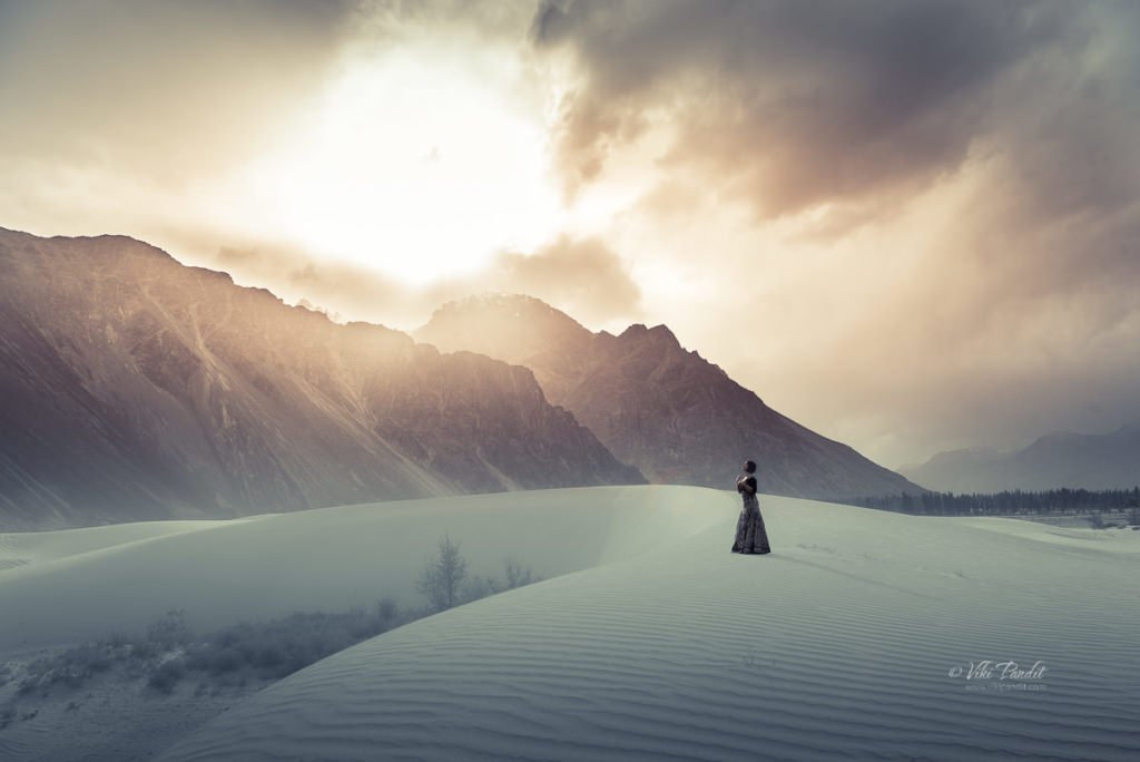
Dunes of Nubra

Nestled amidst the majestic peaks of the Himalayas in the northernmost region of India, Nubra Valley is a surreal and enchanting destination that captivates a photographer’s heart. Situated at an altitude of around 10,000 feet above sea level, this high-altitude cold desert boasts a landscape characterized by sweeping sand dunes and rugged terrains.

The valley lies between the two well-known Himalayan mountain ranges of the Karakoram (on the North), and the Ladakh (on the South). From Leh, we drove to Nubra across the Khardungla pass. The drive to the valley, spans around five hours, through one of the the world’s highest motorable roads.

Each twist and turn on the drive offers a new perspective of the desert’s beauty. At some points, the roads are treacherous but the awe-inspiring mountain vistas makes one ignore all the bumps on the road.

After the captivating drive through the mountains, we stopped at a dhaba near Khardung. The meal comprised steamed rice and dal along with some vegetables. Eateries are separated by long intervals so make sure you carry some biscuits or other beverages for the trip.

Just before we entered the valley, we came across some locals offering services for Quad biking. I have not driven one yet but a ride through this vast expanse of the desert must be an exhilarating adventure for those interested. The powerful hum of the quad bike engine echoed against the sandy dunes as we drove past them. The freedom to traverse the open desert, with its golden hues stretching as far as the eye can see, is an unmatched experience.

Diskit Monastery

Just before reaching Hunder, we took a small detour to Diskit Monastery, also known as Deskit Gompa. The monastery stands as the oldest and largest Buddhist monastery in the enchanting Nubra Valley. Constructed in the 14th century by Changzem Tserab Zangpo, a devoted disciple of Tsong Khapa, the founder of the Gelugpa (Yellow Hat) sect of Tibetan Buddhism, it serves as a sub-gompa to the Thikse gompa in Leh. Poised on the precipitous cliffs, the monastery exemplifies the Tibetan box structure, crafted from a blend of stones, mud, and wood.

Within its sacred walls, ancient scriptures, sculptures, murals, frescoes, brocades, and thangkas are housed, each narrating a tale of spiritual heritage. The Mahakali temple, statues of Tibetan deities, the Sakyamuni Temple, and the prayer hall add an air of mystery to this sacred sanctuary.

Near the historic Diskit monastery, the renowned 106-foot-tall statue of Maitreya Buddha stands as an iconic presence. Inaugurated by His Holiness the Dalai Lama in 2010, the enigmatic statue serves as a profound symbol of global peace and a vision for a future free from warfare.

Positioned on a hilltop, it offers a mesmerizing 360-degree panoramic vista. The bird’s-eye view unveils the picturesque Diskit Village in Nubra Valley, leaving us in awe of the vastness and tranquility of nature.

A quick 20-minute drive from Diskit Village transports us to the extraordinary realm of Hunder. Situated about 10 kilometers from Diskit, Hunder unveils a fascinating juxtaposition of snow-capped mountains and sand dunes, making it the sole location in India where these contrasting landscapes coexist in a single frame.

We were staying at the Hunder Sarai. The camps are surrounded by barren cold mountains and just about a 10-minute drive to the dunes. Hunder does have a mobile tower, but the network connectivity is not good. In between the gardens, outside slows a stream of crystal clear water. After a quick change of clothes, we directly drove to the dunes.

On the way, we noticed some camels making their way towards the dunes as well. The double-humped Bactrian camels are a distinctive feature of Hunder. It is said that Hunder used to be a crucial stop on the ancient Old Silk Route and these camels were brought in from Central Asia. In fact, it was still a trade route between Yarkand (present-day Xinjiang, China) and Leh, the capital of Ladakh, till the closing of borders in 1949 CE.

A camel safari atop these furry, double-humped creatures, navigating the silver or white sand dunes, becomes a once-in-a-lifetime adventure. The panoramic view of colossal mountains against the intensely blue sky, alongside the pristine white dunes will be etched in your memory for life.

The desert’s extremes are felt with the scorching sun in open areas and a sudden chill in the shade, necessitating layered clothing, sunscreen, and of course sunglasses. I would recommend staying in tents as the nights though chilly, promise a spellbinding display of the starry sky over the village.

Despite its arid and challenging conditions, Nubra’s cold desert boasts a unique ecosystem adapted to the harsh environment. Nomadic communities, such as the Changpas, have traditionally herded livestock in this challenging landscape, showcasing the resilience of life in the cold desert.

The Nubra region is the northernmost of Ladakh and in fact of all of India. It is fed by two main rivers: the Shyok and the Siachen. Both originate from the Siachen glacier but are on either side of the western Karakoram Range.

The climate of the regions is extremely harsh with scanty rainfall along with less moisture contained in the air. The minimum temperature in winter drops to -30 °C, and the maximum temperature is around 25 °C in the summer. In Nubra valley, the source and supply of water from glaciers is the only option for irrigation purposes, and portable water which is flowing through the two main rivers such as Nubraand Shayok, originates from the Siachen glacier and Remo glacier, respectively.

As the day passes, the winds pick up and create a kind of sandstorm. The sand dunes of Nubra are situated at the confluence of the Nubra and Shyok Rivers, creating a surreal desert landscape surrounded by majestic mountains. The dunes, predominantly composed of fine-grained sand, are sculpted by the relentless forces of wind, carrying sand particles from the riverbeds and depositing them in the valley. This continuous process shapes the dunes into undulating patterns, creating an ever-changing canvas of nature’s artistry.

The evening was cloudy and the sand kept blowing into our eyes. The weather is not friendly here and it gets pretty cold once the Sun hides behind the clouds. With every hour, the strong breeze keeps blowing the fine sand, reshaping them into new shapes. Even though the sand was harsh, we did get some wonderful photos. The wind whistles past, carrying the essence of the arid wilderness, while the rhythmic dance of the dunes creates a visually captivating spectacle.

Time passed quickly and soon the Sun was setting behind the mountains. The Nubra region is well known for its role as a gateway between the Indian subcontinent and Central Asia in modern times.

The voyage to Diskit Village in Nubra Valley is an exceptional experience, both literally and metaphorically placing me on top of the world. Traversing through Khardung La, the pass that once held the distinction of being the world’s highest motorable road at 18,380 feet, I found myself amidst unparalleled beauty. Presently, Umling La claims the title as the world’s highest motorable road, reaching an elevation of 19,300 feet in Ladakh.

The clear and unpolluted skies of Nubra Valley offer breathtaking views of the night sky, making it an ideal location for stargazing amid the tranquil desert setting.

Ladakh stands as one of the most stunning yet environmentally delicate regions in our country, emphasizing the need for tourists to be mindful of their impact on the area. The Ladakh region boasts breathtaking beauty with its cold desert landscape, yet it remains sparsely populated. It welcomes tourists from April to September, primarily during the summer months. While the improved infrastructure has brought economic benefits to the locals, the surge in tourism has raised concerns among environmental experts. Many argue that unregulated tourism poses a potential threat to the ecologically sensitive region.

Next, we move on to Pangong Tso, renowned for its stunning natural beauty. Surrounded by towering snow-capped peaks, the lake’s crystal-clear blue waters create a mesmerizing and picturesque landscape that is said to be a photographer’s dream. Thank you for taking the time to read my blog! Your interest and engagement mean the world to me. If you have any thoughts, comments, or questions, I’d love to hear from you.

Tourist Information

An Inner Line Permit (ILP), which can be acquired at the District Commissioner’s office in Leh, is required for tourists, Indians, and foreigners alike. People are required to check in en route and must provide photocopies of the permits to be deposited at each checkpoint.

Altitude sickness is a serious health concern for people not previously used to high altitudes. Prophylactic altitude-sickness medication such as Diamox may be necessary for some as there are no emergency medical facilities to treat altitude sickness along the route.

The road is closed from approximately October to May due to snow and is often subject to long delays due to traffic congestion on narrow one-lane sections, washouts, landslides and road accidents.