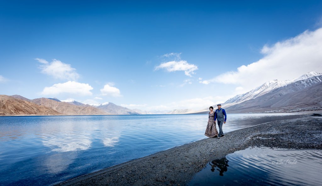
Blue waters of Pangong Tso

The journey to Pangong Tso starts from Nubra Valley. We had a lovely day among the sand dunes of Nubra.

Drive from Nubra to Pangong Lake

The drive from Nubra to Pangong takes you through a wide varied landscape. The Shyok river stays with us for most part of the ride.

Once the river leaves us and goes on its own way near Durbuk, the road too becomes quite bad. In fact, at certain points, it was almost impossible to make out where the road was.

After a few hours we reached the Changthang Cold Desert Wildlife Sanctuary. This is the only place where you can see some vegetation. I caought some Pashmina goats grazing happily in the meadows

This little guy almost head butted me… he was probably taking care of the herd.

You can also find some horses lazying around in the cool breeze.

The roads near the santuary are well maintaned. The landscape also changes to a more pleasant view.

And then we see the first views of the Pangong Lake.

Pangong Viewpoint

We were staying in Spangmik village, but we first hit the popular viewing point, so we stopped there for a few minutes. It was around 2 pm and it was perfect to capture the beautiful lake in the brilliant light.

We moved around the edge of the huge lake taking shots of the crystal clear waters of the lake.

You can find Yaks available for rides if you want one.

You can see the changing colors of the water in the lake. It is greening towards the edges and more blue as you move your eyes towards the center.

After capturing some really amazing photos of the lake we moved on towards Spangmik village.

On the way we took more pictures of the mesmerizing lake.

Just before reaching the village, we passed an area with wide open space in front of the lake. Tsering, our chauffeur informed us that he will be taking us there in the evening, which is another wonderful place to enjoy the breathtaking scenery.

By 3 pm we had reached our lodgings at Spangmik.

It was May and still the mountains tops were covered in Snow.

After refreshing ourselves, we were ready for the second round. As promised Tsering took us to this lovely viewpoint from where you could capture the lake in its full beauty.

Mani modeled for me as I captured some amazing potraits. It was only 4 pm but the breeze had picked up and it was lethally cold. I was somewhat safe in my blazer, but Mani was having a tough time in the cold.

I quickly captured a shot of us before the cold really started to hurt.

With the Sun behind the mountains, the lake had turned into a deep blue color.

Shivering from cold, we hurried back to our tents. The tents lie at the edge of the banks. After a warm tea, we walked around in the evening.

The strong chilly breeze drove us inside the comfort of the tent. The night was extremely cold and even though I want to capture the stars over Pangong Tso, my body was too cold to come out.

In hind-sight, I should have stayed back for a day, but with a tight schedule, we had to move back to Leh the next day.

Next Morning…

The light is extremely bright in the mornings, so carry your eye shades.

We passed the lovey viewpoint we stopped at the day before for a few minute, but the light was too strong to capture good photos.

By 10 pm we are back on the road to Leh.

Dunes of Nubra

Nestled amidst the majestic peaks of the Himalayas in the northernmost region of India, Nubra Valley is a surreal and enchanting destination that captivates a photographer’s heart. Situated at an altitude of around 10,000 feet above sea level, this high-altitude cold desert boasts a landscape characterized by sweeping sand dunes and rugged terrains.

The valley lies between the two well-known Himalayan mountain ranges of the Karakoram (on the North), and the Ladakh (on the South). From Leh, we drove to Nubra across the Khardungla pass. The drive to the valley, spans around five hours, through one of the the world’s highest motorable roads.

Each twist and turn on the drive offers a new perspective of the desert’s beauty. At some points, the roads are treacherous but the awe-inspiring mountain vistas makes one ignore all the bumps on the road.

After the captivating drive through the mountains, we stopped at a dhaba near Khardung. The meal comprised steamed rice and dal along with some vegetables. Eateries are separated by long intervals so make sure you carry some biscuits or other beverages for the trip.

Just before we entered the valley, we came across some locals offering services for Quad biking. I have not driven one yet but a ride through this vast expanse of the desert must be an exhilarating adventure for those interested. The powerful hum of the quad bike engine echoed against the sandy dunes as we drove past them. The freedom to traverse the open desert, with its golden hues stretching as far as the eye can see, is an unmatched experience.

Diskit Monastery

Just before reaching Hunder, we took a small detour to Diskit Monastery, also known as Deskit Gompa. The monastery stands as the oldest and largest Buddhist monastery in the enchanting Nubra Valley. Constructed in the 14th century by Changzem Tserab Zangpo, a devoted disciple of Tsong Khapa, the founder of the Gelugpa (Yellow Hat) sect of Tibetan Buddhism, it serves as a sub-gompa to the Thikse gompa in Leh. Poised on the precipitous cliffs, the monastery exemplifies the Tibetan box structure, crafted from a blend of stones, mud, and wood.

Within its sacred walls, ancient scriptures, sculptures, murals, frescoes, brocades, and thangkas are housed, each narrating a tale of spiritual heritage. The Mahakali temple, statues of Tibetan deities, the Sakyamuni Temple, and the prayer hall add an air of mystery to this sacred sanctuary.

Near the historic Diskit monastery, the renowned 106-foot-tall statue of Maitreya Buddha stands as an iconic presence. Inaugurated by His Holiness the Dalai Lama in 2010, the enigmatic statue serves as a profound symbol of global peace and a vision for a future free from warfare.

Positioned on a hilltop, it offers a mesmerizing 360-degree panoramic vista. The bird’s-eye view unveils the picturesque Diskit Village in Nubra Valley, leaving us in awe of the vastness and tranquility of nature.

A quick 20-minute drive from Diskit Village transports us to the extraordinary realm of Hunder. Situated about 10 kilometers from Diskit, Hunder unveils a fascinating juxtaposition of snow-capped mountains and sand dunes, making it the sole location in India where these contrasting landscapes coexist in a single frame.

We were staying at the Hunder Sarai. The camps are surrounded by barren cold mountains and just about a 10-minute drive to the dunes. Hunder does have a mobile tower, but the network connectivity is not good. In between the gardens, outside slows a stream of crystal clear water. After a quick change of clothes, we directly drove to the dunes.

On the way, we noticed some camels making their way towards the dunes as well. The double-humped Bactrian camels are a distinctive feature of Hunder. It is said that Hunder used to be a crucial stop on the ancient Old Silk Route and these camels were brought in from Central Asia. In fact, it was still a trade route between Yarkand (present-day Xinjiang, China) and Leh, the capital of Ladakh, till the closing of borders in 1949 CE.

A camel safari atop these furry, double-humped creatures, navigating the silver or white sand dunes, becomes a once-in-a-lifetime adventure. The panoramic view of colossal mountains against the intensely blue sky, alongside the pristine white dunes will be etched in your memory for life.

The desert’s extremes are felt with the scorching sun in open areas and a sudden chill in the shade, necessitating layered clothing, sunscreen, and of course sunglasses. I would recommend staying in tents as the nights though chilly, promise a spellbinding display of the starry sky over the village.

Despite its arid and challenging conditions, Nubra’s cold desert boasts a unique ecosystem adapted to the harsh environment. Nomadic communities, such as the Changpas, have traditionally herded livestock in this challenging landscape, showcasing the resilience of life in the cold desert.

The Nubra region is the northernmost of Ladakh and in fact of all of India. It is fed by two main rivers: the Shyok and the Siachen. Both originate from the Siachen glacier but are on either side of the western Karakoram Range.

The climate of the regions is extremely harsh with scanty rainfall along with less moisture contained in the air. The minimum temperature in winter drops to -30 °C, and the maximum temperature is around 25 °C in the summer. In Nubra valley, the source and supply of water from glaciers is the only option for irrigation purposes, and portable water which is flowing through the two main rivers such as Nubraand Shayok, originates from the Siachen glacier and Remo glacier, respectively.

As the day passes, the winds pick up and create a kind of sandstorm. The sand dunes of Nubra are situated at the confluence of the Nubra and Shyok Rivers, creating a surreal desert landscape surrounded by majestic mountains. The dunes, predominantly composed of fine-grained sand, are sculpted by the relentless forces of wind, carrying sand particles from the riverbeds and depositing them in the valley. This continuous process shapes the dunes into undulating patterns, creating an ever-changing canvas of nature’s artistry.

The evening was cloudy and the sand kept blowing into our eyes. The weather is not friendly here and it gets pretty cold once the Sun hides behind the clouds. With every hour, the strong breeze keeps blowing the fine sand, reshaping them into new shapes. Even though the sand was harsh, we did get some wonderful photos. The wind whistles past, carrying the essence of the arid wilderness, while the rhythmic dance of the dunes creates a visually captivating spectacle.

Time passed quickly and soon the Sun was setting behind the mountains. The Nubra region is well known for its role as a gateway between the Indian subcontinent and Central Asia in modern times.

The voyage to Diskit Village in Nubra Valley is an exceptional experience, both literally and metaphorically placing me on top of the world. Traversing through Khardung La, the pass that once held the distinction of being the world’s highest motorable road at 18,380 feet, I found myself amidst unparalleled beauty. Presently, Umling La claims the title as the world’s highest motorable road, reaching an elevation of 19,300 feet in Ladakh.

The clear and unpolluted skies of Nubra Valley offer breathtaking views of the night sky, making it an ideal location for stargazing amid the tranquil desert setting.

Ladakh stands as one of the most stunning yet environmentally delicate regions in our country, emphasizing the need for tourists to be mindful of their impact on the area. The Ladakh region boasts breathtaking beauty with its cold desert landscape, yet it remains sparsely populated. It welcomes tourists from April to September, primarily during the summer months. While the improved infrastructure has brought economic benefits to the locals, the surge in tourism has raised concerns among environmental experts. Many argue that unregulated tourism poses a potential threat to the ecologically sensitive region.

Next, we move on to Pangong Tso, renowned for its stunning natural beauty. Surrounded by towering snow-capped peaks, the lake’s crystal-clear blue waters create a mesmerizing and picturesque landscape that is said to be a photographer’s dream. Thank you for taking the time to read my blog! Your interest and engagement mean the world to me. If you have any thoughts, comments, or questions, I’d love to hear from you.

Tourist Information

An Inner Line Permit (ILP), which can be acquired at the District Commissioner’s office in Leh, is required for tourists, Indians, and foreigners alike. People are required to check in en route and must provide photocopies of the permits to be deposited at each checkpoint.

Altitude sickness is a serious health concern for people not previously used to high altitudes. Prophylactic altitude-sickness medication such as Diamox may be necessary for some as there are no emergency medical facilities to treat altitude sickness along the route.

The road is closed from approximately October to May due to snow and is often subject to long delays due to traffic congestion on narrow one-lane sections, washouts, landslides and road accidents.

Road to Khardungla Pass

Ladakh is the highest altitude plateau in India. It is situated in the state of Jammu and Kashmir, bound by two of the world’s highest mountain ranges, the Karakoram in the north and the Himalayas in the south.

Khardung La is a mountain pass in Ladakh that serves as the gateway to the Shyok and Nubra valleys from the city of Leh. Though we write it as Khardung La, the local pronunciation is more like “Khardong La” or “Khardzong La.” The word La means pass while Kharzong means castle. I am not sure how the combination of these words were used to name this mountain pass.

Ride to Khardungla Pass

We were staying at the Shaolin Guest House in Leh. Leh is the largest settlement in Ladakh. It is a town of modest bazaars and winding streets, hemmed by rugged hills. A few of the main attractions are the Shanti Stupa, Namgyal Tsemo Gompa and Leh Palace. These places lie quite close to each other and can be visited in a single day.

We were leaving for Nubra Valley. Tsering, who was our designated chauffeur for the trip was at the gate exactly on time to pick us up for the long ride to Nubra Valley via Khardung La. The 150-km journey from Leh to the Nubra Valley includes some of the most diverse and exhilarating topography in the world, and its high point (both literally and metaphorically) is the Khardung La.

As we drove into the mountains, the air began to feel chilly. Due to the high altitude of Ladakh, the climate is very cold and the air is very thin, which in turn makes the heat of the sun extremely harsh. I don’t think I ever saw Tsering without a thick layer of sunscreen on his cheeks.

The geographical location of Ladakh ranges from 2,750 m high at Kargil to 7,672 m high at Saser Kangri in the Karakoram Range. The average height of the plateau is around 3,000m, and the numerous motor-able high altitude passes, such as Khardung La, Changa La, and Thaglang La allow for the region to be connected albeit during the summer months.

The motorway was built in 1976. It was opened to public vehicles much later in 1988. But the history of this road is much more ancient. Traders of the Silk Route, which developed in the pre-Christian era used the pass to travel between Leh and Kashgar in Xinjiang province of China. The 2000 meter climb to the pass provides thrilling panoramic views of the Zanskar Range beyond the Indus Valley and towards the Karakoram.

Khardung La is about 40 km by road from Leh. There are two bases on either side of Khardung La – North Pullu and South Pullu. The first 24 km, as far as the South Pullu check point, are paved. From there to the North Pullu checkpoint about 15 km beyond the pass the roadway is primarily loose rock and dirt.

Khardung La Viewpoint

The journey unfolded along perilous yet picturesque routes, with glacial snow flanking the roads and majestic, snow-covered mountains reaching towards the enchanting blue sky. The sheer ecstasy I felt during the drive is a sentiment shared by travelers globally who dream of navigating Ladakh’s roads by car or motorcycle. Gratitude extends to the Border Roads Organisation (BRO) and the Indian Army for their unwavering dedication to maintaining these roads, turning the dreams of many, including ours, into reality.

The elevation of Khardung La is claimed to be 5,359 m (17,582 ft). Earlier it was miscalculated to be around 18380 ft, which has now been corrected using measures from various other GPS surveys including SRTM data and ASTER GDEM data.

Maintained by the Border Roads Organization (BRO), the road is open to tourists all year round, but even now in the summer months, we could see icicles hanging along the sides from the rock faces. We stayed at the viewpoint for about 20 minutes and towards the end of the stay I could feel the dizzyness coming over me. We left soon afterwards. In fact a signboard nearby discourages tourists from staying beyond half an hour at this place.

A few minutes after the viewpoint, the roadsides were completely covered in snow. It was biting cold outside. In olden times the Ladhakis used to refer to India as Gyagar (gar or kar: white, ‘where people wear white clothes’). Here ‘white’ signifies the difficulties of living. For them life appeared more grim on the Tibetan plateau while they had always heard of warm and pleasant life in the Indian plains. Experiencing this level of snow in summer I can totally understand their hardship living in these cold mountains.

Towards Nubra Valley

From North Pullu into the Nubra Valley, the road was very well maintained.

As we descended we witnessed the first views of the Shyok river emerging from the eastern side of the Karakoram and flowing north– south before it takes a westerly course to join the Nubra river. In contrasting terms Nubra Valley means a valley of flowers while the Shyok river that flows into it means the ‘River of death’

An hour’s drive downhill from Khardung La leads to the first stop in Nubra called Khardung, a small village in a sandy flatland. We took our lunch at the village. Nearby some wild asses were busy munching on the rare green grass. This was our first view of any greens since leaving Leh.

Soon after, at Tirit, the road bifurcates: one takes you to the valley of the Shyok river which has the towns of Diskit and Hunder, with a magnificent high-altitude desert between them; and the other to the green valley of the Nubra river, towards Sumur and Panamik.

As we got closer to Hunder, the weather changed drastically and we were surrounded by sand from the cold desert. The skies had turned ominously gray, but we moved on excited and looking forward to our next stop: Sand dunes of Nubra.

Tourist Information

An Inner Line Permit (ILP), which can be acquired at the District Commissioner’s office in Leh, is required for tourists, Indians, and foreigners alike. People are required to check in en route and must provide photocopies of the permits to be deposited at each checkpoint.

Altitude sickness is a serious health concern for people not previously used to high altitudes. Prophylactic altitude-sickness medication such as Diamox may be necessary for some as there are no emergency medical facilities to treat altitude sickness along the route.

The road is closed from approximately October to May due to snow and is often subject to long delays due to traffic congestion on narrow one-lane sections, washouts, landslides and road accidents.

Finding peace at Shanti Stupa

The unique beauty of Ladakh lures visitors from all across the globe. The union territory is geographically located in the westernmost extension of the Tibet plateau. Its name ‘Ladakh’ literally means “the land of passes.” The capital city, Leh, hosts the only airport. During the winter months, Ladakh is completely cut off from the rest of the country.

As summer approaches, tourists queue up in hoards to lose themselves in the serenity, tranquility, and spirituality of this desolate world. Also known as “Little Tibet” the city is known for its colorful culture and rich traditions of Mahayana Buddhism that still flourishes in the purest form in this region.

Shanti Stupa is one of several must-visit destinations in Leh. Surrounded by lofty mountains it has a special place in the cultural history of Ladakh. This white-domed Stupa on a hilltop in Leh was conceived by Japanese Buddhist Bhikshu, Gyomyo Nakamura as part of the Peace Pagoda mission.

Walk to Shanti Stupa

We had spent the earlier part of the day exploring Namgyal Tsemo Gompa and Leh Palace. All the walking had left us tired. We took a brief rest at the Shaolin Guest House, and then towards early evening, left for the peace pagoda.

Shaolin Guest House lies a couple of kilometers east of the Shanti Stupa. We walked down Sankar Road and then onto the Shanti Stupa Road. The walk is not difficult but it is not recommended for tourists coming from the plains as they might experience breathlessness because of the high altitude.

It is advisable that you take the first day off and just relax. It will help your body to acclimatise to the thin air in Leh.

Midway through the walk we were greeted by the picturesque Poplar trees. With its towering height, the Poplars stand distinctly in the landscape of Leh. These Poplar trees are said to mature very quickly growing up to 8 feet in the very first year. In the barren desert with almost no vegetation, the brilliant green trees are a sight for sore eyes. On the way, we passed by many small single-floor houses, some made of bricks and some of mud. The boundary of these dwellings are marked with medium-height ash-colored brick walls.

As we reach the outskirts of the city, the road starts to go uphill and the houses gradually disappear. The evening was breezy and we didn’t feel any discomfort hiking up the hill.

The Shanti Stupa road would be the easiest way to reach the Stupa. The motorable road leads right up to the gates of the Stupa. One can also reach here by climbing near-500 steps from the opposite side of the hill but in my opinion, it is not a recommended route for the unfit.

It was 7 pm by the time we reached the entrance of the Stupa. The Sun had hid behind the mountains but the light was still great. Situated on the hilltop at Changspa at a height of 4267 meters, the Stupa provides wonderful panoramic views of the surrounding mountains.

Buddhism in Ladakh

It is said Buddhism penetrated Ladakh during the time of Emperor Ashoka in around 204 BC. But even before the reign of Ashoka, the Arhat Majhantika blessed these lands with his visit and prophesied this region becoming a stronghold for the Buddhist religion in the Himalayas. Ladakh was in those times known as Mar-yul (Red Land).

It cannot be denied however that it was during Ashoka’s reign that Buddhism spread rapidly and took a stronghold in this part of the world. The indigenous community which were mostly nomadic and lived off meat at that time, gradually absorbed the concept of vegetarianism that is still followed today.

The reign of Ashoka also introduced the religion in Japan. The teachings of Buddha aroused new consciousness in the people of Japan and thus rose Todaiji, the greatest of the Buddhist temples in the world. And this brings us to the Shanti Stupa which stands for Leh as a mark of the friendship between two countries connected by a religion of peace.

History of Shanti Stupa

The idea of Shanti Stupa has its roots in a vision conceived many years before by Nichidatsu Fujii. Nichidatsu Fujii [1885-1985] more commonly known as Guruji, was the founder of the Buddhist religious order, Nipponzan Myohoji, which is dedicated to working for world peace through Peace Walks and the construction of Peace Pagodas across the world.

Around 1842, repeated invasions of Ladakh by the Kashmiri rulers shook Buddhism at its roots. Led by Maharaj Gulab Singh, the Dogra rulers undermined the aristocracy of Ladakh and brought about what is regarded as the darkest hour in the history of Buddhism in Ladakh. Alien to the local culture, they did considerable damage to the gompas and the stupas in the region. As a part of his mission to resurrect Buddhism back in Ladakh Bhikshu Gyomyo Nakamura conceived the idea of building the Shanti Stupa in Leh.

Shanti Stupa in Leh

Construction of the Shanti Stupa began in April 1983 under the supervision of Bhikshu Gyomyo Nakamura and Kushok Bakula, a lama from Ladakh. The project was built with the help of Ladakhi Buddhists, who offered voluntary labor, and Japanese Buddhists, who consider India as the “sacred” birthplace of the Buddha.

The Shanti Stupa holds the relics of the Buddha at its base, enshrined by the 14th Dalai Lama. The 14th and current Dalai Lama, Tenzin Gyatso inaugurated the Shanti Stupa in August 1991 celebrating 2500 years of Buddhism.

The beautiful Stupa today stands as a symbol of the friendly ties between the people of Japan and India. Since its inauguration, Shanti Stupa has become a popular tourist attraction. The Stupa overlooks the city of Leh, providing panoramic views of the city, the village of Changspa, Namgyal Tsemo in the distance, and the surrounding mountains.

Depictions of Buddha at Shanti Stupa

We waited for the dusk to arrive hoping the tourists would clear by then. Far away we could see the sun set over the lovely city of Leh. Mountains are the crowning glory of the region, as they stand tall, overpowering, and majestic in myriad colors.

The Shanti Stupa features a photograph of the current Dalai Lama with the relics of the Buddha at its base. The Stupa is built as a two-level structure. The first level features the central relief of Dharmachakra with deer on each side.

As we move up the stairs we face the central structure that features an image of Lord Buddha in golden color sitting on a platform turning the Dharmchakra wheel.

On the same level, as you walk around the circular path, we can find three other images depicting the birth of Buddha, the defeating of devils in meditation and the death of Buddha along with many small images of meditating Buddha, embossed in vibrant colors.

Both levels feature a series of smaller meditating Buddha reliefs along the walls of the central structure.

And the most important of all the Nirvana tablet that features the Buddha lying on his right side with his head supported by a pillow or his propped-up hand and elbow. Though this representation of the Buddha can indicate sleeping or resting, it is most commonly a representation of the final moments at the end of the life of the Buddha.

Parinirvana is a Mahayana Buddhist festival that marks the death of the Buddha.

Called maha parinirvana, this transitional state occurs only to those who have reached enlightenment, or nirvana, during their lifetime. Those who achieve nirvana are released from samsara, the cycle of rebirth, and karma. Instead, when they die, they reach nirvana-after-death or the eternal Self. It is also known as Nirvana Day and is celebrated on February 15th. Buddhists celebrate the death of the Buddha because they believe that having attained Enlightenment, he achieved freedom from physical existence and its sufferings.

Evening at Shanti Stupa

Dusk was upon us and the lights along the Stupa were gradually lighting up one by one. The crowd had dispersed by the evening, allowing for a more tranquil experience in this remote yet captivating locale. The white-colored domed-shaped structure looked extremely beautiful during the night when it was illuminated.

It was dark soon and the sky was lit with a billion stars. The moon was nowhere to be seen even though the Amavasya (New Moon) had passed a couple of days back. On the way downhill a cafe was still open where we gathered some warmth with a hot tea and a bag of chips. It was late and we were the only guests at the dimly lit cafe.

The walk downhill was relatively easy. Although by that time it was pitch dark. The area is devoid of any street lights. Holding hands and armed with a torch we slowly made our way back to the Hotel. It was a walk that I will always remember.

In 1974, when Ladakh was first opened for tourism, around 400 to 500 tourists used to visit a year, and with time the numbers rose every year. Today in 2018, around 6 to 7 Lakh tourists visit Ladakh every year. Tourism can be a double-edged sword. It can bring economic benefits but can also harm the environment and local communities. As a tourist, we must try to respect the local culture and not be disruptive to the environment.

Our upcoming schedule takes us to Nubra valley where if I am fortunate, I look forward to capturing some nice dunes. Your interest and interaction are incredibly valuable to me. Feel free to share your thoughts, comments, or questions – I would love to hear from you.

Visitor Information

Timings

The Stupa is open for tourists between 5:00 a.m. and 9:00 p.m

How to reach Shanti Stupa?

The Stupa can be reached by a drivable road or on foot using a series of 500 steep steps to the hilltop.

What is the most delicious food in Leh?

The most popular ladakhi foods are Thukpa (noodle soup) and Tsingmo (steamed buns).
When in Ladakh also enjoy the buckthorn juice which is indigenous to the union territory

What are the best restaurants in Leh?

Tibetan Kitchen and Gesmo are two of my favorite restaurants in Leh. If you are up for a coffee, you must try Lehvenda in the main market area. It is amazing.