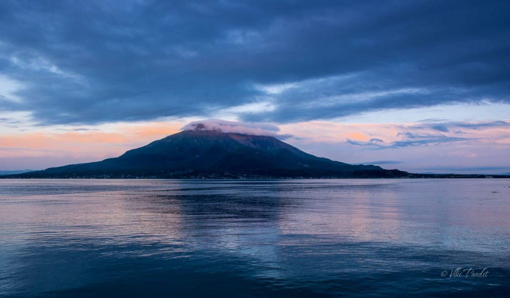
The sleeping SakuraJima

Today we took a bus to the Kagoshima pier to witness the mighty Sakurajima. Sakurajima is one of Japan’s most active volcanoes and the symbol of Kagoshima. Approximately 10 billion tons of lava has flowed out over the years. Its frequent lava flows have resulted in the former island to be connected with the Osumi Peninsula.

Lovers Sanctuary on Mount Moiwa

We woke up to a beautiful sunny day. The grey clouds from the day before had cleared up. It was the last day of our Hokkaido trip. We lazed around at the hotel discussing the amazing places we had been to on this trip. It wasn’t until noon that we left the hotel for Mount Moiwa.

How to reach Mount Moiwa

Mount Moiwa or Moiwa-yama (藻岩山) is one of several small, forested mountains southwest of Sapporo. The mountain is known for the spectacular view of the city from an observation deck at its summit. From here one can view a spectacular panorama of the streets of Sapporo, Ishikari Bay and the Shokanbetsu Peak.

We were staying at a hotel was near Nakajima-koen Park. From there, we took the subway to Odori Station. From Odori, the streetcar took us towards the Iriguchi Ropeway stop. The streetcar costs a fixed ¥170, wherever you are going. It keeps running in a loop and is very frequent. If you are catching the streetcar from Odori, note that you should catch the counter-clockwise loop. The clock-wise streetcar takes a longer time.

During our visit they were giving a discount coupon for the ropeway. One can obtain it at the tourist information counter, or pick it up in the streetcar itself, like we did.

From the Iriguchi Ropeway tram stop, there is a shuttle bus that leaves every 15 minutes. The ride on the shuttle bus is free. The bus took us right up to the entrance of the ropeway. It appears no one goes to this place in the daytime. We were the only couple on the shuttle.

Mount Moiwa Ropeway

We bought our tickets and waited at the lounge while the Gondola came down to pick us up. The tickets are priced at ¥1500 per person. The Mt. Moiwa Ropeway climbs from the base of the mountain to about three-quarters up the mountain to a transfer station. The Ropeway opened way back in 1958. It is around 1.2-kilometer long ride. Renovated in 2012, one ropeway cabin can hold about 60 people.

I was happy to see some other visitors at the base station. The gondola arrived soon. Its cabin has large glass sides and it was quite thrilling to see the wild forest and the city as we went up the snow covered mountain.

Sapporo Peace Pagoda

Halfway up Mount Moiwa, I noticed a Stupa. The bulbous white stupa is more of a peace memorial, like the ones we visited in Hiroshima and in Leh. The pagoda was built in 1959 by the Nipponzan-Myōhōji monks to commemorate peace after World War II, and supposedly contains some of the ashes of the Buddha that were presented to the Emperor of Japan by Prime Minister Nehru in 1954.

After a thrilling ride we found ourselves at the first base, also known as the Moiwa Chufuku Station. If you want to get some souvenirs, this is the place to get one. You can also get a lovely view of Sapporo city from here.

After a small wait at the transfer station, we had to change to the green colored “Moorisu Car” – a mini cable car, that took us rest of the way up to the Moiwa Sancho Station at the summit.

Both the transportation’s are unique and fun. The mini cable car is called Moorisu, named after the cute mascot of the mountain.

Mount Moiwa in Winter

Mt. Moiwa, reaches an altitude of 531 meters. The original name of the mountain is “Inkarushibe” in the Ainu language and it was considered sacred by the Ainu. The mountain is home to some unique species such as the Ezo spruce and Moiwa linden trees. The mountain is a popular trekking destination during the summer weekends.

We reached the summit quite a bit before sunset. There is a Buddhist temple at the summit, but it was closed due to the heavy snow surrounding it.

Lovers Sanctuary on Mt. Moiwa

The summit was much colder. The summit deck was empty with maybe 4-5 other visitors apart from us. I thought there would be more. It was refreshing breathing in the fresh air of the mountain. On the deck there is a unique structure known as Lovers Sanctuary. It features a bell at the center. Beside it you can find some padlocks hanging by the sides on the handrails.

It is said that if the lovers attach the love padlock (sold at the shop in midway stop) to the handrails around the sanctuary, and ring the bell together, happiness will follow them into their future.

Lovers Sanctuary on the observation deck at the summit of Mt. Moiwa where couples pledge their love for each other by attaching a padlock and ringing the bell.

It’s a wonderful sight from the summit. On one side I could see the sprawling city of Sapporo and on the other side an amazing the panoramic views of Ishikari Plain and far mountains.

Surrounding mountains of Sapporo

The city of Sapporo is surrounded by many mountains. Towards the southeast, one can see the Yakiyama mountain in a distance. Skiing is a favourite past-time of locals in winter. Not surprising for a city where snow covers the ground 133 days a year. For the skiing enthusiasts, the Mount Moiwa Ski Resort lies on the mountain’s southeastern slope.

Note: it is approached from a different direction than the Mount Moiwa Ropeway.

I walked around in a circle around the observation deck, clicking photos of the beautiful scenery surrounding the mountain-top. Below you can see the Mount Kannoniwa on the eastern side of Sapporo.

As I came around the full circle. the lights had started to glitter over the city of Sapporo. Until the end of the Edo Period (1603–1868), Sapporo used to be a trading post between the Japanese mainland and the local Ainu population. There are various theories on the origin of the word “Sapporo.” The leading theory is that it derives from the Ainu (indigenous people of Japan) words “Sap (Dry) – Poro (Wide).”

The ski slopes on the far south at Fu’s Snow Area were also lit up. Fu’s is a small ski resort in the Fujino district with a range of trails, camps & lessons, a simple restaurant & lifts to the peak. During certain times of the winter, night skiing is also allowed on these slopes.

Gradually the sun set behind the mountains and the city started to come alive, twinkling like countless diamonds floating on a dark sea. On the other side the ski slopes near Mount Yaki were lit up like a flash-fire.

Occasionally flying flurries would start to hit our unprotected faces. The temperature was beginning to drop fast and we were freezing. Mani got us a cup of hot coffee from the vending machine inside the deck and it felt like I held heaven between my palms.

Mt. Moiwa is one of the Hokkaido’s top three night views, along with Mt. Hakodate and Mt. Tengu. We didn’t have time for Mt. Tengu in Otaru, the day before, so it was really nice to catch this one on Mt. Moiwa.

As the sun set, large groups of tourists started pouring in. It turned into a huge gathering in a few minutes. With the crowd came a team of video bloggers. They set up their big lights and cameras and blocked everyone. It was quite frustrating as they overran every photogenic spot at the summit.

Sapporo at Night

We stayed back until darkness set in. It was getting more and more crowded with every passing minute. Our heavy jackets were barely holding up to the cold. I took a last shot of the structure and then we headed back to the base.

The ride back downhill on the Gondola, felt like sinking into a sea of twinkling stars.

Sapporo nightscape is one the best night views in Japan. The others being Nagasaki and Kobe.

Being the last night of my Hokkaido trip, I felt deeply reluctant to admit that it was ending so soon. Hokkaido is really beautiful and a place to experience different things in each season. I’ll be back, I hope. Don’t know when, but definitely I will be back!!!

Thanks for reading. Please leave me a comment if you liked the post or follow my story as I visit the lovely temple of Hase-dera in Nara. If you want to check out more night views of Japan, here’s the night-view of Hakodate and night-view of Yokohama.

Mt. Moiwa Ropeway Timings

1st April – 20th November 10:30 am – 10:00 pm
1st December – 31st March 11:00 am – 11:00 pm
New Year’s Eve (December 31st ) 11:00 am – 5:00 pm
New Year’s Day (January 1st ) 5:00 am – 5:00 pm

*Closed from November 21 – 30 for annual maintenance.

Ropeway Fee

Ropeway + Morris Car (Round trip): Adults ¥1,700

Mullayanagiri Trek and Ridge Walk

In my search for peace in the wilderness, I was finally able to force some time out from my work schedule, to go on the trek to Mullayanagiri, the highest peak in Karnataka. I had been planning this trek for some time. In fact, I was all set for this trek in November 2014 but had to cancel it at the last minute. 

Mullayanagiri is located in Chikmagalur, Karnataka, some 280 km away from Bangalore. With the Bhadra Wildlife Sanctuary only 15 km away, the area is rich in vegetation and varied wildlife.

We started from Bangalore late in the night at around 11 p.m. The travel time to Mullayanagiri is around 4 hours. At the base of Mullayanagiri, there is a wildlife outpost. It was early dawn and since the wild animals use the area as a thoroughfare, we had to stop there for over an hour. A handful of us strolled around for the time the bus waited. It was still dark. The guards at the check-post had lit a bonfire, that kept us warm for some time. By 6.00 am, one of the dhaba (eatery) had opened up. I and a couple of the trekkers took an early breakfast of coffee and omelets.

Once the checkpost opened, we drove up the hilly area. The vibrant sun rose from behind the strips of the cloud. That sunrise is still etched in my mind as the sky soon became a painter’s canvas.

By 8 a.m. we were at our homestay. It was a nice, quaint place in the woods. I could hear the sound of water cascading from a tiny spring nearby. From our cottage, I could see a few exotic birds. I went for a walk taking pictures of some birds. I now understand 400 mm is still way short for birding. Maybe I should invest in a teleconverter.

The Trek to Mullayanagiri Peak

After a quick freshening up and breakfast of Idli, we started on our trek to the Mullayanagiri peak.

The bus drove us to the starting point of the trek. We started the ascent at around 10 a.m. A few minutes into the trek one of the guys, Ravi started feeling sick. We waited for some time but eventually, when he did not recover, we had to send him back to the cottage with one of our trek guides. The climb is steep and it was tough with my camera backpack. After climbing for about a couple of hours, we passed a big rock that looked totally like a human face.

After the first hour of climb, the trek becomes relatively easier as we move into the flatter area. At the top, the hills are smooth like meadows. I must say these meadows would look amazing after monsoons when green grass would cover the whole mountain like a carpet.

After hiking through the meadows we reached a cave. I had developed some cramps in my right thigh so I took some rest here. Hydrating oneself is very important on a trek. Not only on the trek, one should hydrate the body a couple of days before the trek.

There was a lot of moss on the walls of the cave. At places where the rocks were visible, one could make out the lines dripping water had created.

From the cave, after a bit of hiking, we finally reached the peak.  Mullayanagiri is part of the Baba Budangiri Hill Ranges and it’s amazing to look at from the peak. I found myself in front of a small temple dedicated to Lord Shiva on top of the hill. The small hillock inside the temple premises is the highest point in Karnataka. The front was still clean, but it was very dirty and smelly overall. We went a few steps down where it was comparatively cleaner and decided to have lunch there. 

After lunch, we got back on the trail. The descent from here was relatively easy. 

The trail becomes a bit steep as we neared the end of our hike. The bus was already waiting for us at the base. We hopped in and on popular demand from the group, headed towards the Dabdabbe waterfalls. I decided to wait for the bus, opting to save my energy for the next day. 

Bonfire

Back at the cottage, we freshened up. Some guys started a game of cards. I went for a walk down the road. it was pitch black just a few meters beyond the cottage. I gathered some courage and kept going for about half a kilometer, eventually, I turned back. I wasn’t able to make a call through my phone. The person who owns/runs the place lent me his phone. He is a nice chap. Talks very humbly. I am going to put his phone number in the FAQs below if anyone needs to contact him for homestay.

Dinner was served at 9 p.m. We had rice and sambar. After dinner, we gathered some wood from the surroundings and started a bonfire starting at around 11 p.m. An alien theory was proposed by one of the trekkers, Altanai, who refuses to acknowledge the theory of Evolution. Our discussion gradually moved on from fantasy to more acceptable on philosophical lines. Eventually, I went to sleep at around 1 am.

I rose up early, washed up, brushed, and went for a walk towards the bushes, where I had spotted some Bulbuls the day before. I waited for a long time patiently eventually a few of them showed up. I was able to get a few shots. 

Mullayanagiri Ridge Walk

I had noticed the Ridge, the day before and it looked overwhelming, so I decided to leave my camera gear behind and concentrate on the climb instead. The ridge walk is not allowed without permission. It’s a steep climb over edgy rocks but not difficult. At certain points, it’s steep and very narrow, but the rocks make it easy to grab and climb. Without the heavy Camera bag, I was feeling a lot free. For the first time, I was leading the trek.

The rocky climb lasted for about an hour, thereafter we hit the meadows again.

After a couple of hours, we could see the BSNL tower. From there we walked along a steep ridge. It was dangerous and thrilling at the same time. Looking on the right towards the abyss made my head go round. So I just kept my head down and eyes on the trail and kept walking.

It would have been safer to use trekking poles in such unsafe areas. One slip can turn out to be fatal. We reached the end of our walk at around noon. We went back to the cottage to have lunch there. On reaching, I went and collected my camera backpack. After a hearty lunch, we headed back to Bangalore.

On the last couple of treks, I felt the focus of the treks had shifted to making noise, jumping around, and taking “flying photos” to obtain likes on social media. It certainly depends on the group of people going on each time. I had really enjoyed the earlier treks I went to last year. Even the group that went to Gokarna was fun. At one point on the trek, some of us had to wait for an hour while others in the group went for a photo session. Not everyone enjoys nature in the same way. I am strongly feeling the need to go solo if I want to truly enjoy nature in peace.

Drive to Bangalore

On the way, we stopped at Chikmagalur for some refreshments. I was feeling dehydrated so I grabbed a Pepsi. From my window seat, I kept watching the fields passing by. I love to stare at nature, it pleases me, like an ecstasy drug. We reached Silk Board stop at 9 pm and in another 30 minutes, I was back at home.

Mullayanagiri is not for the faint-hearted, especially the ridge walk. The trek to the peak is easy to moderate difficulty. I would suggest keeping yourself as light as possible. It was a mistake on my part to take extra lenses on the trek and it weighed heavily on my first day of the ascent. The meadows are excellent especially when you go on the ridge walk, however, note ridge walk is quite a bit on the dangerous side and should not be challenged in the monsoon season. 

Do you have the homestay details?

Eco Holiday Home. The homestay is located on Baba Budangiri Hills. They provide rooms, tents as well as the Cottage where I stayed. The name of the contact person is Aman. His contact number is +91 9481 365 565
Disclaimer: I loved the homestay. The bathrooms were clean and the food was tasty, but I do not accept any responsibility if you use their services.

Are there other any interesting places around Mullayanagiri?

If you are visiting Mullayanagiri, you could also plan a visit to the Bhadra Wildlife Sanctuary. It is only 15 km away

What is the best time for trekking to Mullayanagiri?

Mullayanagiri is pleasant after the monsoons. The lush green meadows are a sight to behold. Although trekking during that time has its disadvantages. Leeches are everywhere. The mist decreases visibility substantially

A Winters Tale II – Pelling

Travel creates memories that last a lifetime. As we left the outskirts of Gangtok, we were both still immersed in thoughts of the lovely time we spent at Changu Lake. On our drive to Pelling, we planned to take a longer route going through Namchi, which is renowned for its beautiful tea gardens. Our driver, Vishnu, a very charming Nepali chap, made our trip to Pelling even more entertaining. All through the next three days, he kept us entertained with his jolly stories. I am going to leave his phone # below in the faqs, so anyone interested can contact him.

Temi Tea Gardens, Ravangla

We reached Temi Tea Gardens at around 11 a.m. The drive to Temi took us through lush green mountain slopes lined with ferns. The beautifully landscaped and manicured tea garden is a visual treat. The fascinating beauty of the tea plantation along-with with 180-degree views of Mt. Kangchenjunga thrilled us to no end. A plaque mentioned that the tea garden is run by the Government of Sikkim and they have done a fascinating job.

The tea from these gardens carries a premium the world over for its exotic flavor. We each had a cup of tea at the only shop around. Mani bought a couple of flavors including one Oolong flavor. Vishnu volunteered to take a few pictures of the picturesque gardens behind us.

In February, the Namchi Garden hosts an annual flower show. The prime attraction of this show is the display of exotic and rare orchids. After a lovely cup of tea, we drove on to our next destination: Samdruptse.

Padmasambhava, Samdruptse

From Temi, we headed towards Samdruptse hill in Namchi. We drove about an hour along winding roads to reach the Samdruptse hill. In the local Bhutia language, Samdruptse translates into “wish-fulfilling hill.” We got down at the gate and started walking towards the top. A few minutes into the path, we could see the gigantic statue of Guru Padmasambhava in a meditation pose. At 120 ft tall, it is said to be the highest statue of Guru Padmasambhava in the world. The statue has a fleet of stairs from where one can climb upward to a platform near the statue’s lap. There is a brick Chorten on the side. In front of the giant statue is another smaller statue of Padmasambhava in a different avatar. We stayed there for some time looking at the masterpiece against the beautiful blue sky.

There is a small room towards the right. Inside some devotees were lighting butter lamps. A lamp offering carries the wish to attain Buddha-hood and the aspiration to recognize the clear light at the time of death. We joined them in lighting the lamps. We later came to know that for each lamp you light, one has to pay Rs. 10.00. as donation. By that time we had already lit 35 lamps 🙂

We would have loved to spend some more time here but we moved on as we still had a lot of distance to cover for Pelling.

Solophok Chardham Temple Complex, Namchi

Char Dham complex is situated about 5 km from the town of Namchi on Solophok Hill. However one should not assume the time to travel based on the distance in the hills. It took us over an hour to reach the Char Dham complex. From here if one looks hard, one can see the Guru Padmasambhava on Samdruptse hill in the distance. The principal deity at the Char Dham complex is Lord Shiva. It is believed that during the battle of Kurukshetra, Arjuna came here to worship Lord Shiva.

It is also believed that Shiva, pleased with Arjuna, appeared before him in the guise of a hunter and blessed him. The complex contains the 12 Jyotirlingas, four miniature replicas of the Char Dhams and a huge Nandi bull. The sprawling complex also has arrangements for staying over at the Yatri Niwas Guest House. Bags are not allowed inside and I had a hard time convincing the security at the gate that the backpack I was lugging around was just a camera bag.

The complex has high security and one has to leave the bags outside. I had a hard time convincing security that the backpack I was carrying was a camera bag. Eventually, he did allow me in. We walked around the huge complex for some time. The whole complex was so clean, it felt I wasn’t in India anymore. Near the exit, one can find numerous shops selling souvenirs. As we headed back towards the car, we bought some key chains from one of them.

Buddha Park, Ravangla

Buddha Park is a fairly new addition to the tourist places. It was recommended to us by the guide/driver who took us to Changu Lake and we were not disappointed. The Buddha Park hosts a stunningly beautiful statue of Sakyamuni Buddha. This was the third huge statue we had seen that day. The park area is beautifully landscaped with ample walkways and space for visitors to enjoy the serene surroundings. Set in a picturesque location, the park offers an unmatched view of the Khangchendzonga range just behind the towering Buddha statue and the spiritual ambiance of the location adds to the tranquility.

There is a temple below the statue. Unfortunately, cameras are not allowed inside. As I entered,  I felt peace. Right in the center of the room is a life-sized golden idol of Buddha. A flight of circular stairs leads up to the second floor. The walls are covered in paintings depicting moments in Buddha’s life that eventually led him towards attaining true spirituality.

We roamed around the park. Towards the rear of the temple, some sections were still under construction. We didn’t want to leave, but the sun was setting and we still had to cover some 3 hrs drive to Pelling, so off we went reluctantly.

Hotel Elgin, Mt. Pandim

As we neared Pelling, the roads became worse, filled with potholes. Sun sets early in these eastern Hills and by the time we reached Pelling, it was totally dark at around 6 p.m. We went directly to the Hotel Elgin Mount Pandim. It’s on the top of a hill. We were in for a big surprise as we checked in. The Hotel was royalty. The lounge looked like a palatial living room.

A couple of fireplaces kept us warm in the breezy evening. Later I discovered that its previous owners were the royal family of Sikkim and the palace had been converted to a Hotel.

The rooms were luxurious. Beside the bed is a huge window. As I pulled the curtains, we were thrilled to see the magnificent Singalila range bathing in the moonlight. The food at the Hotel was lip-smacking. I can safely rate Hotel Elgin Mount Pandim as one of the more exotic hotels we have stayed in.

Day 2

Pemayangtse Monastery

I woke up early at dawn to watch the Singalila range during sunrise. It was magnificent to watch the orange rays of the sun creeping over the mountains as small pockets of clouds went past. A couple of foreigners were there along with cameras & tripods, catching the memorable view of the mountains. The view of the Kanchenjunga from this Hotel is the best one can get.

The three-hundred-year-old Pemayangtse Monastery is right next to the resort on the hilltop overlooking the Rebdentse ruins. The closeness of the monastery to our hotel was the main reason for staying at Hotel Elgin. One can just walk to the Pemayangtse in 5 minutes while the Rabdanste ruins are at a 10-minute drive.

The second oldest monastery of Sikkim and the headquarters of the Nyingmapa order of Tibetan Buddhism, Pemayangtse Monastery sits atop a ridge high above the Rangit river, surrounded by the brilliant snow-capped Himalayan peaks. The history of the monastery reads that it was founded in the 17th century by Lhatsun Chempo, one of the three lamas of the Yoksum and further expanded by his re-incarnate in the initial years of the 18th century. The monastery draws its name from “padma yang tse” which literally translates into the “sublime perfect lotus.”

A long line of fluttering prayer flags will welcomed us as we went up the hill. The three-storied monastery houses some wonderful paintings and other artwork. It also has a large collection of rare books. Photography is prohibited inside. On the top floor is a huge wooden miniature depiction of monks and monasteries.

Kanchenjunga Waterfall

From the top of Mt. Pandim, we drove down into the pleasant little town of Pelling. On the way to Kanchenjunga waterfall, we passed the Sewaro Rock Garden. I had listed it on our scheduled places to visit in Pelling, but it looked in ruins from lack of maintenance. On the way we also passed a few Orange groves laden with the citrus fruits. Beside one of the groves, few children were selling the freshly plucked fruit on the roadside. They were the tangiest Oranges I have ever tasted.

After an hours drive we finally reached Kanchenjunga waterfall. We had to park the car at a sharp curve some distance away. From there we had to walk up the stairs to reach the waterfall. Some local boys were helping tourists, making their way over some treacherous stones towards the waterfall. The main waterfall is surrounded by the hill on three sides. With so many tourists it was hard to move around. The Waterfall was flowing in full force and we were getting wet just by the thick droplets in the air. My camera lens was getting so foggy and it was impossible to take any pictures.

Kha-Chot-Palri Lake

We drove on towards the Khecheopalri village. KhaChotPalri is estimated to be 3500 years old and means heaven of Guru Padmasambhava. It is believed to be a wish-fulfilling lake. The Lepchas, the main ethnic group of the village refer to is as “Sho Dzo Sho” Lake.

We got down at the main gate. There are some small shops around from where yo can grab some food. From here there is about a fifteen minutes walk through a lovely tropical forest. There is a Chorten along the way. Beside the path, on the rocky walls there are scattered Tibetan inscriptions. As we reached the lake I saw a small shrine where one can offer prayers. According to local folklore, the  leaves are not allowed to float on the lake. The birds in the vicinity, pick them up as soon as they drop on the lake surface. There is a jetty that leads to the front of the lake and from where prayers are offered. Prayer wheels are fixed along the jetty. The jetty was very crowded and we just stayed at the edge of the lake. Prayer flags are everywhere. After spending some time here we headed back to the hotel.

Back at the Hotel, they had some very interesting menu lined up for Lunch. I have already forgotten the names of the dishes, but they sounded very French.

Rabdentse Ruins

After taking some rest, we left the Hotel at around 4 p.m. From the hotel, it barely takes 10 minutes to reach the entrance to Rabdentse. The ruins lie hidden from the main road within a dense foliage of Oak trees. Rabdenste was once the seat of the power in Sikkim for more than a hundred years. Today, the ruins of this ex-capital of Sikkim are just a tourist attraction.

We got down at the ornamental yellow gate and walked along a narrow uphill path towards the once flourishing palace that used to be the abode of Sikkim monarchs. It’s a long walk but there are plaques along the path that kept us telling the distance renaming till the ruins. I assume, we walked around a kilometer to reach the palace ruins. Towards the end of the path, the beautiful forest slowly merges into the palace courtyard.

There was a sign that said we needed to buy tickets to enter, but there was no one at the counter, so we moved ahead. A few paces further, we saw the ‘Taphap Chorten‘ in semi ruined condition. Just beside it is a is a stone plaque with information on the history of Rabdentse. This was the entry point to the Palace and in historical times, visitors seeking access to the palace had to dismount from their horses here. The capital city was destroyed by the invading Gurkha army and only the ruins of the palace and the chortens can be seen here now.

The palace ruins are at the center of the courtyard. Next to the ruins of the palace are three Chortens. The members of the royal family used to offer prayers to the deities at these Chortens. Surprisingly, the chortens still are in a fair state of preservation. The Archaeological Survey of India has declared Rabdentse as a heritage monument and has undertaken the needed preservation and restoration measures.

Day 3

Transfer to Bagdogra

We had an early breakfast and started by 9 a.m. for Bagdogra. Our flight was at 5 p.m. and the Vishnu, the driver had informed us that it will take at-least six hours to reach. He also mentioned that due to construction on the road, there could be minor stoppages along the way too. Pelling to Bagdogra is not a popular route, so when I asked him, he told us that the last time he drove on this road was three years back. True to his sources, we had to stop for half an hour along a stretch where the hill was being cut to make the road wider. Big boulders were falling from above, some large enough to smash a car into a pancake. They stopped for a while. The road was cleared of the boulders by a crane and we were off.

It was a 3 hour rocky journey till we joined the NH31A highway.  The Teesta with its flowing green water kept me wide-eyed all the way. There were numerous times I wanted to stop and admire the bends and curves but we didn’t have the luxury of time. Once we crossed into West Bengal, the roads were a lot better. We saw some monkeys on the sides of the road. The tourists probably feed them and they were dangerously walking on the road where generally cars were traveling at 60-80 km/hr.

On the way we stopped for a break at the City Center Mall near the airport. It’s a huge mall almost similar in design to the City Center 2 in Kolkata. We grabbed some food there and then headed to the airport. On arrival to the airport as we were checking in, we were informed that the flight was delayed by 40 mins. We used that time to check out the airport shops. By 6 p.m., with some pleasant memories, we were on our way back to Kolkata.

What is the best time to visit Pelling?

Pelling is pleasant during December. In mid-December one can see the snow-covered Kanchenjunga mountains. It’s a sight to behold

Which are the important places to see in Pelling?

If you are visiting Pelling, you must also visit Namchi & Ravangla. The Buddha Park in Ravangla is a lovely place with a huge Buddha Statue.
Kanchenjunga WaterFall
Khecheopalri Lake
Orange Gardens

Our driver details

Vishnu was with us for the three days we were in Pelling.
His contact number is +91 9734 181 355
Disclaimer: I loved our travel with him, but I do not accept any responsibility for his actions if you use his services.