Finding peace at Shanti Stupa

The unique beauty of Ladakh lures visitors from all across the globe. The union territory is geographically located in the westernmost extension of the Tibet plateau. Its name ‘Ladakh’ literally means “the land of passes.” The capital city, Leh, hosts the only airport. During the winter months, Ladakh is completely cut off from the rest of the country.

As summer approaches, tourists queue up in hoards to lose themselves in the serenity, tranquility, and spirituality of this desolate world. Also known as “Little Tibet” the city is known for its colorful culture and rich traditions of Mahayana Buddhism that still flourishes in the purest form in this region.

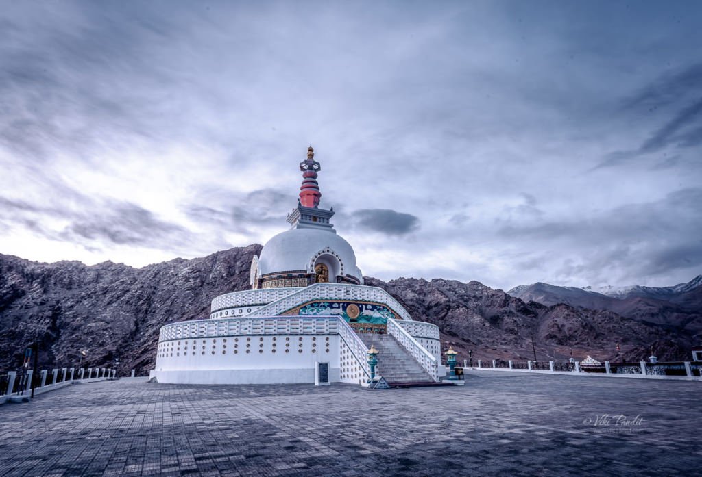
Shanti Stupa is one of several must-visit destinations in Leh. Surrounded by lofty mountains it has a special place in the cultural history of Ladakh. This white-domed Stupa on a hilltop in Leh was conceived by Japanese Buddhist Bhikshu, Gyomyo Nakamura as part of the Peace Pagoda mission.

Walk to Shanti Stupa

We had spent the earlier part of the day exploring Namgyal Tsemo Gompa and Leh Palace. All the walking had left us tired. We took a brief rest at the Shaolin Guest House, and then towards early evening, left for the peace pagoda.

Shaolin Guest House lies a couple of kilometers east of the Shanti Stupa. We walked down Sankar Road and then onto the Shanti Stupa Road. The walk is not difficult but it is not recommended for tourists coming from the plains as they might experience breathlessness because of the high altitude.

It is advisable that you take the first day off and just relax. It will help your body to acclimatise to the thin air in Leh.

Midway through the walk we were greeted by the picturesque Poplar trees. With its towering height, the Poplars stand distinctly in the landscape of Leh. These Poplar trees are said to mature very quickly growing up to 8 feet in the very first year. In the barren desert with almost no vegetation, the brilliant green trees are a sight for sore eyes. On the way, we passed by many small single-floor houses, some made of bricks and some of mud. The boundary of these dwellings are marked with medium-height ash-colored brick walls.

As we reach the outskirts of the city, the road starts to go uphill and the houses gradually disappear. The evening was breezy and we didn’t feel any discomfort hiking up the hill.

The Shanti Stupa road would be the easiest way to reach the Stupa. The motorable road leads right up to the gates of the Stupa. One can also reach here by climbing near-500 steps from the opposite side of the hill but in my opinion, it is not a recommended route for the unfit.

It was 7 pm by the time we reached the entrance of the Stupa. The Sun had hid behind the mountains but the light was still great. Situated on the hilltop at Changspa at a height of 4267 meters, the Stupa provides wonderful panoramic views of the surrounding mountains.

Buddhism in Ladakh

It is said Buddhism penetrated Ladakh during the time of Emperor Ashoka in around 204 BC. But even before the reign of Ashoka, the Arhat Majhantika blessed these lands with his visit and prophesied this region becoming a stronghold for the Buddhist religion in the Himalayas. Ladakh was in those times known as Mar-yul (Red Land).

It cannot be denied however that it was during Ashoka’s reign that Buddhism spread rapidly and took a stronghold in this part of the world. The indigenous community which were mostly nomadic and lived off meat at that time, gradually absorbed the concept of vegetarianism that is still followed today.

The reign of Ashoka also introduced the religion in Japan. The teachings of Buddha aroused new consciousness in the people of Japan and thus rose Todaiji, the greatest of the Buddhist temples in the world. And this brings us to the Shanti Stupa which stands for Leh as a mark of the friendship between two countries connected by a religion of peace.

History of Shanti Stupa

The idea of Shanti Stupa has its roots in a vision conceived many years before by Nichidatsu Fujii. Nichidatsu Fujii [1885-1985] more commonly known as Guruji, was the founder of the Buddhist religious order, Nipponzan Myohoji, which is dedicated to working for world peace through Peace Walks and the construction of Peace Pagodas across the world.

Around 1842, repeated invasions of Ladakh by the Kashmiri rulers shook Buddhism at its roots. Led by Maharaj Gulab Singh, the Dogra rulers undermined the aristocracy of Ladakh and brought about what is regarded as the darkest hour in the history of Buddhism in Ladakh. Alien to the local culture, they did considerable damage to the gompas and the stupas in the region. As a part of his mission to resurrect Buddhism back in Ladakh Bhikshu Gyomyo Nakamura conceived the idea of building the Shanti Stupa in Leh.

Shanti Stupa in Leh

Construction of the Shanti Stupa began in April 1983 under the supervision of Bhikshu Gyomyo Nakamura and Kushok Bakula, a lama from Ladakh. The project was built with the help of Ladakhi Buddhists, who offered voluntary labor, and Japanese Buddhists, who consider India as the “sacred” birthplace of the Buddha.

The Shanti Stupa holds the relics of the Buddha at its base, enshrined by the 14th Dalai Lama. The 14th and current Dalai Lama, Tenzin Gyatso inaugurated the Shanti Stupa in August 1991 celebrating 2500 years of Buddhism.

The beautiful Stupa today stands as a symbol of the friendly ties between the people of Japan and India. Since its inauguration, Shanti Stupa has become a popular tourist attraction. The Stupa overlooks the city of Leh, providing panoramic views of the city, the village of Changspa, Namgyal Tsemo in the distance, and the surrounding mountains.

Depictions of Buddha at Shanti Stupa

We waited for the dusk to arrive hoping the tourists would clear by then. Far away we could see the sun set over the lovely city of Leh. Mountains are the crowning glory of the region, as they stand tall, overpowering, and majestic in myriad colors.

The Shanti Stupa features a photograph of the current Dalai Lama with the relics of the Buddha at its base. The Stupa is built as a two-level structure. The first level features the central relief of Dharmachakra with deer on each side.

As we move up the stairs we face the central structure that features an image of Lord Buddha in golden color sitting on a platform turning the Dharmchakra wheel.

On the same level, as you walk around the circular path, we can find three other images depicting the birth of Buddha, the defeating of devils in meditation and the death of Buddha along with many small images of meditating Buddha, embossed in vibrant colors.

Both levels feature a series of smaller meditating Buddha reliefs along the walls of the central structure.

And the most important of all the Nirvana tablet that features the Buddha lying on his right side with his head supported by a pillow or his propped-up hand and elbow. Though this representation of the Buddha can indicate sleeping or resting, it is most commonly a representation of the final moments at the end of the life of the Buddha.

Parinirvana is a Mahayana Buddhist festival that marks the death of the Buddha.

Called maha parinirvana, this transitional state occurs only to those who have reached enlightenment, or nirvana, during their lifetime. Those who achieve nirvana are released from samsara, the cycle of rebirth, and karma. Instead, when they die, they reach nirvana-after-death or the eternal Self. It is also known as Nirvana Day and is celebrated on February 15th. Buddhists celebrate the death of the Buddha because they believe that having attained Enlightenment, he achieved freedom from physical existence and its sufferings.

Evening at Shanti Stupa

Dusk was upon us and the lights along the Stupa were gradually lighting up one by one. The crowd had dispersed by the evening, allowing for a more tranquil experience in this remote yet captivating locale. The white-colored domed-shaped structure looked extremely beautiful during the night when it was illuminated.

It was dark soon and the sky was lit with a billion stars. The moon was nowhere to be seen even though the Amavasya (New Moon) had passed a couple of days back. On the way downhill a cafe was still open where we gathered some warmth with a hot tea and a bag of chips. It was late and we were the only guests at the dimly lit cafe.

The walk downhill was relatively easy. Although by that time it was pitch dark. The area is devoid of any street lights. Holding hands and armed with a torch we slowly made our way back to the Hotel. It was a walk that I will always remember.

In 1974, when Ladakh was first opened for tourism, around 400 to 500 tourists used to visit a year, and with time the numbers rose every year. Today in 2018, around 6 to 7 Lakh tourists visit Ladakh every year. Tourism can be a double-edged sword. It can bring economic benefits but can also harm the environment and local communities. As a tourist, we must try to respect the local culture and not be disruptive to the environment.

Our upcoming schedule takes us to Nubra valley where if I am fortunate, I look forward to capturing some nice dunes. Your interest and interaction are incredibly valuable to me. Feel free to share your thoughts, comments, or questions – I would love to hear from you.

Visitor Information

Timings

The Stupa is open for tourists between 5:00 a.m. and 9:00 p.m

How to reach Shanti Stupa?

The Stupa can be reached by a drivable road or on foot using a series of 500 steep steps to the hilltop.

What is the most delicious food in Leh?

The most popular ladakhi foods are Thukpa (noodle soup) and Tsingmo (steamed buns).
When in Ladakh also enjoy the buckthorn juice which is indigenous to the union territory

What are the best restaurants in Leh?

Tibetan Kitchen and Gesmo are two of my favorite restaurants in Leh. If you are up for a coffee, you must try Lehvenda in the main market area. It is amazing.

Heritage walk to Vittala Temple

Today I went on a heritage walk to the majestic Vittala Temple. Built around the 15th century CE, and expanded several times by succeeding kings of the Vijayanagar empire, it is the epicenter of Hampi’s attractions. This time, I was in Hampi along with a trekking group from Bangalore.

It was another day of missed opportunities. I was awake at 5 am, ready for new experiences in Hampi. We were supposed to observe the sunrise from Anjaneya hill as per schedule but our trek leader himself got up at 6 am and by that time hiking up Anjaneya hill was a lost cause.

I wandered around the open spaces near our lodging. it was pleasant with no vehicular pollution or noises in the serene surroundings.

By the time everyone was ready, it was already 9 am. We drove down to Anegundi, the nearest town where we took our breakfast in one of the local dhabas. The idlis, served by a lovely lady were delicious. Just across the street, a wooden Rath was stationed. These chariot like structures are used during the rath festival in these parts.

From there the bus dropped us off near Talwar Gatta, where a ferry helped us across to the other side. Honestly, I was a bit scared, since they didn’t have any life jackets and one is always hearing about ferries toppling over in India.

History of Hampi

Hampi, believe it or not, the whole town is a UNESCO World Heritage Site. It was traditionally known by many names, the prominent ones being Pampapura or Pampakshetra. These names were derived from Pampa which was the name of the river Tungabhadra in those ancient times.

The recorded history of Hampi goes back a long way. Archaeologists have discovered rock edicts from the time of Emperor Asoka in Bellary, not very far from here, dating 269-232 BCE, suggesting this region could have been a part of the Maurya Empire way back in the 3rd century BCE.

Along-with the prosperity of the Vijaynagar empire, Hampi became a centre of religious and educational activities. But I would be biased to other dynasties if I only sing praises of the Vijaynagara kings. Hampi had already gained quite popularity by the 10th century. Inscriptions at Virupaksha temple, a kilometer along the Tungabhadra, are evidence to Chalukya kings making land grants to the temple.

Later between the 12th and 14th centuries CE, kings of the Hoysala Empire also built temples dedicated to the goddess Durga and lord Shiva. During this time, Hampi had almost become a secondary home of the Hoysala kings.

With time, it went on to become the epicenter of the Vijayanagar Empire in the 14th century. Chronicles left by Persian and European travelers, particularly the Portuguese, state Hampi was a prosperous, wealthy and grand city near the Tungabhadra River, with numerous temples, farms and trading markets.

By 1500 CE, Hampi was considered the world’s second-largest medieval-era city attracting traders from Persia and Portugal. Unfortunately, nothing lasts forever and the splendor of Hampi attracted many invaders. In 1565, the Vijayanagar Empire was attacked and defeated by a coalition of Muslim sultanates. Its capital was conquered, pillaged and destroyed by sultanate armies leaving the heritage city in ruins. It is said these invaders looted the city over a period of six months, snatching the valuables and burning all that remained to the ground.

History of  Vittala Temple, Hampi

After a short walk from the river, I found myself at the parking area for Vittala Temple. From here visitors can either wait for a buggy or simply walk to the temple, which is a bit of a distance away. A queue had already built up, so if you desire a peaceful experience please come early. While others in my trek group waited for the guide, I made my way to the temple.

The Vittala temple was originally built in the 15th century AD, during the reign of King Devaraya II (1422 – 1446 A.D.), one of the rulers of the Vijayanagara Empire. Many successive kings have expanded and enhanced the temple campus during their regimes to the present form.

Records from the 16th centure redfer to this complex as “Vitthala.” The temmple complex extends over a distance of about a kilometer. The temple was called the Vijaya Vittala predominantly. In one of the records, it is also mentioned as Kanada Vitthala. It is assumed that the “Vijaya” in the name Vijaya Vitthala indicates a celebration victory.

The road leading to the temple is in a completely ruined state. This road was once the location of a thriving market place. The market was known as the Vittala Bazaar and was famous for horse trading. The ruins of the market can be seen on both sides of the road.

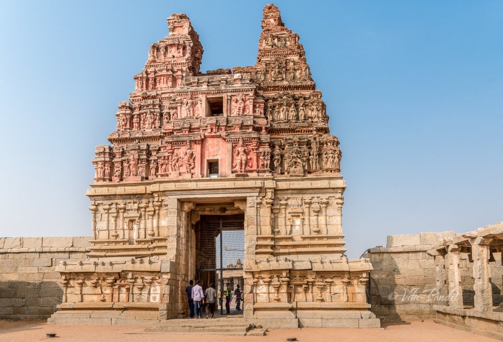
The buggy dropped me off near the entrance tower. One typically accesses the campus through the eastern gate, next to which the ticket counter is located. Behind the ticket counter lies the remains of a township called Vittalapura that existed around this temple complex. The first foundations of the temple were laid around 1505 CE. The eastern gate or gopuram was constructed between the years 1513 to 1516.

The Vittala temple complex

The temple is built in the form of a sprawling campus with compound wall and gateway towers. There are many halls, pavilions and temples located inside this campus. The iconic temple has amazing stone structures such as the incomparable stone chariot and the fascinating musical pillars.

The Vittala Temple is also known as Shri Vijaya Vitthala Temple. It is dedicated to Lord Vitthala, an incarnation of Lord Vishnu. An idol of Vitthala-Vishnu was enshrined in the temple.

Notable among the structures are the shrine of the Goddess (Devi shrine), Maha Mantapa or main hall (Sabha Mantapa or congregation hall), Ranga Mantapa, Kalyana Mantapa (marriage hall), Utsava Mantapa (festival hall), and the famous Stone Chariot.

The Vijaya Vitthala temple is a stupendous creation of the Vijayanagar artists with few paralells in the architectural history of medieval India. The main attractions of the Vittala Temple are listed below:

Stone Chariot of Vittala Temple

The first structure I noticed was the sculpted Stone Chariot, which is considered to be the most stunning architecture of the Vijayanagara kingdom. Designed in the shape of an ornamental chariot with the idol of Garuda, it is an iconic landmark of Hampi. The structure is classified as a Karakkoil, a temple fashioned after temple chariots which are taken in procession around the temple during festivals.

The Stone Chariot or Ratha stands in the courtyard of complex and welcomes the visitors as they enter the temple grounds. Even though it appears to be one, the Stone Chariot is not a monolithic structure. As per Hindu mythology, Garuda is the carrier of Lord Vishnu and its image is enshrined into the sanctum. The popularity if this iconic sculpture has led to it being part of the Indian currency in the denomination of Rupees fifty.

The stone chariot may be the first structure see as you enter the Vittala complex, but it is also the most recent.

Just like the Shore temple of Mahabalipuram, this shrine was also built with blocks of granite. The joints are cleverly hidden in the carvings and other decorative features that adorn the stone chariot. The chariot was built on a rectangular platform. The base platform is adorned with mythical battle scenes chiseled into the granite on all sides.

The chariot is adorned with a set of four finely sculptured granite wheels. Though the chariot is not resting on it, the four giant wheels are extremely well detailed and good enough to compete with real life ones. A series of concentric floral motifs decorate the sides of the wheels. The platform, where the wheels rest, shows clamps were later added to fix it from moving around the axis. Some older pictures of the stone chariot show it with a shikhara and the kalasha which have now eroded away. The wheels of the stone chariot are said to be once functional and could be rotated by the people. But some years ago the ASI cemented the wheels in order to avoid causing damage to them.

In front of the chariot two elephants are positioned as if they are pulling the chariot. However if you look carefully, you can see the difference in the style of sculpting. These elephants were supposedly added at a later stage after the chariot was completed. Originally two horses were carved in that position. The rear legs of the horses can be still seen just behind these elephant sculptures.

Maha Mandap of Vittala Temple

On leaving the Stone Chariot, I walked down to the main hall in front of the Vittala temple. Unfortunately the entrance to the Maha Mandap was blocked for maintenance. The first time I was here a couple of years back, people used to be allowed inside the main hall.

The Maha Mandapa or main hall of the Vittala Temple is situated in the inner courtyard, bang in the center of the temple complex just behind the Stone Chariot. It is a structure of immense beauty, sitting on a highly ornate base carved with a series of floral motifs. Maha mandap along the axis of the main temple has a pillared hall with three entrances. A series of steps flanked by elephant balustrades gives access to this elevated open hall called the Maha mandap.

The balustrades on the east and west porch of this hall is more dramatic with giant lion Yalis fighting the relatively dwarf elephants.

There are forty pillars lining the facade of the temple. The central part of the Maha Mandap has sixteen intricately decorated pillars having beautiful sculptures of Narasimha and Yali.

These richly carved giant monolithic pillars set of sixteen pillars forms a rectangular court. The sikhara of the Maha Mandap is very much in ruins, more so because it was created out of mud bricks.

The Musical Pillars of the Maha Mantapa:

The Dolotsava Mandap is other main attraction of the Vittala Temple. The most outstanding components of the Vijay Vitthala Temple is the eastern pavilion of the Maha Mandap.It was originally called Dolotsava Mandap or “Hall of Musical Pillars” This large mandap is renowned for its 56 musical pillars carved out of huge single pieces of resonant stone. This cluster of musical pillars are also known as SAREGAMA pillars, named after the notes of the classic Indian music – Sa, Re, Ga, Ma, etc. It is said musical notes are emanated when the pillars are tapped gently.

The original foundations of the Dolotsava Mandap were laid sometime during the reign of two Devarayas (1406 – 1446 CE ) of the Snagama Dynasty. It experienced further expansion during the time of Tuluva Krishnadevaraya (1503 -1528 AD) It was further expanded upon during the reigns of Achyutdevaraya( 1529 – 1546 AD) and Sadasivaraya (1542-1565 AD)

The analysis of these pillars has revealed that the rocks are resonant because of the presence of metallic ore and large amounts of silica.

The base is decorated with carvings of warriors, horses, swans and several other ornamental designs. The lowermost of it is a chain of horses, its trainers and the traders.

Every main pillar is surrounded by 7 minor pillars. These 7 pillars emit 7 different musical notes from the representative musical instruments. The notes emanating from these pillars vary in sound quality depending on whether the instrument is a percussion, string or wind instrument. When one of the columns is struck, the reverberation moves though the other nearby columns. However, if you find yourself at this site on a Sunday afternoon, forget about being able to hear any music over the ‘hum’ of the large crowds that throng this temple.

The emission of musical notes from stone pillars was a mystery that fascinated many people down the centuries. After conquering the region, the Mughals tried to burn down the temple but it turned out futile since the temples were carved out of granite.

After the Mughals, the country fell prey to the British. They too tried to damage the temple every way they could, pillaging away any artifact that could be carried away to their country. Two of these pillars were cut off by the British, who were surprised by the musical notes of the pillars and wanted to examine them in more detail. However, they found out that the pillars had nothing inside them.

I believe that tapping the musical pillars to emit musical notes is now prohibited, as tapping over the years have caused some damage to the musical pillars of the Maha Mandap. But the local guides fake it on the pillars of the other mandaps to please the tourists.

Most of the granite and sandstone towards the base have survived. The influence of Srivaishnava sect is seen at this temple complex which is revealed by observing minor shrines to the south, west and north. Around this main mandapa are four smaller halls: (clockwise from east)

  • Kalyan mandap
  • 100-columned mandap
  • Amman shrine and
  • Bhoga mandap

After capturing the exteriors of the Maha Mandapa, I moved towards the Kalyan mandapa on the left.

Kalyan Mandap

You can find more pictures of the Kalyan Mandap here.

100 Pillar Mandap

The “Hundred Pillared Hall” has altogether 108 pillars in all. It is said to be commissioned in 1554 AD. Below are close-up shots of some of the pillars.

Amman shrine

From the 100 column mandap, I made my way towards the back of the Maha Mandap where a small temple lies un-bothered and unattended by tourists.

Bhoga Mandap

For some reason they built a second marriage hall in the temple grounds. Generally all the temples I have visited only have one Kalyan Mandap. It might well have been for some other reason, the facts of which have been lost to time.

Some other interesting structures around the temple complex

While walking around the complex, I found this lone tree on the grounds. Beside the tree, along the enclosing walls lies a small structure. It is not very decorated and I am not sure about its functionality either, but it looks beautiful. I recall this from the first time I visited Hampi in 2014.

A few steps ahead lies the northern gate. Like the other structures, the base is very much as it was centuries back, but the top parts created using mud are in ruins.

Ruins of Vittala Temple in Hampi

The Vittala Temple is in a partially ruined state. The sanctum of the temple once contained an idol of Lord Vittala. However, now the sanctum is devoid of any idol. The region around the Vittala temple was called Vitthalapura. It hosted a Vaishnava matha (monastery), designed as a pilgrimage centred around the Alvar tradition.

According to historical memoirs left by Portuguese and Persian traders, the city of Hampi was of metropolitan proportions and the Vitthala temple the crown jewel of the kingdom. I have written another article on the still standing ruins of Hampi if you would want to read about the humble beginnings of the forgotten city.

In 1565, at the Battle of Talikota, a coalition of Muslim sultanates entered into a war with the Vijayanagara Empire. They captured and beheaded the king, followed by a massive destruction of the infrastructure of Hampi. The city was pillaged, looted and burnt for six months after the war, then abandoned as ruins. The central western hall of the temple was ruined during the attack of the Delhi Sultanate that eventually led to the downfall of the Vijayanagara Empire in 1565 CE and the end of Hampi.

I have been to Hampi twice and yet it feels like I have to come back many a more times to truly capture its essence in full. I was prepared to stay another day, but the living conditions of our lodgings forced me to catch the bus and head back to Bangalore.

Thanks for reading. Please leave me a comment if you liked the post or follow my story as I visit the mythical birthplace of luv & kush from the epic tale of Ramayana .

Festivals at Vittala Temple in Hampi

The temple has floodlights installed inside the temple complex. The lights illuminate the Vittala Temple Complex at night and offer a majestic view of the beautiful structure against the dark night sky. But if you want to see it, you should come in winter when the days are small. In summers the place closes up well before sunset.

Hampi Festival (November)

This is the largest festival at Hampi. Generally they are scheduled for 3 days during the first week of November. The celebrations typically packed with shows of music, dance puppet shows fireworks and a pomp procession as the grand finale showcasing the cultural richness of the place.

Purandaradasa Aradhana (January/February)

The annual Purandaradasa festival is held at the temple complex. The festival is held every year to commemorate the birthday of the ancient poet Purandaradasa who lived in Hampi. The 2-3 days long program is scheduled during the months of January or February.

Use of tripods is not permitted inside the temple campus.

The monument opens from 8.30 am in the morning to 5.30 pm in the evening. However, try to visit this place soon it opens in the morning. That is the only time you can explore peacefully before the crowd builds up.

Admission fee is Rs 30 for Indian citizens and Rs. 500 for foreign nationals. Preserve this ticket. If you are in Hampi for the whole day, you can use the ticket on the same day to also enter the Zenana Enclosure area.

Built

Early-to-mid-16th century

Built by

King Devaraya II

Admission fee

₹30 for Indian citizens / ₹500 for foreign nationals

Timings

8:30 – 17.30 hrs

Terracotta Temples of Bishnupur

Winter has been quite foggy this year. We had been planning a trip to the Terracotta temples of Bishnupur for some time but the dense haze had been putting us off. This weekend it finally relented somewhat and we grabbed the opportunity.

We started at a bit late at 9 am. The early morning fog had dissipated by then. From Kolkata, we drove up the Grand Trunk Road up to Burdwan. All along the Grand Trunk Road one can see endless potato fields. There are two toll booths on the way, each charging Rs. 75 for a car. At Purta Bhawan crossing in Burdwan, we turned left, taking the Ahilyabai Holkar Road road, straight to Bishnupur. We had made quick headway along the Durgapur Expressway where the roads are great. But as you turn into the road to Bishnupur, the roads are not that good. On this stretch of road towards Bishnupur, the potato fields gave way to fields of yellow flowers of mustard. It is also surprising to see the contrast, in terms of development along these small towns/villages. It is disheartening to see the stark disparity in development between the urban concrete jungle of Kolkata and these mud-house villages just outside of the city.

From the expressway, It took us about another hour of driving alongside beautiful mustard fields till we finally reached Bishnupur at around 1 pm.

Bishnupur is a small town not more than 400 sq km. For almost a thousand years it was the capital of the Malla kings of Mallabhum, till their power waned with the advent of British rule in India.

The Malla Dynasty

The history of Bishnupur can be traced back to 694 AD, when Adi Malla founded the Malla dynasty. However, it was much later in 994 AD that the place was named Bishnupur, derived from the name of the name of the Hindu God ‘Vishnu’.

There is an interesting story behind how Adi Malla ascended the throne. His father was a Rajput prince who was on a pilgrimage to the shrine of Jagannath in Puri. In his pursuit, he took along with him his pregnant wife. While they were crossing the great forest at Laugram, near Bishnupur, the princess went into labor. She died during childbirth. The remorseful king surrendered his infant child to the local villagers and left. The newborn was raised by a woman of the Bagdi caste who used to reside near the forest.

The boy grew up among the low-caste tribals, working as a shepherd. Many stories can be heard floating around the town, how once, this boy fished out a golden insignia from the river or when a huge cobra was seen standing over him shielding him from the sun when he fell asleep in the forest herding cows. A Brahman priest noted that the royal child was different from the rest of the Bagdi boys and took him under his care. The child grew up in the Brahmin’s house. In his care, the boy was imparted with good education along with physical and warfare training. By the time he was 15 years old, he not only excelled in education but also turned out to be an outstanding wrestler. People started calling him Adi Malla (Malla meaning wrestling), because of his wrestling prowess. 

When the then Raja of Bishnupur died, he left no heir to the throne. The Brahman was invited to the funeral feast (Sraddha). and he took the boy with him. During the Sraddha, to everyone’s amazement, the dead king’s elephant lifted the boy from the rows of spectators and placed him gently on the throne.

Soon on the request of the local elders he ascended the throne of the local kingdom, which was renamed as the Malla Kingdom.

The Malla Kingdom flourished and after about 300 years the 10th Malla King, Jagat Malla decided to shift his kingdom to Bishnupur. Over the next 800 years Jagat Malla and his descendants built several temples and structures turning Bishnupur into a temple town.

Of all the Malla kings, the credit primarily goes to the patronage of Raja Veer Hambir and his successors Raja Raghunath Singha Dev and Bir Singha Dev who made Bishnupur one of the principal centers of culture in Bengal. Most of the exquisite terracotta temples for which town is justly famous were built during this period in the 17th century.

Temples of Bishnupur

Bishnupur contains an interesting mix of terracotta and stone temples. The temples of Bishnupur are located in a small compact area and it is best to explore them by a combination of walking and self-driven cars. Toto rides are also available and they can guide you through all the temples.

Madanmohan Temple, Bishnupur

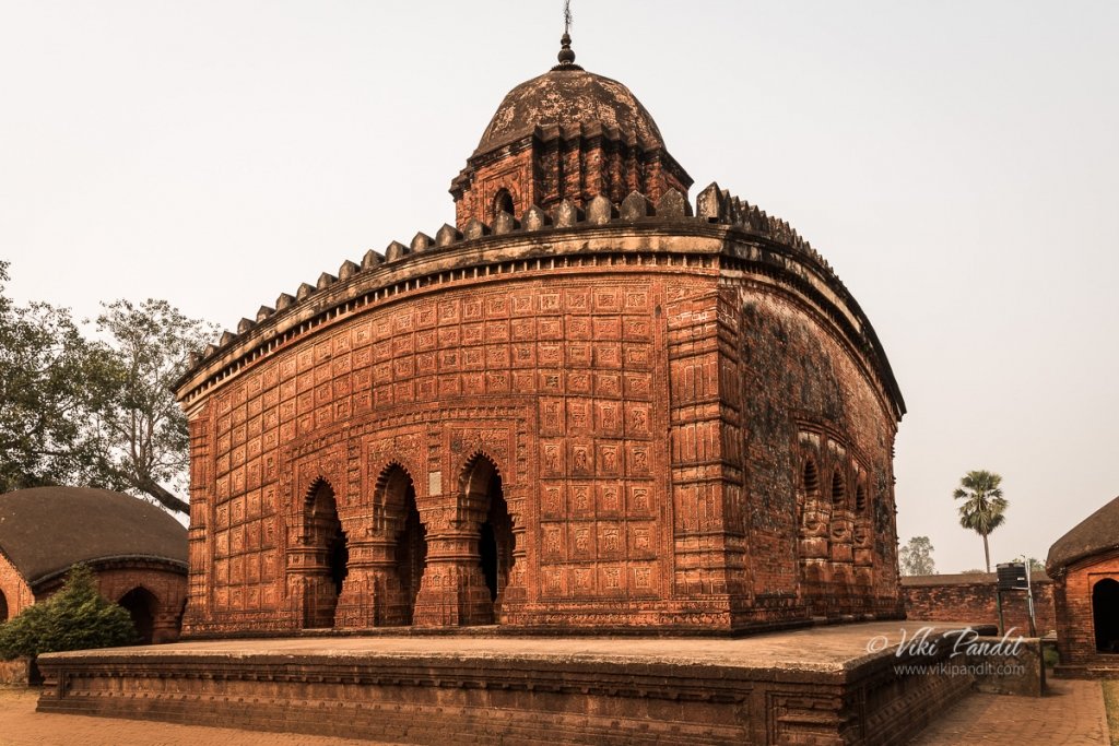
The Madanmohan temple was the first architecture we encountered. This single pinnacled temple has some of the finest terracotta in the whole of Bishnupur.  Built in 1694 CE by Malla King, Durjana Singh Dev. The star attraction of Madanmohan is its intricate terracotta artwork along all the four walls of the temple, that are still intact.

The temple stands on slabs of rusty-red colored laterite stones, found in abundance in this region.  It is dedicated to Lord Madanmohan (an incarnation of Vishnu) and is still an active temple. Entrance is free to this temple. Scenes from the Mahabharata, Ramayana, and the Puranas are depicted on the temple walls on terracotta panels.

We paid our respects to the deity at the temple and headed towards the Ras Mancha.

Ras Mancha, Bishnupur

The Ras Mancha is about 5 minute drive away. Built in 1600 CE by the Malla King Hambir, the Ras Mancha is the oldest standing brick structure of Bishnupur. Consisting of arched entrances separated by pillars the Ras Mancha stands on a raised, red colored, laterite stone platform and is crowned with a stepped pyramidal structure. The structure is absolutely unique in style and architecture, not only in Bengal, but in India. The pyramidal summit is constructed of baked bricks while the podium is created out of  laterite rocks, cut into brick-like shapes. The square base is about a meter high and the structure itself rises to about a height of 10 meters. The platform composed of laterite rocks show little weathering. However, the walls  and the supporting columns are gradually decomposing because of the chemical change due to surrounding pollution.

The Archaeological Survey of India (ASI) maintains most of the sites of Bishnupur and it levies a minimum entry fee for the sites. The amount is Rs 10 for Indian citizens and Rs 100 for foreigners. With this ticket, one can visit all the sites of Bishnupur maintained by ASI. The counter is located near the entrance of Rash Mancha.

The Ras Mancha was designed to be a gallery used to display art during the Malla regime. The main motive behind the making of this enormous construction was the festivity of the ‘Ras Festival’, when portraits of deities from the neighboring shrines or temple were created and then arranged for display here in the open doorways for common public. This ceremony was put into exercise during the Malla Rule and now the hallowed corridors stand without a purpose. In my travels, I am yet to see a structure that can be suggested to be of a similar nature in architecture or purpose as to the Ras Mancha. I can safely say, it is architecturally unique and one of its kind in the whole of India. Apart from a few floral lotus motif the Ras Mancha does not contain any terracotta art work. Walking the empty corridors are sure to give you a unique experience of walking in the past.

From Ras Mancha, we headed towards the Shyamrahi Temple.

Shyamrai Temple (Pachchura Temple), Bishnupur

We stopped at a narrow dusty path that lead up to the Shyamrai Temple. As we got down, on the right we could see a placid square tower like structure called Ghumghar of maybe two storeys, with no windows, located atop a small mound. Nothing much is known about the construction date and the purpose for which it was built. It is hard to ascertain the usage of such a building. It is likely it was used for storage or maybe solitary confinement of a small number of prisoners.

We left the car there and walked left towards the Shyamrai Temple, popularly known as the Pachchura temple, because of its five pinnacles. King Raghunath Singh, commenced building the five towered Temple of Shyam Rai in 1643 with its superior figurines and floral patterns. Under his reign, terracotta gained further momentum.

The Shyamrai Temple contains terracotta on all its four sides including the inner walls and the pinnacles. Each of the four sides contains triple-arched entrance adorned with the Ras Chakra and love-making scenes of Radha-Krishna. Entering the complex is forbidden.

From Shyamrai Temple we got back into the car and headed for Jore Bangla. The area is very dusty and if you have dust allergies do come prepared. We kept our car windows up for most of the time in the terracotta town.

Kestorai Temple (Jore Bangla) , Bishnupur

A short distance away from the Shyamrai Temple is the Kestorai temple. The most powerful king of the dynasty was King Raghunath Singh Dev II, who ruled from 1626 AD. At that time the administration of Bengal was in the hands of Shah Jahan’s son Suja. He developed a close friendship with the Mughal king and there followed a period of peace when art and music flourished. It was during this period that the Kestorai Temple was erected.

It follows the jora bangla style of architecture and hence is popularly known as the Jore Bangla Temple. Jora Bangla type of temple consisted of two Bengal styled thatched roof like structure joined together. Unfortunately some repairs were going on and we couldn’t enter the complex.

The Jore Bangla temple built in 1655 CE is considered as one of the finest example of Bengal terracotta art. There are numerous panels covering a wide range of topics. Panels of ships and boats are quiet in the temple. There are also several panels from the two great epics but a panel depicting Bhishma in Sarasajya (bed of arrows) during the fight of Kurukshetra.

Just beside the Jore Bangla, a few minutes walk away is the Radhashyam Temple.

Radheshyam Temple

This Ek ratna (Single Pinnacled) temple is built over laterite stone. Radheshyam temple dating back to 1758 CE was constructed by the Malla King Chaitanya Singha. This temple is one of the “youngest” among the temples that were constructed during the heyday of Malla kingdom. 

The temple is enclosed with high walls and is entrance consists of a triple domed Islamic style gateway. The spire is cylindrical, with semi-spherical dome inspired from the then prevailing Muslim architecture. Because of the closeness of the Mughals with the Malla Kings we can see the convergence of two different styles of architecture in this temple. The crumbling stucco is most elaborate and aesthetically pleasing among the laterite temples in Bishnupur. 

Beside the Radheshyam Temple, one can find the Radha Laljiu Temple complex, somewhat in ruins.

Radha Madhab Temple

Built 100 years earlier than the Radheshyam Temple, the Radha Laljiu or the Radha Madhab temple follows a similar single pinnacled structure. Built by the Malla King Bir Singha in 1658 it is considered as the finest laterite stone temple in Bishnupur. Unfortunately it is badly maintained and the limestone coat has suffered erosion over the years. 

Form the Radha Laljiu Temple, one can see the stone gateway known as the Pathar Darwaja in a distance.

Patthar Darwaja

At a short distance from the Radha Laljiu Temple lie two gateways – the Bara Patthar Darwaja or Main Gateway of Bishnupur and the Garh Darwaja. The larger of the two gateways, built of laterite stone is known as the Patthar Darwaja (Stone Door). This gate once served as the northern entrance of the Royal residence and was built in the second half of the 17th century by Maharaja Bir Singha.

The double storied gate could accommodate troops and the narrow slits allowed the archers and the gunmen to fire their shots. 

Garh Darwaja

A few yards away from the Patthar Darwaja is a small stone gateway, which was also built in the same period. Although much smaller in magnitude, the Garh Darwaja is an arched terracotta structure with a plain exterior. Both the gateways are not protected by the ASI and is thus not well maintained. Cars, bikes use this historic monuments on a daily basis enveloping them in smoke and dust.

There are many more similar temples around the town but it was already 4 pm and we decided to head back. This time we took the shorter route crossing Arambagh. The traffic along this route is a lot slower and even though it’s a lot less kilometers, it took us the same amount of time to reach the city.

The most famous art form of Bishnupur is terracotta work. But the town has much more to offer. One can collect exquisite terracotta pottery, artifacts and even jewelery from local souvenir shops. The town is also famous for its Baluchari Saris. The silk strands are dyed separately and then put into a loom. One sari may have an entire episode from the Mahabharata woven into its border and Pallu.

It was really a treat making our way across this sea of terracotta architectures. It is a mystery why the terracotta architecture stayed bound to this area of Bishnupur only. These architectures deserve UNESCO status. The Archaeological Survey of India is doing a great job but it needs to do better at conserving our history many of which have already been turned to dust by the Mughals.

Photowalk to Ukimido Pavilion

Ukimido is a hexagonal gazebo over the Sagiike Pond in Nara Park. The park is generally crowded with tourists all through the day, but they usually stay away from this area. The airy structure in the middle of the pond, surrounded by herds of deer, is one place where I can find peace at any time of the day.

I have been to Ukimido in Nara several times before but never during the evenings. A few days before I came across a flier at the Nara Tourist Information Center that had a cover photo of the pavilion at night. It looked so immersive that I couldn’t miss photographing this lovely gazebo.

So, at around 5 pm I walked down to the park. I had with me some acorns that I had gathered at Nagoya Castle grounds. The deer love munching on these acorns.

On my way, I went past the meadows beside Todai-ji temple where the deer were busy munching on the green grass. I was a bit surprised to see so many gathered at a single place. A couple came running towards me hoping to get some tidbits. I fed them the acorns I had stuffed in my cargo pockets. The sun was on its way down, so I hurried towards the floating pavilion.

Ukimido, Nara Park

It was almost sun down by the time I reached the pavilion. Some elderly ladies were sitting inside the dimly lit structure. The sunset was playing its magic creating a blend of purple and orange sky.

I stayed around till the ladies moved away after having their fill of the enchanting surroundings. During the summer evenings the floating pavilion is illuminated and it feels very relaxing sitting in the center of the pond amid dimly lit lanterns. I took a few shots of Ukimido Pavilion until the sun had fully set.

Once I was done taking pictures, I went back the along same path towards home. With the fall due in a month, some of the trees had started to turn red already. The lanterns along the Sagiike pond lit up the trees casting a reddish glow over them.

Nara Park is lovely in the day, but its mesmerizing at night. If you are in Nara, try to visit the place at night. Kofukuji and Todai-ji grounds remain open all night. The five-story pagoda at Kofukuji looks like a painting with the moon rising behind. The Todai-ji temple closes at around 5-5:30 pm depending on the season but you can still enjoy the beautifully lit park surrounding the temple. On certain days Todai-ji does remain open during nights. I was lucky to visit Todai-ji on New Years Eve, one of the rare times when the temple is opened to the public at night.

Thanks for reading! In a couple of days, I go back to India but in these few months, I have been so captivated by the rich culture and traditions of Nara, that I am certain that I will be back soon to complete my understanding of this western island of Japan. I would love to know about your experiences. Please post your thoughts using the form below or connect with me on Instagram.

Photowalk to Suizen-ji Park

Today I traveled to Kumamoto almost 750 km away, to visit the lovely Suizen-ji Garden.

Suizenji Garden (水前寺成趣園) is a Japanese style landscape garden in Kumamoto. The garden is named after a Buddhist temple Suizen-ji that no longer exists on the grounds. The origins of the garden go way back to 1632, when Tadatoshi Hosokawa, the administrator of Kumamoto, built the Buddhist temple Suizenji. It was completed by 1670 and named Suizenji Jojuen which means “Garden of Elegance”.

Nara to Kumamoto

From Nara I took the local train up to Osaka. From Osaka I had to take another change-up to Shin Osaka, since bullet trains don’t have a stop at Osaka Station. From Osaka, I took the Hikari Shinkansen to Kumamoto. it’s a 5 hour ride even on the bullet train. A long ride like this can cost a fortune, but I was carrying my JR Pass. With the JR Pass I can travel unlimited number of times, anywhere in Japan on the JR line trains. It has been a great asset on my travels throughout the land of the rising sun.

The weather kept changing from a bright sunny to rainy and then misty as I passed prefecture after prefecture.

Inside the Shinkansen area of the Kumamoto Station, a huge face of Kumamon, the official mascot of Kumamoto welcomes you to the city. The Kumamon was unveiled in 2010 with the opening of Kyushu Shinkansen in order to promote tourism within the region. The mascot’s character is inspired by Kumamoto – the prefecture’s name literally translates into “bear origin”.

From the bustling station of Kumamoto, I changed to the local Hohi line, that dropped me off at the Shin-Suizenji Station. The train bound for Suizenji, leaves at regular intervals of 20 minutes and costs ¥‎210. Those with JR Pass can avail this ride for free. From the station however, it is still a 15 minute walk to the park.

Suizen-ji Garden

Google maps was playing up and it led me on a round-about way to the park. After a bit of searching I was finally able to find the entrance. A sweet lady dressed in Kimono provided me the admission tickets that cost ¥400.

Just beside the entrance one can find an Inari Shrine. A series of red Torii gates lead up to the shrine. Some of the Hosokawa family members are enshrined here.

In Japanese mythology, Inari is a god primarily known as the protector of rice cultivation. The fox, symbolizing both benevolence and malevolence, is sometimes identified with the messenger of Inari, and statues of foxes are found in great numbers both inside and outside shrines dedicated to the rice god.

After paying my respects at the shrine, I walked up the beautiful garden path lined with an array of miniature man-made hills. Just opposite to the shrine there is a miniature hill, made to look like Mt. Fuji.

Along the path, I crossed a small arched bridge to reach a pond filled with Koi fish. Three tiny islands float in the middle of the pond. The pond is fed by spring water from Mt. Aso, an active volcano in central Kyushu. As I went near the edge of the pond to feel the crystal clear cold water, a school of colorful Koi swam towards me searching for an afternoon snack. Unfortunately for them, I didn’t have any.

A few paces ahead I came across the thatched Kokin-Denju-no-Ma tea-house which was moved from Kyoto’s Imperial Palace to Kumamoto in 1912. A couple of Japanese were sitting inside. The tea house opens towards the pond. For people sitting inside the tea-house, the lovely pond looks like a picture frame. Pigeons were walking around just outside the tea house. A crane stood on rocks in the middle of the pond, making the scene even more exquisite. It’s a perfect place to relax and let the mind wander.

With the relentless Japanese summer sun beating down against my skin, I moved on, beyond the tea house, towards the beautifully trimmed pine trees on the other side of the pond.

It is said, the garden was landscaped to give the impression of views seen when traveling along the Tokaido, the 12th century highway between Kyoto and Edo (present-day Tokyo) .

The path up ahead, lined with an array of small green mounds are sure to please any nature lover. At Adachi Garden, I had made up my mind that it was the most beautiful garden. However Adachi Gardens can only be viewed from behind glass windows, so the feel of walking in such a beautiful garden just tilts my judgement towards Suizen-ji. The historical aligned, beautiful landscapes of this garden have led to it being acknowledged by the Japanese government as a site of historic and natural beauty.

Walking through, I came back a full circle back to the Shinto Shrine. On the right there are two statues of Fujitaka Hosokawa with Tadatoshi Hosokawa.

The garden covers an area of about 15 acres, reproducing the 53 post stations of the Tokaido, including the miniature Mt. Fuji, I saw earlier. Before I end the article, I want to share this most beautiful section of the entire park.

The garden is also home to a Noh theater, where Noh is performed in spring and fall ceremonies. It also contains the Izumi Shrine, built in 1878 and dedicated to the Hosakawa family.

It was evening, and I had about 6 hours ride in front of me to reach home. So, I went back to the Kumamoto station and caught the Shinkansen from there back to Shin Osaka.

As I made my may back to Nara, the lovely garden with its picture-postcard beauty kept lingering in my mind. The beautiful dusk only made my experience of the day richer.

The Garden is a slice of history and beauty put together in a tasteful combination. The Suizen-ji Garden is a must visit for anyone who loves nature and appreciates the cultural and historical aspects of Japan.

Don’t Miss

Ikinaridango: a mochi (rice) and bean paste cake which is popular in the Suizenji area

Admission Fees

¥ 400

Timings

8 am – 5 pm

Built by

Hosokawa family

Built in

1636 CE

An evening along Bandai Bridge

It was almost 8 pm by the time we arrived in Niigata. The JR Station, operated by East Japan Railway Company lies at the centre of Niigata city. 

We had our reservations at the Hotel Lungwood. It’s right beside the JR Station. In fact one doesn’t even need to go out of the station building. There is a corridor that connects directly to the hotel.

Niigata is the largest city on the Sea of Japan coast. The city is blessed with an abundance of nature, surrounded by sea on one side and mountains on the other. On the way we had been already treated to one of the most jaw-dropping beautiful sunsets.

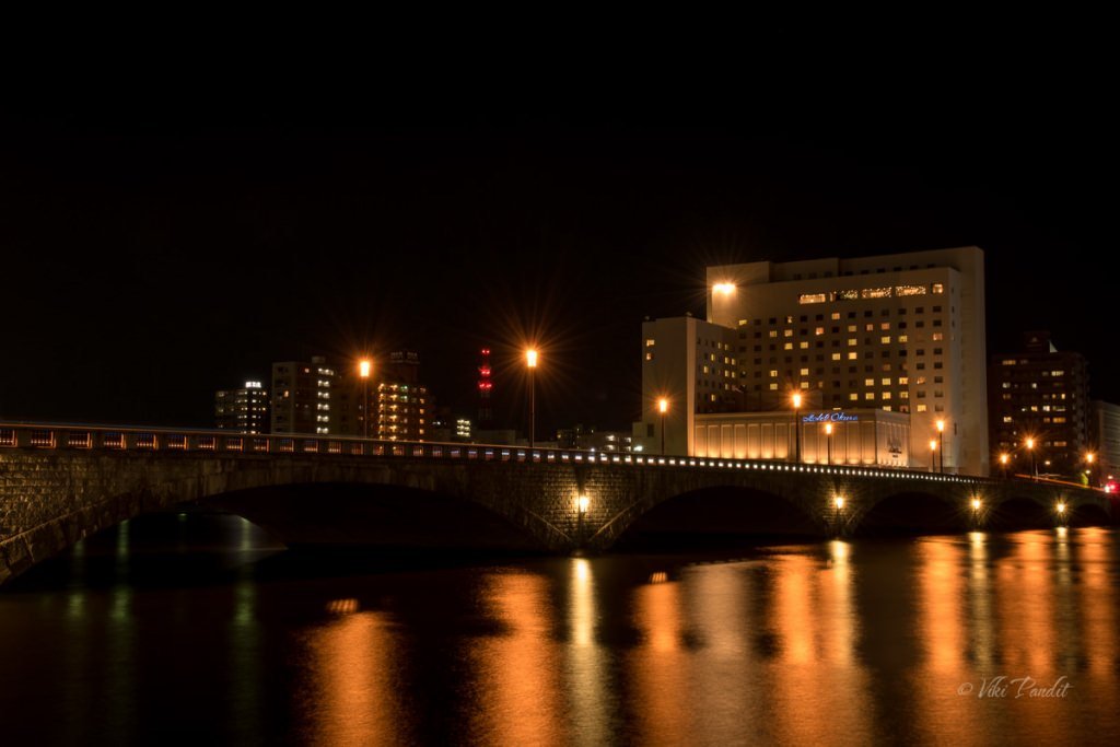
After dropping our luggage at the hotel, we went out for a walk towards Niigata city’s iconic Bandai Bridge (萬代橋) , a landmark that’s popular with both local residents and tourists alike. The bridge lights up at night, showing off its beautiful workmanship.

It was about 8 pm and most of the stores had closed for the night. We walked along the wide footpath following the trusted Google Maps. It took us about 20 minutes to reach the waterfront. The current Bandaibashi (as it is called in Japanese) was constructed in 1929, spanning the Shinano River in a continuous arch of reinforced concrete. In April 2004, the bridge celebrated its 75th anniversary and was designated as a national Important Cultural Property. This same year, much of the bridge was reconstructed to resemble its original model from 1886. 

The Bandai Bridge is a prime example of large-scale concrete arch bridges from the Showa Period. The current bridge contains six arches and is made of reinforced concrete with granite siding, and was strong enough not to collapse during the 1964 Niigata earthquake which destroyed large sections of the city. Today the Bandai Bridge is considered the symbol of the city of Niigata and is one of the city’s most scenic spots, especially when lit up at night. We stood there for some time enjoying the light show.

Towards the north of the bridge one can find the Furumachi and Honcho shopping districts, and towards the south, from where we came, lies the Bandai shopping district and Niigata Station.  Below the Bandai bridge there is an underpass that takes to the other side to a verge along the banks of the river.

Along the river bank many groups of people were lying down, enjoying the cool breeze flowing across the river. A few stalls of food and beer were still open. I guess this is a very happening area of the city and lots of people come down in the evening for fun.

We got us some grilled chicken from a nearby convenience store and sat on the soft carpet of green grass overlooking the silent river.

History of Bandai Bridge

The bridge lights had gone off at 9 pm but we were in no hurry to go back. The gentle breeze from the river forced us to relax for a bit more. The bridge has a long story with historical importance. The first Bandai Bridge was constructed out of wood in 1886, during the Meiji Period, and was the first bridge across the Shinano River.  Before it, people had to use boats for daily trade which was a big inconvenience. As the first bridge across the Shinano River, it encouraged trade between communities on the opposite banks. The original bridge was 782 meters long, the longest bridge in Japan at the time, and 2.5 times the current length as the river has grown significantly narrower since. After the destruction of the first two wooden versions, the third features a reinforced concrete design. 

In March 1908, a major fire destroyed more than half of the Bandai Bridge. The second Bandai Bridge was completed in December 1909, and quickly became the transportation hub of the growing city of Niigata. The new bridge was built using planks recovered from the remains of the 1908 fire as a base, and was the same size as the original design.

Due to gradual dilapidation of the second bridge, a third version was constructed in 1929 using reinforced concrete. Because of water diversion projects along the Shinano River throughout the early 20th century, the water level at the time of construction had decreased from 770 meters to 270 meters since the construction of the first bridge. Because of this, the third bridge was far shorter yet wider in order to allow for easy passage of automobiles.

On June 16, 1964, a magnitude 7.5 earthquake hit Niigata, causing major damage to nearly all bridges on the Shinano River. Although the base of the Bandai Bridge on both sides sunk approximately 1.2 meters, the bridge was left intact. 

In 1985, to celebrate the 100th anniversary of the first bridge, new lanterns were added to the bridge to decorate the night skies. A folk-dance procession is held annually as part of the annual Niigata Festival. 

It was almost 10 pm and the area wore a desolated look. The waterfront was still simmering with the lights from the buildings on the far side of the river. We gradually made our way back to the hotel. 

Please leave your comments if you enjoyed my journal or you can read about my visit to the Niigata Manga Museum.

Ruins of Sannai-Maruyama

Today I visit the ruins of Sannai Maruyama in Aomori. Discovered in 1992, the Sannai Maruyama Archaeological Site is the largest and one of the most complete and best-preserved Jōmon Period (13000-300 BC) village in Japan. 

Morioka to Aomori

I and my wife, Mani were on a short tour of Tohoku region. We were thoroughly refreshed from our previous day at Jōdogahama beach in Iwate. The day was bright and sunny as we checked out of our hotel and walked down to Morioka Station to catch the train to Aomori. As we entered the JR Station, we were quite pleased to see it was still decorated, in lieu of the just-passed Tanabata celebrations.

Tanabata originated from a romantic legend about two lovers that are only able to meet each other once a year. This festival is held across Japan on July 7 or August 7 depending on the region. It’s said that your wishes will come true if you write them down on strips of paper called the tanzaku and hang them on bamboo branches. We left a tanzaku wish note praying for a happy future at one of the booths.

The Shinkansen takes only an hour for the journey from Morioka to Aomori, however, Mani didn’t posses a JR Pass and in order to save some money, we used the limited express train. It was a long 3-hour journey but felt rather shortened by the animated chats about the places we were yet to explore around these parts. 

We reached Shin Aomori at 11 am. The Nebuta festival had just got over in Aomori, the previous day and the station was still adorned with many Nebuta floats all over the place. The Nebuta festival is one of the most popular festivals in Aomori and if you miss it you can always drop down to the Nebuta Museum to witness the amazing floats from the last held festival.

It was almost mid-day and the sun was burning bright, and although Aomori was cooler than Iwate, the strong Sun made it a tad uncomfortable. We left our luggage at one of the station lockers and waited for the bus for Sannai Maruyama site.

The sightseeing bus called Shuttle de Route Bus Nebutan-go arrived in a few minutes. The bus route keeps running in a loop all day, and to reach the Sannai-Maruyama site one has to get down at the Sannai-Maruyama-Iseki-mae bus stop. The ride cost us 310 Yen each.

Jōmon Jiyukan

As we entered the giant hall in Jōmon Jiyukan, the volunteers at the reception helped us out with the information about the heritage site. They provided us with a guided map of the area. Beside the reception, one can also find replicas of dresses from the Jamon period. Visitors are free to try on these Jōmon period clothing. I tried out a fisherman’s dress and I presume, I would have fit right in, into this traditional society 🙂

Once we had gathered all the information, we decided to first take our lunch and then proceed to investigate the huge site. The Gosennen-no Hoshi restaurant inside the campus serves delicious meals using prominent Jōmon ingredients. One can find a variety of set menus made of fish, vegetables and nuts that people during the Jōmon period used to consume.

I am generally a bit circumspect to try new food, but I decided to give it a try anyway. I ordered the “Shiokatsukune Udon.” The dish basically comprised of soft “Chicken meatballs” with bonitos (fish) and kelp soup. I did end up enjoying it and as I write this journal I can feel myself salivating just thinking about it. After the fulfilling meal at the Gosennen-no Hoshi restaurant, we slowly walked down to the Sanmaru Museum.

Sanmaru Museum

The Sanmaru museum exhibits objects excavated from the excavation site and lists many facts about the people who lived during the Jōmon Period. The Jōmon period encompasses a large expanse of time, constituting Japan’s Neolithic period and the museum exhibits approximately 1,700 artifacts excavated from the Sannai-Maruyama site. 

A dimly lit path led us towards a life-sized figure of a young boy with his Inu (dog), pointing us towards the glass encased cases of historical findings from the Jōmon period.

Jōmon no Kokoro

The first section of the Sanmaru Museum is called the Jōmon no Kokoro (heart of the Jōmon Period). This area displays various excavated items including a large number of pottery, stone artifacts, personal ornaments, clay figures, earthenware, wooden utensils, bone tools and small knitted baskets called “Jōmon pochette” from the Jōmon period.

Shown below is one of the stone tools from the site. This grinding stone was particularly used as a food processing tool. Nuts, such as chestnuts, walnuts, and Japanese horse chestnuts were an important source of food for the people at the time. These were used to crush these hard nuts. 

Below you can see some stone spearheads used by the hunters during that period. These hunting tools are characterized by a carefully formed leaf shape and evenly beveled edges that required great skill and patience to create. These tools were created by a process called knapping, where one stone is used to strike another to create a desired shape. If you are a student of history, you will notice that these stone tools, which were somewhat roughly created in the Paleolithic era, were by the Jōmon period meticulously chipped and smoothly polished. 

We moved forward to a large board-shaped clay figurine on display. The Sannai Maruyama village site turned up a huge number of human shaped figurines. From middle to late Jōmon periods, the Jōmon people made large numbers of human figures from clay. However these Jōmon figurines do not look like real people. They have distorted forms with large faces, small arms and hands. Some of the figurines look like humans wearing goggles. This is not new for many cultures who have depicted humans in exaggerated shapes like the Egyptians, but it does make one think if the Jōmon actually had some kind of extra-terrestrial contact.

The pottery vessels crafted in ancient Japan during the Jōmon period are generally accepted to be the oldest pottery in Japan and also among the oldest in the world. The word Jômon literally means “straw-rope pattern,” and it typically describes the style of pottery of the earliest Japanese period. The Jōmon period was named after this style of pottery.

All Jōmon pots were made by hand, without the aid of a wheel. As in all other Neolithic cultures, generally women created these early potteries. Clay was mixed with a variety of adhesive materials, including mica, lead, fibers, and crushed shells. After the vessel was formed, tools were employed to smooth both the outer and interior surfaces. When completely dry, these were baked in an outdoor bonfire.

Pottery found at this site is called Ento (cylindrical) style pottery. A typical Ento style pottery is characterized by an elongated bucket shape with a wide opening and is decorated with cord marks.

Below you can see different sized needles created from bones. In those times, animal bones were used to create harpoon heads, fish hooks, needles and even hairpins. Their varying length, thickness and the eye indicate that the Jōmon people developed them for specialized purposes. Most of the bone needles shown here are made of mammal ribs.

The image below is a cross-section of a mound. Many ritual associated implements were found from these mounds, suggesting the significance of these mounds as a ground for ceremonial activities

Most artifacts used in daily life such as pottery were made at the site using locally available materials. Ornaments include pendants and earrings made of clay, stone, and animal bones.  However certain items came from far away. Jade was favored by the Jōmon people and especially valued in north Honshu where Sannai Maruyama is located. In addition to complete artifacts such as large beads, raw stones have also been discovered here. 

If you want a guided explanation while looking at the exhibits, a volunteer from the Sannai-Maruyama volunteers will gladly guide you round the exhibits.

The Jōmon people of Sannai Maruyama

As we moved further, we were in the Jōmon-jin no Kurashi wo Himotoku (Lifestyle of the Jōmon Period people) section. Here life-sized figurines are used to reproduce the Jōmon daily life, based on excavated objects. The people in the early Jōmon period frequently traveled from one place to the next while engaged in camping and nomadic life. The Jōmon people primarily belonged to a hunter-gatherer culture. 

Over time the sedentary settlements appeared and certain communities engaged in cultivating plants. They gradually moved to a semi-sedentary lifestyle and descended from a mixture of the ancient hunter-gatherer Jōmon and the Yayoi rice agriculturalists. Their features can also be seen in the Ainu and Ryukyuan people. In fact, the Ainu have often been considered to be descendants resulting from a mix of the cultures of the Jōmon people and the Okhotsk. I have written a detailed report on the history of Ainu people.

Below you can see a typical Jōmon family gathering. The historical Ainu culture originated in a merger of the Okhotsk culture with the Satsumon, one of the ancient archaeological cultures that are considered to have derived from the Jōmon period cultures of the Japanese Archipelago. The origin myths of Japanese civilization extend back to periods now regarded as part of the Jōmon period, though they show little or no relation to what we know archaeologically of Jōmon culture, one of the reasons why the Japanese deny Ainu as the aborigines.

After about an hour of adoring the prehistoric artifacts, we moved on towards the excavation site. The Jiyu tunnel led us into the the largest ruins of a traditional village, dating from 4,000 to 5,500 years ago. Stepping into this region is like taking a step back in time.

A brief history of Jōmon People of Sannai-Maruyama

The Jōmon period experienced a large-scale climate change since it extended for a long period of 10,000 years. The Sannai-Maruyama Ruins are the largest ruins of a Jōmon-period (about 10,500-300 BC) village in Japan, and are estimated to date from 4,000 to 5,500 years ago. The Japanese archipelago is extremely elongated from north to south and its topography varies considerably; therefore, regional differences in the climate and vegetation were large during the Jōmon period as is today. As a result, the cultural style of the Jomon period is not uniform both historically and regionally and it came to take many different forms.

There have been previous excavations around the Sannai-Maruyama site between 1953 to 1967. These excavations involved teams from Keio University and the Board of Education of Aomori City. In 1976 and 1987, the Board of Education of Aomori Prefecture and Aomori City also conducted further excavations on the southern part of the site.

However, the major breakthrough for the site came in 1992 while excavating during a pre-construction phase for a baseball stadium. This excavation uncovered how large Sannai Maruyama was as well as a large amount of artifacts. 

After the excavation and study of the site, the village was reburied with earth and a number of reconstructed pit dwellings, long houses and a large tower were built on top. Visitors can enter the reconstructions, some of which are quite large, as well as see a few of the original excavation sites around the grounds.

A large number of pot shards and stone implements, clay figurines, jade beads, etc. were disposed together with the soil and formed a mound for over 1000 years. You can see its cross-section here. X-ray analysis shows that the jade excavated at ‘Sannai-Maruyama Site’ in Aomori Prefecture is from Itoigawa and therefore, it is assumed that the Jōmon people also traded among themselves over the wide area.

These findings demonstrate a change in the structure of the community, architecture, and organizational behaviors of these people. Because of the extensive information and importance, this site was designated as a Special National Historical Site of Japan in 2000.

Sannai Maruyama

Sannai Maruyama was first settled around 3900 BCE. At that time it was inhabited by hunters and gatherers only. Over this period of time, the site changed from a seasonal camp, to the home of a more mobile society, and finally to a settled village. Evidence of this sedentary lifestyle can be found in the the changes in their storage facilities.

Pit Dwellings

The earliest pit dwellings at Sannai Maruyama were during the Early Jōmon period, built between 5900 and 5400 years ago. At that time, Sannai was comparatively small and simple, a collection of pit dwellings. The first settlers on the site lived in pit houses. These dwellings typically were about 10 feet in diameter. The floor was dug below the ground level. A hearth was located in its center. At least 550 pit-dwellings have been discovered so far and 15 have been reconstructed. Some of the pit houses seen at Sannai Maruyama were simple thatched-roof semi-subterranean houses, like this reconstruction. To make this bark-thatched pit dwelling, a pit was excavated into the ground and bark or wood branches were assembled over the top forming a cone-like structure.

Over time the thatched pit dwelling was replaced with a sturdier structure as shown below. Like the thatched huts, the floor of a pit dwelling was dug into the ground. Supporting posts were placed at the corners and the walls and roof were built and roofed with thatch. The average size of these pit dwelling is between three and four meters in diameter.

Store Houses

Initially they used to store food in underground pits, which allowed them to hide it when they left the site since the occupants were not yet living a sedentary lifestyle.  With time, the storage features changed from these underground pits to elevated granaries around 2900 BC. These buildings were built higher than the ground level and were specifically used as storage facilities.

Long House

As the community became sedentary, long houses began showing up around this time. Long houses were large, oval-shaped structures. The longest one found at the site was 32 meters (105 feet) long. Scholars believe long houses were used for meeting places, workshops, or living space. Pit houses were still being inhabited for individual dwelling  at the same time that long houses started to come up on the landscape.

Till now eleven long houses have been excavated at Sannai Maruyama. They were large, oval-shaped semi-subterranean pit dwellings. The reconstruction  shown below is the longest, measuring 32 meters in length. This huge structure displays a coordinated labor force that would have required cooperation of several people to make. This displays the gradual shift from an individual to a social community in this time period.

Watchtower

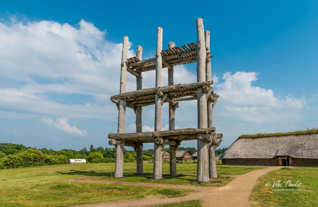
With a stable living style, also, there appeared one of Sannai Maruyama’s most famous structures, the large six-pillared building, was built around 2,600 BC.  This structure consisted of six large pillars that are believed to have held up platforms. Each one of these pillars was around 1 meter in diameter and was placed exactly 14 ft apart.  This large post like platform was certainly used as a watchtower. 

Burial Pits

Burials at Sannai Maruyama took three forms: jar burials, pit burials, and stone circle burials. Large jars have been discovered near the pit dwelling clusters. These are assumed to be burials, although human bones have not been preserved within them, on the basis of similar burials found in later Jōmon sites such as Yoshinogari. Jar burials have been dated to the Middle Jōmon period, from 5400-4300 years ago. The second form of burial was of adults aligned in rows along the sides of long roadways extending from the center of the settlement towards the outside. Finally as shown below, stone circle arrangements have also been found at Sannai Maruyama, which included adult burials. 

The settlement of Sannai Maruyama ended around 2300 BC.

By now we were extremely dehydrated. The harsh sun had taken its toll and we dragged ourselves to the safety of the Jōmon Jiyukan.

The vending machine at that moment was “gold” for us, as we gulped on the chilled sugary drinks.

The Sannai Maruyama site was designated as a special historical site by the Japanese government in November 2000. Today the public can visit this site and explore its many reconstructions. The site also features a Theater, a workshop and a gift shop. If you are in love with history do not miss this site. Even though at present, most of the excavated items have been reburied for preservation, the excavation sites and artifacts on display will giving you a feel of life in those ancient times.

Thanks for reading. Please leave me a comment if you liked the post or follow my story as we go for a stroll along the lovely Aomori Bay to witness a most alluring sunset.

Open Hours:

9:00 a.m. – 5:00 p.m.

Closed days:

December 30 – January 1
The center is also closed on the fourth Monday of each month. If that day is a holiday, the center will be closed the next day

Admission Fees:

410 Yen

Are baggage lockers available at the site?

Lockers are available for free. You need a 100 yen coin to lock them, but it will be returned when you retrieve your belongings.

Are all objects exhibited in the museum excavated in the Sannai-Maruyama site?

Yes. Sanmaru Museum exhibits approximately 1,700 artifacts excavated from this very this site.

Are there any restaurants at the site?

Yes, you can find a fine restaurant on the premises named Gosennen-no Hoshi, which offers specialty food prepared with Jōmon period recipes and also a kiosk called Hokusaikan.

Do you sell any books about the site?

Yes, many informative books are available at the museum shop as well as the kiosk.

A stroll to Jozenji-dori

Jozenji-dori is the soul of Sendai, the city of trees. Zelkova trees line the boulevard on both sides for about 700 meters, running east to west through the heart of the city. We were double lucky to be there at the time of the Tanabata festival when the entire road leading to Jozenji-dori was filled with colorful Tanabata decorations.

Our day starts from the quiet town of Tendo.

We took the train to Yamagata and from there caught the Shinkansen to Sendai.

Sendai Station was adorned with Tanabata decorations.

We were in the city for just a few hours, so we decided to take a walk to Jizen Dori, one of the popular tourist destinations in the heart of the city. The Sun was quite sharp as we came out of the station.

From the station, we followed the decorations along the streets as we made our way towards Jizen Dori.

There was a never-ending show of tanabata decorations and the streets were crowded as hell.

We kept following the decorated street.

Until we were finally at the popular statue of Jizen Dori

This is an iconic statue of Sendai

After resting for a few moments, we took a bus back to the Sendai Station.

We bid adeu to Sendai, as we left for Matsushima, our next stop in our tour of Tohoku.

Thanks for reading!

On the Urabandai Goshiki-numa Trail

Today we go for a hike along the Goshiki-numa trail in Bandai-Asahi National Park, that runs along five gorgeous ponds. These ponds were created by the eruption of Mt. Bandai in 1888, after which the volcanic minerals dissolved in the water, imparting each pond with its own shade of color ranging from green to whitish blue.

We were staying in Aizu-Wakamatsu and spent the previous evening enjoying a most lovely evening at Tsuruga Castle grounds. We rose up early to catch the local train on the Ban-Etsusai Line and reached Inawashiro Station at around 9 am. It takes about half an hour to reach Inawashiro from Aizu-Wakamatsu and the ride is free for Japan Rail Pass holders.

Goshiki-numa

Goshiki-numa (五色沼), is a cluster of five volcanic lakes and ponds situated at the foot of Mount Bandai in the center of the lake district of Bandai-kōgen, in Fukushima.

The prefecture of Fukushima is blessed with one of the most lovely countryside and the Bandai-Asahi National Park is the most beautiful feather in its cap. Visitors to the park can marvel at Mt. Dewa-Sanzan, which is famous as a site for mountain worship, gaze upon the peaks of Asahi, Iide and Mt. Bandai, or enjoy the beautiful sights of hills and numerous lakes and marshes from vantage points in the Urabandai area and Lake Inawashiro.

But none is more interesting than the Goshiki-numa Nature trail that walks you along five gorgeous ponds/lakes formed by volcanic activities in the region. These ponds were formed when the summit of Mount Bandai on the northern side collapsed due to a steam explosion. The subsequent rock avalanche blocked the river Aga, which led to the formation of numerous water bodies in this area. Goshiki-numa is just one of many such groups of lakes & ponds formed during the eruption.

From the Inawashiro station we took the Bandai Toto bus to the Goshikinuma-iriguchi bus stop. The bus takes about 30 minutes and will drop you right in front of the Urabandai Tourist Information center, which lies at the start of the Goshiki-numa Trail. The bus ride costs ¥720 (one way) and is not covered by the Japan Rail Pass.

The Urabandai Tourist Information center is large and well-equipped, and provides information not only about touring the area, but on the geography, wildlife and history of the area itself in various exhibits, including video. Urabandai (裏磐梯) literally means “behind Bandai” and we were told that at certain viewpoints we could see the peak clearly along with the ponds.

Sitting deep into the forest, this center provides luggage counters, maps and pamphlets in English as well as any other information you may need for the Nature walk. Toilets are also available at the center.

We dropped off our heavy suitcase at the center and after collecting the map of the Goshiki-numa area, we started on the walk.

Bishamon-numa

The first pond on the trail is the Bishamon-numa Pond. It was summer and the beautiful Ajisai was blooming. If you love Ajisai flowers, do visit Hase-dera in Nara for a brilliant show of blooms during summer.

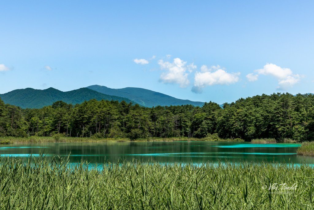
A little up ahead we found ourselves in front of a most beautiful teal colored pond, though in my opinion it looks more like a lake.

The colors of these lakes mysteriously fluctuate throughout the year with the weather.

On the Bishamon-numa, row boats are available for hire. People were enjoying the beautiful weather on boats along the pond.

After admiring the beautiful Bishamon-numa Pond, we moved forward along the trail shown on the map. The trail is clearly marked and it was quite easy to follow the directions.

There are several vantage points around Goshiki-numa where visitors can enjoy breath-taking views of Bishamon-numa Pond. I personally loved this view point below that catches the lovely colors of the pond with Mt. Bandai in the background.

From here the trail moved into a wooded area surrounded by thick foliage. We were followed by other groups of Japanese along the trail. In fact all along the route we kept seeing more and more people, so it seems it is a pretty popular spot during summers.

At certain points the wood becomes so thick, its hard for the sunlight to get through.

If you can get a little close to the pond, you can find colorful Koi swimming in the waters. Be sure to keep an eye out for the rare one with heart-shaped spots on its side which is believed to bring good luck!

After a while as we hiked up, the forest opened into a clearing. From here you can see a different angle of the Bishamon-numa Pond.

We gradually moved on along the stone path. It was also getting hotter as we were now into the afternoon.

Aka-numa

The next pond on our trail was the Aka-numa Pond (Red Pond) . Although the name highlights its reddish-ness, its color is much more of a muddy green. Due to the high iron content of water seeping into the roots of the reeds, it imparts a reddish tint to the edges of the pond.

Along the trail you can find different variety of flowers blooming near the pond.

In the below close up photo, you can see clearly the reddish reeds along the edge of the pond. After taking a few pictures of the Aka-numa Pond, we moved ahead.

We continued on our hike through the forest. Along the hike I noticed many carrying small bells, making a tinkering noise. I later came to know that those bells were to keep bears away. Yes! Bears!! I don’t feel so safe now :O

The area is supposedly famous for Asiatic black bears but we were luckily, we didn’t get to meet any of them today. Many hikers swear by bear bells as a good way to keep from accidentally running into them but I have read of several accidents involving bears in the Tohoku region where the bells were of little help.

About midway through the hike, we could hear the sounds of flowing water. After looking for sometime, we noticed this small stream of water flowing into a nearby pond.

Benten-numa

When we came out again in a clearing, a light aqua colored pond lay in front of us. It is called the Benten-numa (Benten is the Japanese goddess of the arts and wisdom. It is undoubtedly the second largest of the five ponds.

The trail goes in a semi-circular path around the pond with several viewpoints to capture the breadth-taking colors of the pond.

Benten-numa, too, is surrounded by quite thick foliage so is a little difficult to get a good look out over, but, like Bishamon, features a backdrop of Urabandai mountains.

We were soon back into the woods.

Ruri-numa Pond

We were soon at the Ruri-numa Pond (Lake Lapis Lazuli) . The Ruri-numa is named so for the deep, rich blue of its waters, which are probably the clearest of any of the Goshikinuma ponds.

It was here that I dropped my Nikon 810 for the first time. Yes, while entering this area, I slipped over the dusty rubble and lost my footing. It was a good thing that my Black Rapid camera strap kept the camera close to my body. Nothing happened to the camera except for some scratches on the bottom.

Fortunately the fall didn’t do much damage to this tank of a camera and I was able to keep clicking more pictures of this gorgeous lapis lazuli colored pond.

This was not as big as the other ponds

Yanagi-numa

From here the Yanagi-numa is not very far off. Yanagi-numa (“Willow Pond”) lacks the sludge-filled bottom of the other ponds, therefore it lacks the “magic” hues and tints. However, the water is very clear and faithfully reflects its surroundings, making for another special kind of beauty.

The water in this pond was of a natural color.

So there you have it – a pictorial tour of the Goshikinuma Nature Trail. From this last pond on the trail you can choose to go ahead where you can find a bus stop to take you back. We however had to go back as we had left our luggage at the Tourist office. so we went back quickly along the same trail.

Most tourists had left boating by the time we arrived back at the starting point of the trail – Bishamon-numa Pond

The bus arrived on time and we were back to the Inawashiro Station.

We were on our way to Tendo, we we would stay for a night before advancing to the next stop on our Tohoku tour – Sendai. We had a lovely day at Goshikinuma Nature Trail. The name, Goshikinuma, as written in Japanese (五色沼 or five color ponds), is rather a misnomer. The area consists of many more than five ponds, and is also famous for displaying a much larger spectrum of spectacular colors.

The ponds have earned the name “Mystic Marsh” due to this characteristic. The sightseeing trail around the ponds is 3.6 km long and takes approximately 70 minutes to walk. Urabandai is also popular for autumn color viewing. Due to the wide range of elevations, colors can usually be seen somewhere during the entire month of October.

Thanks for reading! I look forward to your comments and questions. If you are looking to explore more of the Tohoku region, follow my story as I make a stop-over at Sendai and then go for a cruise over the beautiful Matsushima Bay.