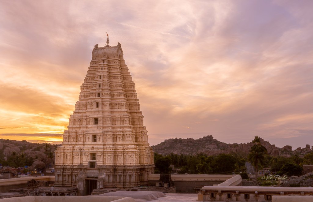
Ride to Kalo Dungar

I am at Kalo Dungar, some 50 km north of Dhordo tent city, on the top of the Black Hills. The highest point in Kutch, offers a bird’s-eye view of the Great Rann of Kutch. From here, the entire northern horizon vanishes into the Great Rann, the desert and sky becoming indistinguishable on the horizon.

Drive from Dhordo Tent City to Kalo Dungar

I and my travel companion – Mani, were staying at the Dhordo Tent city. Every year, the government of Gujarat holds a four-month-long festival known as ‘The Rann Utsav’ starting from November to February. The stay at the Tent city includes a free bus tour to Kalo Dungar.

The route to the hill is not very clearly marked. It is best to visit Kalo Dungar before sundown to avoid getting lost on the secluded roads leading to the hill. Our driver, though being a local, got lost twice and had to backtrack to get the bus back on the correct route. Although if you do get stuck at the hill, there is a dharamshala at the top where you can find shelter and basic food.

Even at 462 meters, the hill can still pose a challenge to the novice driver with roads inclined at very steep angles. Halfway up the hill, for a moment the bus driver almost gave up looking at the steep terrain.

Eventually, after a lot of coercing, laced with encouragement from fellow tourists, the bus reached the parking zone, which lies a little distance away from the top. From here local jeeps took us to the peak for Rs. 20 per head. It’s not much of a distance, probably just a way to allow the locals to make some earnings.

While going up, looking down from the back of the jeep, I realized that no bus would have made the drive to the peak. The jeep dropped us off in front of the Dattatreya Temple.

Just opposite the temple lies an Army outpost. This is one of the places where a civilian can get closest to the Pakistan border,  and there is tight security around the hill.

Dattatreya Temple on Kalo Dungar

The hilltop is also the site of a 400-year-old temple to Dattatreya, the three-headed incarnation of Brahma, Vishnu, and Shiva in the same body. Many fables and tales are associated with the history of the Kalo Dungar. One of them says that Dattatreya happened to pass by this hill while walking on the earth. While admiring the barren landscape, he found a band of starving jackals. He offered them his body to eat and as they ate, his body continually regenerated itself.

Some people differ saying that it was actually a holy saint named Lakkh Guru, a worshiper of Dattatreya who used to live there in an ashram. One day a pack of wild jackals appeared in his ashram and stood expectantly in front of him. When he realized that they were famished, he offered them a simple meal of rice and dal, the staple diet of his ashram. Since that day the jackals started coming each day, day after day.

Because of this, for the last four centuries, the practice of feeding jackals still continues to this day. The priest of the temple prepares food and serves it to jackals every morning and evening, after the aarti (praying).

Beside the temple is a makeshift tent selling Gujarati handicrafts and traditional dresses.

From here we were on foot, making our way upwards towards the topmost viewpoint. People with a disability or just plain unfit can avail the use of beautifully dressed Camels, who can carry them to the top.

The road though steep, is an easy walk and we were hardly challenged as we reached the top viewpoint within a few minutes.

In the distance, despite the haze, I was still able to make out the rectangular salt fields. These are the lands of the Agariya tribe, traditionally salt farmers, who have lived here for centuries. Working every day under a scorching sun from mid-October to June, the Agariyas harvest almost 75 percent of India’s overall salt produce.

Across the Black Hills, staring into infinity, one can realize the tremendous effort of the Sindh merchants, who undertook the crossing of the Great Rann for trade in the olden times.

Why is the Kalo Dungar called Black Hill

Well here is another interesting story. It is intriguing why the locals refer to this hill as the Black hill. There is not a point on the hill that is remotely associated with that color.

Though not literally black, the hill is known so because, in olden times, the merchants returning to Kutch from Sindh used to be guided by this lonesome hill in the grim desert, which used to appear black either because of the shadow cast by the sun or because of the dense forest cover. Just like the North Stars guides the lost people at sea, Kalo Dungar used to act as a marker so the caravans of people crossing the desert would follow it to understand their location.

There weren’t many tourists at the top. A cemented platform with makeshift benches provided relief to those who had tired from the climb. A small structure stood below us shaped like a hut with the words “Suswagatam” painted, which means “welcome” in Hindi.

We wandered around immersed in the beauty of the surrounding. Local kids in their teens would, from time to time, come around offering tea. A few of the brave-hearts had ventured beyond the cemented platform into a narrow trail that went further to the edge of the hill.

The Sun gradually slipped into oblivion. After taking a few shots of the picturesque landscape we started walking back towards the bus.

While driving back, there was a section on the road which our guide brought attention to. He reported that in that 4 km stretch of the road, vehicles roll down in neutral gear at speeds of 70-80 km/hr.

However, a quick search on the internet informed me that the movement of the vehicle is only because of the steep slope and there was no anomaly causing it. Experts from the Indian Institute of Technology (IIT), Kanpur and Institute of Seismic Research (ISR), Gandhinagar have concluded that vehicles suddenly gain speed in the descent only because of the steep slope. So much for the magic theory.

Going back was thankfully devoid of any adventure and we reached Dhordo in an hour’s time.

How to reach Kalo Dungar using public transport

Kandva village is the closest inhabited village which is located around 25 kilometers from Kalo Dungar. Reaching the hilltop by public transport is difficult; the only bus travels there from Khavda on weekend evenings and returns in the early morning. Hiring a jeep from Khavda is the better option. Bhuj is almost 90 km away and a day tour from Bhuj would be quite taxing.

People who want to see the Great Rann of Kutch from a different perspective must head up to Kalo Dungar. In my opinion, staying at one of the resorts in Dhordo is the best option for enabling a good experience of Kalo Dungar. The drive takes about an hour and one can stay a bit late after the sunset and still make it back to the resort quickly.

Thanks for reading. Please leave me a comment if you liked the post or follow my story as I visit Mandvi Beach on the Arabian Sea.

Sunset at White Rann

I am standing at the edge of the White Rann, an endless stretch of white that goes all the way from Gujarat’s Kutch district to Pakistan’s Sindh. The tattooed Camels have helped us reach this point from where everything is a blank white of nothingness.

The vast expanse of uninterrupted whiteness makes me feel as if I was miraculously zapped from the grim Indian desert to the frozen white lakes of Japan, only I didn’t need the safety of my hefty gloves or winter jackets. Oh yes, it looks like a frozen lake but looks can be deceiving. This is one of the most unforgiving places in India with summer temperatures averaging and peaking at 49.5 °C. Thankfully it is November when it is pleasantly warm.

Centuries ago, the Rann of Kutch was part of the sea until an earthquake turned the exposed sea bed into a sprawling desert. The name “Rann” comes from the Hindi word ran (रण) meaning “desert”. Today, it is a vast expanse of arid land, devoid of habitation, stretching out to the Arabian Sea.

The salt desert spreading over 30,000 sq. km gets submerged underwater during the monsoons. The Luni River, which originates in Rajasthan, drains into the desert in the northeast corner of the Rann. The Rupen from the east and the West Banas River from the northeast also feed freshwater into the desert, making it the world’s largest salt marsh.

Even though it was November the salt was still slimy and difficult to walk over. Just below the white salt lies gooey black mud. The Sun was dipping fast. Mani in her beautiful Ghagra was trying her best to help me take a shot of the sunset over the White Rann. I think I will talk about this photo for years to come.

The low-lying mudflats of the White Rann, which is all but 15 meters above sea level, fill with water during the monsoon between June to September, and then gradually dries out over the rest of the year leaving behind the saline crust that hardens to form the signature luminous white color of the desert. By January when temperatures reduce dramatically and can go below 0 °C, the marsh is transformed into an unending white desert.

In the wee hours of twilight, we were gifted with the sight of the Moon rising in the opposite direction. Most of the tourists had left by then and it was easier for us to take this shot via the tripod.

The salt desert is about 100 kilometers away from the nearest town of Bhuj and that allows the place to be free of random by-passers. There is a quietness to the place, allowing me to ponder. I even forget that I haven’t click a single photo of the white desert in its entirety. No worries there because I will be coming back.

We stayed back till the sun disappeared over the horizon and darkness engulfed us.

Our experience of Rann of Kutch was made even memorable by our stay in the premium tents of Rann Utsav. If you want to know more read the full story here.

Photowalk to Ukimido Pavilion

Ukimido is a hexagonal gazebo over the Sagiike Pond in Nara Park. The park is generally crowded with tourists all through the day, but they usually stay away from this area. The airy structure in the middle of the pond, surrounded by herds of deer, is one place where I can find peace at any time of the day.

I have been to Ukimido in Nara several times before but never during the evenings. A few days before I came across a flier at the Nara Tourist Information Center that had a cover photo of the pavilion at night. It looked so immersive that I couldn’t miss photographing this lovely gazebo.

So, at around 5 pm I walked down to the park. I had with me some acorns that I had gathered at Nagoya Castle grounds. The deer love munching on these acorns.

On my way, I went past the meadows beside Todai-ji temple where the deer were busy munching on the green grass. I was a bit surprised to see so many gathered at a single place. A couple came running towards me hoping to get some tidbits. I fed them the acorns I had stuffed in my cargo pockets. The sun was on its way down, so I hurried towards the floating pavilion.

Ukimido, Nara Park

It was almost sun down by the time I reached the pavilion. Some elderly ladies were sitting inside the dimly lit structure. The sunset was playing its magic creating a blend of purple and orange sky.

I stayed around till the ladies moved away after having their fill of the enchanting surroundings. During the summer evenings the floating pavilion is illuminated and it feels very relaxing sitting in the center of the pond amid dimly lit lanterns. I took a few shots of Ukimido Pavilion until the sun had fully set.

Once I was done taking pictures, I went back the along same path towards home. With the fall due in a month, some of the trees had started to turn red already. The lanterns along the Sagiike pond lit up the trees casting a reddish glow over them.

Nara Park is lovely in the day, but its mesmerizing at night. If you are in Nara, try to visit the place at night. Kofukuji and Todai-ji grounds remain open all night. The five-story pagoda at Kofukuji looks like a painting with the moon rising behind. The Todai-ji temple closes at around 5-5:30 pm depending on the season but you can still enjoy the beautifully lit park surrounding the temple. On certain days Todai-ji does remain open during nights. I was lucky to visit Todai-ji on New Years Eve, one of the rare times when the temple is opened to the public at night.

Thanks for reading! In a couple of days, I go back to India but in these few months, I have been so captivated by the rich culture and traditions of Nara, that I am certain that I will be back soon to complete my understanding of this western island of Japan. I would love to know about your experiences. Please post your thoughts using the form below or connect with me on Instagram.

The thrilling Tojinbo Cliffs

This day is special to me, today I can safely proclaim to be the second Indian to visit all 47 prefectures of Japan. The first Indian to explore all 47 prefectures is obviously my wife Mani san. I had been wanting to visit the cliffs since the day I witnessed the thrilling cliffs of Sandanbeki in Wakayama. My JR Pass was going to expire soon, so I made up my mind to drop in at Tojinbo today.

Tojinbo is a series of basaltic cliffs located within the Echizen-Kaga Quasi-National Park in Sakai, northern Fukui, bordering Ishikawa. Pronounced Toujinbou, the rugged, precipitous cliffs stretch for over a kilometer, and is designated as a precious natural monument.

I was a bit tired traveling more than 2000 km in the last couple of days. From Nara, it was a leisurely 40 minute ride to Kyoto. The trees on the hills along the route had started turning red with the advent of fall.

At Kyoto, I took the Thunderbird Limited Express to Fukui. Even though the Thunderbird is not a Shinkansen, the interiors are nothing less than one.

The train ride to Fukui goes along a hilly region and for most part of the journey we were traveling inside tunnels. It had started to rain strongly and I was keeping my fingers crossed hoping for a better weather at Fukui.

I reached Fukui at 1 pm. The weather here was much better. The tourist information booth had been shifted to a new place because of renovations. It took me a bit of time searching for the relocated office. Once I was there, the lady at the counter told me to catch the train to Awaraonsen Station and take a bus from there. There is another way using the Echizentetsudo-Mikuni-Awara Line to Mikuniminato Station, but it’s not a JR line. Both routes cost similar and take up almost similar time but I chose to go to Awaraonsen as it was a more preferred route.

At Awaraonsen, just outside the station is a bus ticket counter where one can purchase a round trip ticket to Tojinbo. One can save a few Yen by buying the round trip ticket that costs ‎¥1000. One way ticket to Tōjinbō costs ‎¥750 each way.

The bus for Tojinbo leaves every hour so I had to kill some time at the station. I wandered around the place but its a small town with nothing interesting around the station. There is a Seven-Eleven store inside the station premises, and that’s it.

The bus arrived at 2.40 pm. The cliffs are popular with foreigners and the bus stops are announced in English as well as Japanese.

It was about 3.30 pm by the time I reached the Tojinbo bus stop. The cliffs are at a 5 minute walk from the bus stop.

It was a breezy evening as I walked along the cobblestone path towards the cliffs. The path is lined on both sides by many omiyage (souvenir) shops and restaurants. The restaurants serve some delicious baked seafood in the restaurants. One can also enjoy the Squid Ink Ice cream, a specialty found only in the Tojinbo area.

At the end of the path, the view opens up to the wide Japan Sea. Some wooden benches are set up here so the less adventurous guests can enjoy the breathtaking scenery right from here.

My first thoughts were that it was somewhat smaller than the Sandanbeki Cliffs but more widespread. I climbed down towards one of the protruding cliffs. The rocks in Tojinbo are named from their shapes such as Sandan Rocks (three-layer rocks), Rosoku Rocks (candle rocks), Byobu Rocks (wind wall rocks), and Oike (big lake).

The rocks are easy to maneuver through. I found myself a comfortable spot at the edge of the 25-meter-tall cliff near the Oike. These magnificent andesite rocks appear like hexagonal pillars growing out of the sea.

In between a boat would come inside the lagoon called Tojinbo Oike, carrying tourists wishing to explore the magnificent rocks from the sea. Far away, I noticed the Oshima Island and the red bridge leading to the island. There is a cruise service available, which takes about 30 min to commute between Tojinbo and Oshima. Oshima is one of the biggest islands in the Echizen coast.

I spent around an hour lost in the beautiful moment from the edge of the cliff looking into the vast vividly blue-green sea. In winter one can observe a phenomenon called “Nami-no-hana,” or flowers of waves. They occur when the waves are caught in the reefs and churn into bubbles that the violent winds then fan up in to the air. I had seen those at Sendanbaki, but today the waves were at peace. Eroded by the raging waves, the sea had made inroads along the coast creating small caves.

There were so many tourists walking up and down the steep rugged cliffs, enjoying the spectacular scenery. Some were extremely adventurous, venturing to the edges. I captured this photo of a girl looking down the cliffs.

For some reason I felt something was wrong about her. She went further down towards a lonely side of the cliff and sat down at the very edge. I could tell she was crying. She sat there listening to something on her phone.

Tojinbo cliffs also have a dark side – many Japanese come here each year to end their lives by jumping off the high cliffs, throwing themselves onto the jagged rocks.

Local legend has it that Tojinbo, a Buddhist monk was pushed out off the cliff to death by his fellow monks because of misbehavior. His angry spirit didn’t leave the sea and it had always been incredibly stormy on the day of his death that falls on 5th April. Every year his spirit is soothed by the prayers of a master monk so the waves subside. It is said his ghostly spirit has been drawing many depressed souls to commit suicide from these cliffs.

I hung around beside her for about 30 min after which she, to my relief, got up and went back towards the shops area.

The sun was gradually descending by 5.30 pm. Far away a fishing boat was sailing in the glittering waters.

I went down towards the east side where a series of steps led right down to the base of the cliffs.

I felt the cold water of the Japan Sea in my hands. In monsoon the waves at Tojinbo are more dramatic. From down there, I was awed by the surreal and eerie look of the cliffs with its gigantic columnar joint of basalt.

From the base of the cliffs I took some shots of the sea with the sun gradually descending behind thick clouds.

I wanted to catch the sunset, but unfortunately my last bus back was scheduled for 6.21 pm so I had to leave before the sun actually set. The bus stop was desolate. The bus arrived on time. It was carrying a couple of passengers. On the ride back, luckily, I was able to catch a glimpse of the sunset from the bus.

I reached Awaraonsen only to find the next Thunderbird express to Kyoto was an hour away. So I caught another train and went to Fukui. I grabbed some snacks at the station and waited for the train there. In a couple of hours I was back in Nara.

Tojinbo is a beautiful place with spectacular cliffs. It’s a great place to relax and witness the sunset. I had a wonderful time hiking up the cliff. It is sad to hear about suicides though.

An evening at Kobe Harbour

Mani & I dropped in at Kobe in Hyōgo Prefecture today, to spend the evening at the stunning Harbor but we were pleasantly surprised by the Bon Odori festival happening on the same day!

We used the “Kansai Thru Pass” to travel to Kobe. The Kansai Pass, also called Surutto Pass, allows unlimited travel on most train lines in the Kansai area, barring the JR trains. You can also avail the JR Kansai Area Pass for the same. However, if you are touring mostly the Kansai area, the Surrutto Pass offers better value as it covers a denser network in the region’s most visited areas.

For visiting Kobe from Nara, it is preferable to travel via the Kintetsu line, since a direct train is available. On the JR line, one has to change a couple of trains in-between. The red and beige train with its big square windows was a great experience as we chugged along the beautiful Osaka countryside. We reached Kobe Sannomiya at about 3.30 pm.

The nearest train station to reach Kobe harbor is Kobe Sannomiya

It was still too early so we wandered around the shopping area for a bit before heading out towards the Kobe Waterfront.

The Kobe Waterfront is about a 20-minute walk from the station. On the way, we passed the well-known Kobe Chinatown.

Nankinmachi

Nankinmachi is Kobe’s Chinatown and the center of the Kansai region’s Chinese community. It was originally developed in the 19th Century by Chinese merchants who settled near Kobe Port. Nankinmachi is now a popular shopping and dining district. There are shops, restaurants, and food stands selling popular Chinese foods like steamed buns and ramen. However, they are not genuinely Chinese dishes as they have been adapted to the taste of the Japanese to a big extent.

The port area is just a block away from Nankinmachi. As we neared the port area, we passed under the huge Hamate Bypass on the Kobe waterfront which was extensively damaged during the quake of 1995. It is another marvel of Japanese technology.

As we entered Merikane park, we were surprised by the presence of large crowds of Japanese in their lovely kimonos. It was only then that we realized that we had landed there right on the day of the Bon Odori festival in Kobe. The Bon Odori Festival in Kobe is one of the largest in the Kansai area. It features live performances of Japanese traditional folk songs with Kobe’s famous night view in the background.

Up ahead a high wooden scaffold had been constructed with red paper lanterns hanging from all sides. On the scaffold called Yagura, a group of girls were performing to the “Kawachi Ondo“. Many vendors had set up food stalls where you can enjoy delicious Kobe food.

Bon Odori ( 盆踊り) or simply known as the Bon dance, is a style of dancing performed during Obon, a festival lasting over a period of five days, welcoming the spirits of the dead. The style of the Bon dance varies from region to region.

In the Kansai region, the song goes like “Kawachi Ondo“. Around the platform, young couples in their colorful kimonos were dancing along with the performers in a circular ring around the yagura. The dance is also performed in a different way at times with people facing the yagura and moving towards and away from it in concentric circles.

I was fortunate to experience the dance in another variation while I was in Tokushima in Shikoku, very famous for its “Awa Odori” which simply proceeds in a straight line through the streets of the town.

The Bon dance tradition is said to have started in the later years of the Muromachi period (1333 – 1573) as public entertainment. Over the course of time, the original religious meaning has faded, and the dance has become associated more with summer festivities.

We enjoyed a couple of dances before moving towards the Kobe Tower. On the way, I caught a view of the Kobe Ohashi, Japan’s first double-deck arched steel bridge.

As we walked towards the Kobe Tower, the sun was starting to set behind the tall buildings. The lights on the tower were slowly being turned on. Far away on the other side of the pier, we could see Kawasaki Shipyard.

Kobe Marine Harbour Park

Across the peaceful waters of the bay, Kobe Harborland looked amazing with the big Ferris wheel. Kobe Harborland is a shopping and entertainment area along with the Kobe port that offers a selection of shops, restaurants, cafes, and other amusements, which, together with the romantic evening atmosphere, have made it a popular spot for couples and tourists alike.

As we went around the bay towards Harborland, we were stopped midway at the base of the Kobe Tower where a group of girls was ready to perform the Samba. Now, this was right out of the blue. Samba is not really what Japan is known for, and that’s what made this even more surprising for me. Performers, of all ages, in their colorful feathery attires, adorned with glittering beads were ready to daze the eager crowd.

They swayed to the sensual beat of Samba, heating up the evening at Meriken Park, and coloring it with many brilliant hues. Some from the gazing crowd joined in, stumbling awkwardly among the seasoned dancers.

The dancers were amazing. They put a lot of energy into it, and the costumes were truly astonishing. It was really something I never would have expected.

Once the dance got over, we moved on towards the pier across a pedestrian bridge and onto Kobe Harborland. The crowd was huge filling every inch of the array of department stores. This shopping area was built on the site of the former freight yard, Minatogawa Kamotsu Station of the Japanese National Railways. The yard was removed in 1982 and the shopping district opened in October 1992 as a cultural hub.

The cafe area was even more crowded. The evening was set up for the many events planned for the evening. People had taken up seats along a promenade for further events in the evening. A cruise ship was parked nearby. Across the bay, I could see the Kobe Tower and Maritime Museum along with the tall buildings. This cityscape from this side of the harbor is very popular among photographers and the reason why I was here too.

We hurriedly crossed by the shopping area and reached the giant Ferris wheel. Honestly, I was glad to come out of the heavy crowd into some kind of peaceful sanity. Some guys were fishing along the pier. The Kobe harbor looked amazing from here. I set up my tripod and took some shots of the Kobe skyline. Kobe also has one of the most beautiful skylines at night

Kobe skyline at Evening

Kobe was one of the world’s busiest ports prior to the earthquake, In the 1970s the port boasted of handling the most containers in the world. It is said that it was one of the world’s busiest container ports from 1973 to 1978. The 1995 Hanshin earthquake diminished much of the port city’s prominence when it destroyed most of the facilities here, causing immense damage. Over 6,000 people died in the quake, which also left a $100 million trial of damage. Despite the repair and rebuilding, it has never regained its former status as Japan’s principal shipping port.

As dusk set in the cruise ship stationed nearby started on its run. This luxury pleasure boat offers a 40-minute cruise where one can savor the scenic attractions of the Kobe seaside along with the Akashi Kaikyo Bridge.

Kobe Meriken Park Oriental Hotel at night

The Oriental is an upscale hotel resembling a luxury liner and one of the iconic structures in the Kobe skyline. It was opened in June 1995. From the looks of it, one can make out it’s a plush hotel.


We stayed around till the sunset and the sky turned pitch black. Far away on the hills behind the city, numerous lights were illuminated. The dancing and feasting went on late into the evening.

By 8 pm I had got the shots I came for. I packed my gear and we started our walk back towards the Sannomiya station.

On the way back, we went past the dazzling Kobe Tower. The sightseeing tower was completed in 1963. The first floor is leased out to souvenir shops and restaurants. The ticket office to the sightseeing level is locating on the second floor. The third floor is a 360 rotate cafe with 20 minutes for a single round. I don’t think we even tried getting inside looking at the surrounding crowds.

Near the Maritime museum, the Bon Odori festival was still going on. We stayed around for a dance. The crowd was dancing in concentric circles around the Yagura.

At around 9 pm we bid adieu to the beautiful harbor and walked back to Sannomiya station. The streets were much quieter as we made our way out of the Harbor. The route took us along Gaslight street, a beautiful sight when on an evening outing. It’s called gaslight street because the street is decorated with old-fashioned gas street lights and electric lamps.

The trees and lights enhance the avenue and surrounding buildings, which makes Gaslight Street a little-known but memorable spot for taking pictures.

Kobe harbor is a happening place to spend quality time. It is surprising how people here are able to get over the tragedies brought on by earthquakes. Maybe it’s just inbuilt. After the devastating quake of 1995, it is commendable to see them getting back to living their lives and having fun. I came to Kobe just to catch the stunning Kobe harbor but I am going back with some special memories of the Bon Odori festivities.

Thanks for reading. Please leave me a comment if you liked the post or follow my story as I visit the thrilling cliffs of Tojinbo.

The stunning Osaka Castle

I dropped in at Osaka today to capture the stunning Osaka Castle in the evening light.

Osaka, Chūō-ku is the second largest metropolis of Japan. It’s a bustling city with over 19 million inhabitants. The city is well-connected by the subway. During my first few days in Osaka, I used to feel very lost making my way through the confusing subway. But I have made progress in the last few months and now am able to understand the routes better.

We started from Nara after lunch.

Nara to Osaka Castle

We reached the Tembabashi Station at about 4 pm. In my opinion its the easiest route to the Castle while coming from Nara. From the station its just a 10 minute walk to the castle.

A wide moat surrounds the grounds encircling the castle. In the center of the park, surrounded by the moat, the castle is built atop a tall stone foundation to protect its occupants from attackers.

Osaka Castle

Osaka Castle was built by the hegemon Toyotomi Hideyoshi, who ruled Japan in the latter half of the 16th century, on the site of a temple called Ishiyama Hongan-ji. The construction work began in 1583 and most buildings including the castle tower were completed by 1585. Tens of thousands of people were contracted for the construction which lasted nearly two years.

The stone foundation itself is said to consist of  about 40,000 stones. There is an interesting story that powerful daimyo from all parts of Japan competed in sending the large rocks for the castle, to display their loyalty to the Toyotomi Hideyoshi.

The castle was destroyed in the forthcoming years and then rebuilt in 1931. The current structure is a concrete reproduction of the original and the interior functions as a museum. The central castle building is five stories on the outside, sitting on a high stone foundation. The castle’s interior consists of eight floors devoted mainly to exhibits. The castle tower has large golden dragon fish ornamental shining on the rooftop. Just below the rooftop viewpoint, the exterior walls are decorated with golden tigers.

Small packets of clouds went floating by the castle as we walked around the garden. After a bit of wandering about the castle grounds we came across some weeping Sakura trees on the north side of the garden.

The evening at Osaka Castle

A small bridge on the north side connects the castle with the grounds, over the moat. Evening was gradually setting in and the sky had begun to change into a multicolored canvas.

Beside the bridge, over the moat, a couple of pleasure boats were tied up. Business hours had closed by then and the boats floated nonchalantly over the moat as the sun was just about to hide behind the tall trees.

After a few minutes the sun went to sleep and we started our walk towards the viewpoint I had decided upon to take the evening shot of Osaka Castle.

Osaka Castle at Night

Finally, the moment for which I came here. The light was perfect. I set up my gear on the high stone wall and took this stunning view of the Osaka Castle. For the next 10 minutes the Osaka Castle looked like a fantasy structure from the mythical age of dragons.

Once the lights came on, the castle was illuminated in a burst of bright white light. I packed up my gear and we head back towards the Tembabashi Station.

It was a lovely evening at the castle. The exteriors of the Castle are stunning. There is always a good breeze blowing on the grounds. Many locals use the grounds for jogging in the evenings. Overall its a good place to spend an evening.

Thanks for sticking around to read my journal. If you have any questions, please use the comments section below. If you are in Osaka, you must visit the Kaiyukan Aquarium, the best aquarium I have seen in Japan or if you are looking for a quite evening, just wander around the Osaka Bay.

Built

1583 CE

Built by

Toyotomi Hideyoshi

Castle Tower Timings

9:00 to 17:00 (entrance until 16:30)
Closed: December 28 to January 1

Admission Fees

Adults: ¥600

A magical sunset in Aomori

There are days and there are Days. Today was one such day of days or more realistically, evening. We were treated to one of the most memorable sunsets of our lives at Aomori Bay.

It was 4.30 pm by the time we arrived back to Aomori Station from our somewhat educational trip to the ruins of Sannai-Maruyama.

We walked back to the APA Hotel where we were staying for the duration of our trip in Aomori. We got refreshed and then ventured out for a walk along Aomori Bay.

Aomori City

Aomori is the northernmost prefecture of the Honshu, the main island of Japan. Surrounded by the Tsugaru Peninsula in the west, the Shimokita Peninsula in the northeast, and the Natsudomari Peninsula in the east, Aomori Port provides a tranquility similar to the beautiful Osaka Bay. Aomori City is among Japan’s most pleasant towns in the summer. We were just coming form Yamagata and let me tell you, it was hot there. The cool sea breeze blows in from the bay, and the city’s inhabitants are treated to clear blue skies during the days, and striking sunsets in the evenings.

History of Aomori

Aomori first became a port in 1624, when the second Tsugaru lord, Tsugaru Nobuhira, bestowed the name “Aomori” on the small fishing village of Utō. Soon, it was developed as a commercial port. The Tōhoku rail line was opened in 1892, followed by the local Ōu rail line 3 years later and it brought rapid developments to the city. During the Second World War in July 1945, Aomori was heavily bombed during air raids, destroying most of the city. As a result of this destruction, one can find mostly modern buildings around the city. 

Aomori Sightseeing Products Mansion

From the Hotel, we walked down to the Aomori Prefecture Sightseeing Products Mansion. The ASPAM building (Aomori Prefecture Sightseeing Products Mansion) is the most recognizable landmark of Aomori. The triangular building fashioned into an “A” of “Aomori” houses many shops and restaurants selling Aomori’s signature agricultural products and specialty goods. The instantly recognizable, 76m-tall A-shaped tower also houses a tourist information desk, gift shops, and an observation deck which offers spectacular views of the bay.

We walked around the ground floor where many shops were selling traditional art crafts as well as sweets made from apple. Mani purchased an Apple pie box for later. If you’ve ever wanted apple jam, baked apple, apple pastries, apple ice-cream, or indeed anything apple-flavored you can think of, then chances are the ASPAM building is where you’ll find it. Aomori Prefecture is known for its production of apples, so be sure to sample some when you are in the city. I promise you will never forget that taste. Towards the upper floors, the facility has a panorama movie theater, observation deck and restaurants with great view and local cuisine.

The 13th floor observatory has a stunning 360 degree panoramic view of Aomori city, Mt. Hakkōda, and Mutsu Bay. However it was almost closing time and we wanted to take a lazy stroll along the bay.

Blue Ocean Park (Aoi Umi Kōen)

From the ASPAM building, we walked towards the bay through the Blue Ocean Park. This park is considered the best location for gazing at the sea. It has many benches overlooking the bay, so visitors can sit and enjoy the vast ocean while the sea breeze gently blows by.

West Lighthouse at Aomori Bay

We slowly made our way along the central pier. The promenade breakwater was developed and opened to the public in April 2004. This breakwater is 310 meter in length and people can enjoy a relaxing walk by the water.

After a short walk we reached the West Lighthouse. The West Lighthouse is unlike any lighthouse I have seen before. The round, white, broadly conical tower with a lantern has a sharply peaked roof that continues the conical profile of the structure.

Surface of the breakwater is made of wood and natural stones. The benches and observation decks are provided at the central parts of the breakwater. This unusual lighthouse is a landmark in Aomori harbor. There is some confusion over its name. Its Japanese name translates to “breakwater west lighthouse,” however the National Geospatial-Intelligence lists it as “north breakwater, north head.” 

Magical Sunset at Aomori Bay

We were sitting at one of the benches near the lighthouse when the magic started to happen. The sky was in its moods and the sky started changing colors every minute. Far in the horizon, I could make out the silhouette of the container cranes at the port. Nearly 3 million tons of cargo are loaded/unloaded at the Aomori Port every year.

I zoomed in to get a close shot of the sinking sun behind Mt. Maruyakata. Earlier passengers and cargo used to be moved on the Seikan railway ferry. Operation of the Seikan ferry ceased in 1988 when the worlds longest Seikan tunnel with 53.85 km was completed and trains were able to run 1000 meter below the sea bed between Aomori and Hakodate.

Far away in the horizon the sun said a final goodbye to the city as it went down behind Mt. Maruyakata. In a very opposite behavior, the light actually became better after the sun set. The conical shaped lighthouse looked amazing in the orange sky.

It was 7 pm and we bid our final goodbye to the white lighthouse as we head back to the hotel.

Within minutes however the light started to fade away as the Orange sky turned into a many shades of purple. The tripod was a great help in taking the next few shots. 

Walking back, the ASPAM building looked even more beautiful with the lights on, in front of the Bay bridge. As we walked towards the city, we could better see the hanging Bay Bridge. The construction on the impressive bridge in the Port of Aomori was started in 1985 and all lanes were opened for traffic in 1994. The bridge is part of the traffic system essential for goods transportation in Aomori Prefecture and at the same time its impressive design makes it a beauty spot of the city.

I have seen the bridge many times during the day. It is majestic by day and picturesque in the night with its illuminated wires. At night, the lit-up bridge creates a magical atmosphere, which makes it popular among lovers. Click here if you want to see the night shots of the Aomori Bay bridge.

We sat on a bench along the breakwater, mesmerized by the happenings of the last hour or so. With not a soul around us, I could hear the soft relaxing waves and feel the natural tranquility of the surrounding bay.

It was almost 8 pm by the time we reluctantly picked ourselves up from the amazing scene that lay in front of us. We walked down to Shinmachi Street, right beside the ASPAM building, a pedestrian street full of department stores and sushi restaurants. We bought us some packed dinner that we could have back at the hotel. 

This is the city’s main shopping artery and its a different kind of experience wandering at night in these streets. After a short stroll we walked back to the hotel.

It was a good choice to reserve our rooms at Hotel APA, since its walkable distance from the JR station, Wa Rasse Nebuta Museum and also the Aomori bay. The rooms and service are of high standards. If you are visiting Aomori, Hotel APA is a reasonably good place to stay.

For me, an evening stroll on the breakwater promenade was quite a romantic experience. Not only does it gives you an overview of the city, but it also involves a pleasant stroll along the stunning waterfront.  The city has a cool climate year round and enjoys clear transitions between the four seasons. I have spent many evenings in Kobe Harbor admiring the stunning Harborland, but this was magical.

Striking sunsets like these are a regular thing along the enchanting Aomori skyline. Maybe it’s the location with the city hemmed in on three sides by mountains, including, most prominently, the Hakkōda Mountains. I look forward to coming down during fall in the future to see more of its beauty.

I hope you like my post. Thanks for reading. Please do leave me a comment if you liked it or follow my story as I head to Inakadate to witness the amazing Tanbo Rice Art of Aomori.

The Tsuruga Castle

We take a walk to the Tsuruga Castle in Aizu Wakamatsu, a city where the influences of samurai remain strong even today. The five storied impregnable fortress and castle tower that stands today is a replica reconstructed in 1965, based on photographs and historical documents of the preceding Kurokawa Castle, built in 1384.

Catching the train to Aizu-wakamatsu

Statue of young Byakkutai warriors in front of Aizu-wakamatsu station

Akabeko, the legendary cow from the Aizu region of Japan

After dropping our luggage at the Hotel, we waled back to the station to catch the bus to Tsuruga Castle.

The bus drops you off at the Tsuruga Castle Bus Stop – Tsurugajo Kitaguchi

After walking for a few minutes we found ourselves in front of the castle walls.

The moat surrounding the castle grounds is lovely to walk around.

Chuukonhi Liberty Monument

Bell Tower on Tsuruga Castle Grounds

Tsuruga Castle Park

Tsuruga Castle

Close-up of the Tsuruga castle keep.

Tsuruga Castle Park

As evening set it, the sky turned magical

Once it was dark, the castle was flooded with colorful lights.

Walking back to the hotel

Thanks for reading!

The sleeping SakuraJima

Today we took a bus to the Kagoshima pier to witness the mighty Sakurajima. Sakurajima is one of Japan’s most active volcanoes and the symbol of Kagoshima. Approximately 10 billion tons of lava has flowed out over the years. Its frequent lava flows have resulted in the former island to be connected with the Osumi Peninsula.